Category:Altes evangelisches Pfarrhaus (Sirnach)
Jump to navigation
Jump to search
| Object location | | View all coordinates using: OpenStreetMap |
|---|
|
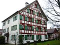
This is a category about a cultural property of regional significance in Switzerland with KGS number 11038
|
 | |||||
| Upload media | |||||
| Instance of | |||||
|---|---|---|---|---|---|
| Part of | |||||
| Location |
| ||||
| Street address |
| ||||
| Heritage designation |
| ||||
 | |||||
Media in category "Altes evangelisches Pfarrhaus (Sirnach)"
This category contains only the following file.
-
 Sirnach Unterdorf2.JPG 2,048 × 1,536; 1.52 MB