Category:Am Alten Berg 9 (Niederstetten)
Jump to navigation
Jump to search
| Object location | | View all coordinates using: OpenStreetMap |
|---|
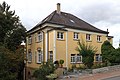
Deutsch: Wohnhaus und Garten, Am Alten Berg 9, 1927/31, Geschützt nach § 2 DSchG.
Media in category "Am Alten Berg 9 (Niederstetten)"
The following 2 files are in this category, out of 2 total.
-
 Am Alten Berg 9 01.jpg 5,115 × 3,410; 3.84 MB
-
 Am Alten Berg 9 02.jpg 5,184 × 3,456; 3.88 MB

