Category:Antonius van Paduakerk (Zwartemeer)
Jump to navigation
Jump to search
| Object location | | View all coordinates using: OpenStreetMap |
|---|
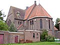
church building in Emmen, Netherlands  | |||||
| Upload media | |||||
| Instance of | |||||
|---|---|---|---|---|---|
| Part of | |||||
| Location | Zwartemeer, Emmen, Drenthe, Netherlands | ||||
| Street address |
| ||||
| Located on street |
| ||||
| Architect | |||||
| Heritage designation |
| ||||
| Religion or worldview | |||||
 | |||||
|
This is a category about rijksmonument number 510943
|
| Address |
|
Media in category "Antonius van Paduakerk (Zwartemeer)"
The following 7 files are in this category, out of 7 total.
-
 Interieur naar het koor - Zwartemeer - 20228044 - RCE.jpg 1,200 × 942; 242 KB
-
 Interieur naar het westen - Zwartemeer - 20228045 - RCE.jpg 954 × 1,200; 183 KB
-
 Noordgevel - Zwartemeer - 20228042 - RCE.jpg 1,200 × 936; 221 KB
-
 Oude Antoniuskerk Zwartemeer.jpg 1,000 × 750; 105 KB
-
 Overzicht - Zwartemeer - 20228040 - RCE.jpg 1,200 × 954; 171 KB
-
 Westgevel - Zwartemeer - 20228043 - RCE.jpg 960 × 1,200; 277 KB
-
 Zuidgevel - Zwartemeer - 20228041 - RCE.jpg 1,200 × 960; 255 KB


