Category:Apache Gap
Jump to navigation
Jump to search
English: The Apache Gap is a gap in the Superstition Mountains in Maricopa County, Arizona, 26 miles from Mesa, northeast of Willow Springs and the Willow Springs Well, at an elevation of 2,274 feet (693.12 m). The view here is from the Apache Trail (Arizona State Route 88). (Description sources: Home town locator and Mapcarta)
Media in category "Apache Gap"
The following 3 files are in this category, out of 3 total.
-
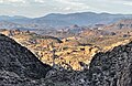 2021 Apache Gap from the Apache Trail 1.jpg 3,833 × 2,477; 1.62 MB
-
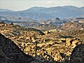 2021 Apache Gap from the Apache Trail 2.jpg 5,152 × 3,864; 4.65 MB
-
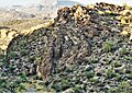 2021 Apache Gap, twisted rocks.jpg 3,118 × 2,197; 2.23 MB


