Category:Approaches and defenses of Knoxville, Tennessee, 1864
Jump to navigation
Jump to search
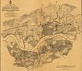
Map showing the defenses of Knoxville, Tennessee, USA, in late 1863 and 1864, based on a survey by Captain Orlando Poe.
Library of Congress title: "Topographical Map of the Approaches and Defences of Knoxville, E. Tennessee, shewing the positions occupied by the United States & Confederate Forces During the Siege. Surveyed by Direction of Capt. O.M. Poe, Chf. Engr., Dept. of the Ohio, during Dec., Jan. and Feb. 1863-4. Published by authority of the Hon. Secretary of War in the office of the Chief of Engineers, U.S. Army."
Media in category "Approaches and defenses of Knoxville, Tennessee, 1864"
The following 5 files are in this category, out of 5 total.
-
Civil-war-defenses-knoxville-1864-tn1.jpg 555 × 480; 77 KB
-
Kingston-road-civil-war-tn1.jpg 382 × 248; 37 KB
-
Knoxville-civil-war-defenses-south-1864-tn1.jpg 640 × 480; 141 KB
-
Knoxville-civil-war-defenses-west-1864-tn1.jpg 640 × 480; 124 KB
-
Map image2.jpg 640 × 480; 129 KB


