Category:Archbishop's Garden
Jump to navigation
Jump to search
| Object location | | View all coordinates using: OpenStreetMap |
|---|
park  | |||||
| Upload media | |||||
| Instance of | |||||
|---|---|---|---|---|---|
| Location | Eger, Eger District, Heves County, Hungary | ||||
 | |||||
Érsekkert teljes területe helyi védelem alatt áll. XIII. századtól vadaspark, 1730-as évektől díszkert, 1769-től fallal körülvett kert. - Heves megye, Eger, Helyrajzi szám: 6606/2, 6642/3,4,6,7.
|
This is a category about a monument in Hungary. Identifier: -359 |
Subcategories
This category has only the following subcategory.
P
Media in category "Archbishop's Garden"
The following 19 files are in this category, out of 19 total.
-
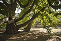 2013 Plane tree in Eger HU.jpg 5,000 × 3,333; 5.82 MB
-
 Bandstand in Archbishop's Garden.JPG 1,918 × 1,078; 1,001 KB
-
 Eger - Érsekkert -1a.jpg 4,450 × 3,024; 3.3 MB
-
 Eger - Érsekkert -1b.jpg 4,608 × 3,072; 3.21 MB
-
 Eger - Érsekkert -2.jpg 4,418 × 2,960; 2.9 MB
-
 Eger - Érsekkert -3.jpg 4,398 × 2,945; 3.28 MB
-
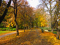
 Eger 2012, Érsekkert November colors - panoramio.jpg 4,608 × 3,456; 5.84 MB
-
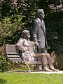 Eger – Érsekkert – Bródy–Gárdonyi Statue 01.jpg 600 × 800; 387 KB
-
 EgerErsekkertTancsicsSetany.jpg 636 × 476; 156 KB
-
 EgerErsekkertTo.jpg 635 × 477; 107 KB
-
 Fountain in Archbishop's Garden, Eger, 2016 Hungary.jpg 2,272 × 1,704; 1,023 KB
-
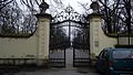
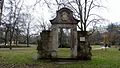 Jesuit Gate, Archbishop's Garden.JPG 1,920 × 1,080; 1.12 MB
-
 Klapka Street Gate, Archbishop's Garden.JPG 1,920 × 1,080; 999 KB
-
 Népkert déli bejárat - panoramio.jpg 6,016 × 4,000; 14.24 MB
-
 Stadion Street Gate, Archbishop's Garden.JPG 1,914 × 1,070; 1.26 MB
-
 Stone Betty by Jenő Kerényi in Archbishop's Garden, Eger, 2016 Hungary.jpg 2,272 × 1,704; 982 KB
-
 Stone bridge, Archbishop's Garden.JPG 1,920 × 1,080; 665 KB
-
 Érsekkert - panoramio.jpg 768 × 1,024; 390 KB
-
 Свадебный день-1 - panoramio.jpg 3,648 × 2,736; 3.55 MB


