Category:As River
Jump to navigation
Jump to search
Afrikaans: Die Asrivier, so genoem weens 'n wa-as wat naby die rivier gebreek het, is in die hooglande van die oos-Vrystaat geleë. Die water word by tye grootliks aangevul deur die Asrivieruitval naby Clarens, die noordelike eindpunt van die Lesotho-Hoogland-waterprojek se Leweringstonnel-noord.
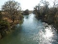
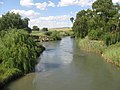
English: The As River (meaning axle river, so-called due to a wagon axle which broke near the river), is situated in the eastern Free State, South Africa. It is a conduit for water from the Lesotho Highlands Water Project via the As River Outfall, and along with the Liebenbergsvlei River, is impounded by the Saulspoort Dam near Bethlehem.
river in South Africa  | |||||
| Upload media | |||||
| Instance of | |||||
|---|---|---|---|---|---|
| Location | Free State, RSA | ||||
| Length |
| ||||
| Mouth of the watercourse | |||||
| Different from | |||||
 | |||||
Subcategories
This category has the following 2 subcategories, out of 2 total.
A
- As River Outfall (16 F)
S
- Saulspoort Dam (4 F)
Media in category "As River"
The following 9 files are in this category, out of 9 total.
-
 Asrivier naby Saulspoortdam, Bethlehem, Vrystaat, b.jpg 4,000 × 3,000; 4.33 MB
-
 Asrivier naby Saulspoortdam, Bethlehem, Vrystaat, stroomop.jpg 4,000 × 3,000; 4.25 MB
-
 Asrivier naby Saulspoortdam, Bethlehem, Vrystaat.jpg 4,000 × 3,000; 3.84 MB
-
 Asrivier, stroomaf by R712 suid van Bethlehem, Vrystaat.jpg 3,711 × 2,166; 3.21 MB
-
 Asrivier, stroomop by R712 suid van Bethlehem, Vrystaat.jpg 4,000 × 3,000; 4.06 MB
-
 Lesotho Water on its way to JHB - panoramio.jpg 1,600 × 1,200; 600 KB
-
 Lesotho Water on its way to the Rand - panoramio.jpg 1,600 × 1,200; 595 KB
-
 LHWP map resized.jpg 3,555 × 5,000; 10.06 MB
-
 Saulspoortdam, Asrivier-inloop, Bethlehem, Vrystaat.jpg 4,000 × 2,124; 3.44 MB


