Category:Aspatria
Jump to navigation
Jump to search

town and civil parish in Cumbria, United Kingdom  | |||||
| Upload media | |||||
| Instance of | |||||
|---|---|---|---|---|---|
| Location | Allerdale, Cumbria, North West England, England | ||||
| Said to be the same as | Aspatria (Wikimedia duplicated page, civil parish) | ||||
 | |||||
{{en|Aspatria is a town in Cumbria, England, and lies half way between Maryport and Wigton, on the A596. The church of St Kentigern's is the site of some pre-Norman stone crosses. The name "Aspatria" is Roman in origin and derives from the Latin Asp meaning a serpent and atrium meaning a clearing.
Polski: Aspatria - miasto w Wielkiej Brytanii, w Anglii, w regionie North West England, w hrabstwie Cumbria. W 2001r. miasto to zamieszkiwało 3 266 osób.
Română: Aspatria este un oraş în comitatul Cumbria, regiunea North West England, Anglia. Oraşul se află în districtul Allerdale.
Subcategories
This category has the following 7 subcategories, out of 7 total.
A
- Aspatria Boer War Memorial (1 F)
- Aspatria railway station (17 F)
B
- Brayton Hall (10 F)
K
P
- Pubs in Aspatria (4 F)
W
Media in category "Aspatria"
The following 200 files are in this category, out of 228 total.
(previous page) (next page)-
 002 Aspatria Viking finds.jpg 1,311 × 1,104; 509 KB
-
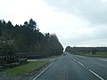
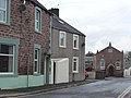
 A596 at Aspatria town boundary - geograph.org.uk - 4405094.jpg 640 × 480; 59 KB
-
 A596 at Cisswell Wood - geograph.org.uk - 4405089.jpg 640 × 480; 74 KB
-
 A596 King Street looking west - geograph.org.uk - 4405103.jpg 640 × 481; 102 KB
-
 A596 passes Brayton Park entrance - geograph.org.uk - 4405082.jpg 640 × 481; 42 KB
-
 Access road and footpath from Pasture House - geograph.org.uk - 4228213.jpg 1,024 × 768; 236 KB
-

-
 Animal fold created at the end of a farm track - geograph.org.uk - 4220484.jpg 1,024 × 768; 164 KB
-
 Arkelby Mill - geograph.org.uk - 48537.jpg 640 × 392; 103 KB
-
 Arkleby Road (B5301) - geograph.org.uk - 5124621.jpg 640 × 480; 77 KB
-
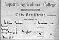 Aspatria Agricultural College Certificate circa 1893.jpg 2,237 × 1,506; 692 KB
-
 Aspatria Agricultural Cooperative Society Offices.jpg 1,577 × 995; 340 KB
-
 Aspatria fire station - geograph.org.uk - 1908290.jpg 640 × 427; 202 KB
-
 Aspatria Hornets Rugby League Football Club - geograph.org.uk - 4333807.jpg 1,024 × 768; 114 KB
-
 Aspatria Post Office - geograph.org.uk - 5125206.jpg 3,648 × 2,736; 1.41 MB
-
 Aspatria Rugby Union Football Club - geograph.org.uk - 4229979.jpg 1,024 × 768; 122 KB
-
 Aspatria Rugby Union Football Club - geograph.org.uk - 5124609.jpg 640 × 426; 60 KB
-
 Aspatria Station - geograph.org.uk - 5941203.jpg 1,024 × 671; 205 KB
-
 Aspatria's former drill hall, from the north - geograph.org.uk - 4332982.jpg 1,024 × 614; 84 KB
-
 Aspatria, west approach - geograph.org.uk - 51834.jpg 640 × 402; 83 KB
-
 Aspatrias former drill hall, from the west (geograph 4332977).jpg 1,024 × 768; 123 KB
-

-
 B5301 Outgang Road - geograph.org.uk - 4405108.jpg 640 × 481; 71 KB
-
 B5301 towards Aspatria - geograph.org.uk - 5125624.jpg 640 × 480; 65 KB
-
 B5301 towards Aspatria - geograph.org.uk - 5125635.jpg 640 × 480; 74 KB
-
 Bus stop on West Street, Aspatria - geograph.org.uk - 5124605.jpg 640 × 480; 65 KB
-
 Cafe - geograph.org.uk - 425164.jpg 640 × 480; 103 KB
-
 Castle Terrace, Aspatria - May 2017 - geograph.org.uk - 5411977.jpg 1,500 × 1,007; 1.27 MB
-
 Cattle pasture south of Lancarr Beck - geograph.org.uk - 4228144.jpg 1,024 × 768; 149 KB
-
 Cattle pasture west of Aspatria - geograph.org.uk - 4219526.jpg 1,024 × 768; 116 KB
-
 Cattle pasture, south of Hindrigg - geograph.org.uk - 4229257.jpg 1,024 × 768; 153 KB
-
 Chaos - geograph.org.uk - 425056.jpg 464 × 620; 147 KB
-
 Childs Play, King Street, Aspatria - geograph.org.uk - 4229969.jpg 1,024 × 768; 120 KB
-

-

-
 Detail of replica gosforth Cross 1.JPG 2,736 × 3,648; 4.71 MB
-
 Detail of Replica Gosforth Cross 2.JPG 2,736 × 3,648; 4.74 MB
-
 Disused pub, south side, King Street, Aspatria - geograph.org.uk - 4229960.jpg 1,024 × 768; 109 KB
-
 Dr William Perry Briggs Opening War Memorial 18 October 1922.jpg 2,244 × 1,350; 464 KB
-
 Edge of a stubble field, east of Whitelees - geograph.org.uk - 4220424.jpg 1,024 × 768; 156 KB
-
 Electricity infrastructure, west of the B5301 - geograph.org.uk - 4228191.jpg 1,024 × 768; 128 KB
-
-
 Elizabeth II postbox, Aspatria Post Office - geograph.org.uk - 5125204.jpg 2,690 × 2,542; 891 KB
-
 Farm building, Pasture House - geograph.org.uk - 4228226.jpg 983 × 738; 363 KB
-
 Farm track (footpath to Whitelees) - geograph.org.uk - 6330318.jpg 800 × 600; 110 KB
-
 Farmland and pylons near Aspatria - geograph.org.uk - 6330315.jpg 800 × 600; 82 KB
-
 Farmland between Pasture House and Hindrigg - geograph.org.uk - 4229205.jpg 1,024 × 768; 142 KB
-

-
 Farmland north-west of Castlemont, Aspatria - geograph.org.uk - 4220281.jpg 1,024 × 768; 152 KB
-
 Farmland on the south side of Lancarr Beck - geograph.org.uk - 4228131.jpg 1,024 × 768; 133 KB
-
 Farmland west of Aspatria - geograph.org.uk - 4219545.jpg 1,024 × 768; 155 KB
-
 Farmland west of Pasture House - geograph.org.uk - 4228218.jpg 1,024 × 768; 120 KB
-
 Farmland, Aspatria - geograph.org.uk - 4329486.jpg 640 × 427; 217 KB
-
 Farmland, Aspatria - geograph.org.uk - 4329516.jpg 640 × 480; 199 KB
-

-
 Fenced beck, south-east of Pasture House - geograph.org.uk - 4229193.jpg 1,024 × 768; 190 KB
-

-
 Field gate alongside a bend in the beck - geograph.org.uk - 4229187.jpg 1,024 × 768; 315 KB
-

-
 Fisher's Fryer, Queen Street, Aspatria - geograph.org.uk - 4229926.jpg 1,024 × 768; 118 KB
-

-
 Footbridge, Aspatria Railway Station - geograph.org.uk - 5124643.jpg 640 × 480; 94 KB
-

-

-
 Former "Fox ^ Hounds", Aspatria - May 2017 (1) - geograph.org.uk - 5411417.jpg 1,500 × 1,118; 1.34 MB
-
 Former "Fox ^ Hounds", Aspatria - May 2017 (2) - geograph.org.uk - 5411420.jpg 1,500 × 1,113; 1.34 MB
-

-
 Former "NatWest" Bank - Aspatria - May 2017 - geograph.org.uk - 5411973.jpg 1,353 × 1,500; 1.72 MB
-

-
 Former "Station Hotel", Aspatria - May 2017 - geograph.org.uk - 5411962.jpg 1,500 × 989; 1.14 MB
-
 Former chapel, Outgang Road, Aspatria - geograph.org.uk - 4229976.jpg 1,023 × 768; 104 KB
-
 Former Market Hall, Aspatria - May 2017 - geograph.org.uk - 5391667.jpg 1,250 × 985; 1,016 KB
-

-
 Grave Stone Memorial.JPG 2,736 × 3,648; 4.71 MB
-
 Grazing and pylons west of Aspatria - geograph.org.uk - 6330319.jpg 800 × 600; 70 KB
-

-
 Grazing near sewage works - geograph.org.uk - 5267838.jpg 640 × 427; 84 KB
-
 Grazing near Wellington Farm - geograph.org.uk - 5123711.jpg 640 × 445; 58 KB
-
 Grazing near Whitelees - geograph.org.uk - 6330324.jpg 800 × 600; 57 KB
-
 Grazing near Yearngill - geograph.org.uk - 5125612.jpg 640 × 480; 60 KB
-
 Grazing west of the B5301, Aspatria - geograph.org.uk - 5124616.jpg 640 × 480; 76 KB
-
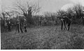
 Gun Club circa 1905.jpg 2,286 × 1,662; 783 KB
-
 Harriston Road, Aspatria - geograph.org.uk - 4229294.jpg 1,024 × 768; 112 KB
-
 Harriston Road, Aspatria - geograph.org.uk - 5124526.jpg 640 × 480; 56 KB
-
 Heading south east on the B5301 - geograph.org.uk - 5125637.jpg 640 × 480; 66 KB
-
 Hindrigg, north of Aspatria - geograph.org.uk - 4229252.jpg 1,024 × 768; 119 KB
-
 Holiday cottages at Pasture House - geograph.org.uk - 4228232.jpg 1,024 × 768; 132 KB
-
 House on Arkleby Road (B5301) - geograph.org.uk - 5124623.jpg 640 × 480; 53 KB
-
 House on the A596, Aspatria - geograph.org.uk - 5124544.jpg 640 × 480; 53 KB
-
 Houses on North Road, Aspatria - geograph.org.uk - 5125639.jpg 640 × 480; 51 KB
-
 Houses on Queen Street, Aspatria - geograph.org.uk - 5124534.jpg 640 × 480; 58 KB
-
 Houses on West Street, Aspatria - geograph.org.uk - 5124601.jpg 640 × 480; 82 KB
-
 Houses, north side, Queen Street, Aspatria - geograph.org.uk - 4229277.jpg 1,024 × 768; 122 KB
-
 Houses, south side, Queen Street, Aspatria - geograph.org.uk - 4229302.jpg 768 × 1,024; 109 KB
-
 Johanna Terrace, Aspatria - geograph.org.uk - 5124612.jpg 640 × 444; 60 KB
-
 King Street (A596), Aspatria - geograph.org.uk - 5124556.jpg 640 × 480; 61 KB
-
 Mary Lawson circa 1900.jpg 695 × 1,139; 178 KB
-
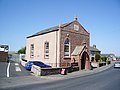
 Methodist Church, Aspatria - geograph.org.uk - 425045.jpg 640 × 480; 103 KB
-
 Methodist Church, Aspatria - May 2017 - geograph.org.uk - 5391556.jpg 1,250 × 747; 1.08 MB
-
 Minor road from Aspatria to Hayton - geograph.org.uk - 6330314.jpg 800 × 600; 80 KB
-
 Minor road from Aspatria to Hayton - geograph.org.uk - 6330320.jpg 800 × 600; 81 KB
-

-
 Muddy entrance to Hindrigg farmyard - geograph.org.uk - 4229235.jpg 1,024 × 768; 151 KB
-
 Muddy field entrance near Aspatria - geograph.org.uk - 6330312.jpg 800 × 600; 100 KB
-
 Noble Temple - geograph.org.uk - 425018.jpg 640 × 480; 104 KB
-
 Noble Temple, Aspatria - May 2017 - geograph.org.uk - 5391583.jpg 1,250 × 1,101; 1.33 MB
-

-
 Pasture, Aspatria - geograph.org.uk - 4329475.jpg 640 × 480; 174 KB
-
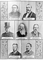 Personalities Associated with the Aspatria Agricultural College circa 1893.jpg 1,596 × 2,208; 914 KB
-
 Political Song relating to the 1827 Carlisle Election.jpg 664 × 800; 162 KB
-

-
 Power lines east of Pasture House - geograph.org.uk - 4229198.jpg 1,024 × 614; 123 KB
-

-
 Public footpath heading east from Whitelees - geograph.org.uk - 4220444.jpg 1,024 × 768; 226 KB
-

-
 Public footpath heading west to Whitelees - geograph.org.uk - 4220311.jpg 1,024 × 768; 167 KB
-
 Public footpath heading west to Whitelees - geograph.org.uk - 4220413.jpg 1,024 × 768; 212 KB
-
 Public footpath running east from Whitelees - geograph.org.uk - 4228141.jpg 1,024 × 768; 173 KB
-
 Public footpath stile, Hindrigg - geograph.org.uk - 4229239.jpg 1,024 × 768; 171 KB
-
 Public footpath to Hindrigg - geograph.org.uk - 4229175.jpg 1,024 × 768; 175 KB
-
 Public footpath to Hindrigg and Lawson Street - geograph.org.uk - 4229223.jpg 1,024 × 768; 193 KB
-
 Public footpath to Lancarr Beck - geograph.org.uk - 4228177.jpg 1,024 × 768; 152 KB
-
 Public footpath to Whitelees - geograph.org.uk - 6330322.jpg 800 × 600; 119 KB
-
 Pylons on the north side of a public footpath - geograph.org.uk - 4228180.jpg 1,024 × 768; 127 KB
-
 Pylons, near Aspatria - geograph.org.uk - 51832.jpg 640 × 480; 80 KB
-
 Railway towards Carlisle - geograph.org.uk - 5124538.jpg 640 × 480; 92 KB
-
 Railway towards Carlisle - geograph.org.uk - 5124650.jpg 640 × 480; 89 KB
-
 Railway towards Maryport - geograph.org.uk - 5124627.jpg 640 × 480; 71 KB
-

-
 Right (south) for Aspatria - geograph.org.uk - 4228160.jpg 1,024 × 768; 211 KB
-
 River Ellen - geograph.org.uk - 112664.jpg 640 × 480; 69 KB
-
 River Ellen near Harriston - geograph.org.uk - 269430.jpg 640 × 512; 103 KB
-
 Rolling farmland, east of Whitelees - geograph.org.uk - 4220374.jpg 1,024 × 768; 151 KB
-
 Sewage treatment plant near Aspatria - geograph.org.uk - 5267836.jpg 640 × 389; 47 KB
-
 Sheep pasture north of Hindrigg - geograph.org.uk - 4229227.jpg 1,024 × 768; 130 KB
-
 Sheila Fell Memorial - Aspatria - May 2017 - geograph.org.uk - 5391562.jpg 1,250 × 789; 1.08 MB
-
 Sheila Fell Memorial, Aspatria.JPG 3,648 × 2,736; 4.84 MB
-
 Shops on Queen Street, Aspatria - geograph.org.uk - 5124524.jpg 640 × 480; 61 KB
-
 Sign for the Red Lion, Aspatria - geograph.org.uk - 5124598.jpg 991 × 1,380; 211 KB
-
 Sign on the Sun Inn, Aspatria - geograph.org.uk - 5124565.jpg 353 × 640; 48 KB
-
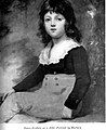 Sir James Graham as a child.jpg 654 × 800; 103 KB
-
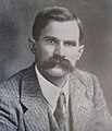
 Sir John Randles.jpg 1,559 × 930; 859 KB
-

-
 Sir Wilfred Lawson's memorial fountain, Aspatria - geograph.org.uk - 4333791.jpg 1,024 × 768; 139 KB
-
 Sir Wilfrid Lawson and Robert Watson UKA.jpg 954 × 1,578; 687 KB
-

-

-
 Springkell, Aspatria - geograph.org.uk - 4229246.jpg 1,024 × 768; 175 KB
-
 Station sign, Aspatria Railway Station - geograph.org.uk - 5124651.jpg 463 × 640; 137 KB
-
 Stubble field and hedgerow - geograph.org.uk - 5125627.jpg 3,648 × 2,736; 1.8 MB
-
 Stubble field north of Aspatria - geograph.org.uk - 5125629.jpg 640 × 480; 62 KB
-
 Surveying and mensuration class, Aspatria Agricultural College circa 1905.jpg 2,214 × 1,361; 605 KB
-
 Technique Hair Studio, Aspatria - geograph.org.uk - 4229287.jpg 1,024 × 768; 121 KB
-
 Terraced houses, east side, Springkell, Aspatria - geograph.org.uk - 4229263.jpg 1,024 × 768; 124 KB
-

-
 The Aspatria Agricultural College (circa 1874).jpg 2,471 × 1,901; 724 KB
-
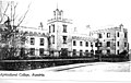 The Aspatria Agricultural College.jpg 2,291 × 1,446; 575 KB
-
 The B5301 passing the entrance to Pasture Farm - geograph.org.uk - 4228198.jpg 1,024 × 768; 105 KB
-
 The Brayton Blazers.jpg 1,968 × 1,338; 531 KB
-
 The Dinning Hall.jpg 2,208 × 1,308; 354 KB
-
 The end of the farm track, east of Whitelees - geograph.org.uk - 4220331.jpg 1,024 × 768; 161 KB
-
 The footpath to Station Road, Aspatria - geograph.org.uk - 4219490.jpg 1,024 × 768; 172 KB
-
 The footpath to West Street, Aspatria - geograph.org.uk - 4219494.jpg 1,024 × 768; 171 KB
-
 The Grapes Hotel, Aspatria - May 2017 (1) - geograph.org.uk - 5391717.jpg 1,250 × 593; 639 KB
-
 The Grapes Hotel, Aspatria - May 2017 (2) - geograph.org.uk - 5391720.jpg 1,250 × 1,090; 1.11 MB
-
 The Grapes Hotel, Aspatria - May 2017 (3) - geograph.org.uk - 5391734.jpg 1,250 × 854; 1.13 MB
-
 The Grapes Hotel, Aspatria - May 2017 (4) - geograph.org.uk - 5411964.jpg 1,500 × 1,405; 1.74 MB
-
 The Lake District Creamery, Aspatria - geograph.org.uk - 6422663.jpg 1,024 × 768; 130 KB
-
 The Lecture Theatre.jpg 2,208 × 1,308; 429 KB
-
 The Letters Inn, Aspatria - May 2017 (1) - geograph.org.uk - 5411941.jpg 1,500 × 1,144; 1.47 MB
-
 The Letters Inn, Aspatria - May 2017 (2) - geograph.org.uk - 5411945.jpg 1,500 × 874; 1.18 MB
-
 The Natural History Museum.jpg 2,142 × 1,308; 423 KB
-
 The Old Manse, Aspatria - May 2017 - geograph.org.uk - 5391581.jpg 1,243 × 1,250; 1.43 MB
-
 The Red Lion - Aspatria - May 2017 - geograph.org.uk - 5391772.jpg 1,250 × 775; 1.05 MB
-
 The Red Lion, Aspatria - geograph.org.uk - 5124597.jpg 640 × 428; 67 KB
-
 The Red Lion, West Street, Aspatria - geograph.org.uk - 4219505.jpg 1,024 × 768; 128 KB
-
 The Replica Gosforth Cross, Aspatria.JPG 2,736 × 3,648; 4.65 MB
-
 The road to Hayton - geograph.org.uk - 4219510.jpg 1,024 × 768; 128 KB
-
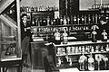 The Science Laboratory.jpg 1,968 × 1,320; 428 KB
-
 The Sun Inn, Aspatria - geograph.org.uk - 5124562.jpg 640 × 480; 57 KB
-
 The Sun Inn, Aspatria - May 2017 (1) - geograph.org.uk - 5391648.jpg 1,250 × 852; 809 KB
-
 The Sun Inn, Aspatria - May 2017 (2) - geograph.org.uk - 5391651.jpg 1,250 × 1,008; 936 KB
-
 The Sun Inn, Aspatria - May 2017 (3) - geograph.org.uk - 5391659.jpg 1,250 × 730; 715 KB
-
 The Vaults, King Street, Aspatria - geograph.org.uk - 4229940.jpg 1,024 × 768; 133 KB
-
 Track and footpath running north from Aspatria - geograph.org.uk - 4228163.jpg 1,024 × 768; 164 KB
-
 Track with issues, west of Aspatria - geograph.org.uk - 4220298.jpg 1,024 × 768; 183 KB
-
 Undulating farmland, north of Aspatria - geograph.org.uk - 4228170.jpg 1,024 × 768; 176 KB
-
 Undulating stubble field, east of Whitelees - geograph.org.uk - 4220425.jpg 1,024 × 768; 156 KB
-
 Waterlogged field corner, Pasture House - geograph.org.uk - 4228228.jpg 1,024 × 768; 161 KB
-
 Waterlogged field, south of Pasture House - geograph.org.uk - 4229172.jpg 1,024 × 768; 142 KB
-
 Waterlogged footpath near a 61 metre spot height - geograph.org.uk - 4228187.jpg 1,024 × 768; 128 KB
-

-
 West Street (A596), Aspatria - geograph.org.uk - 5124603.jpg 640 × 451; 58 KB
-
 William Perry Briggs M.D..jpg 1,211 × 1,866; 494 KB
-
 William Wilson Academic.jpg 904 × 1,049; 498 KB
-

-
 Windswept tree on southern field boundary - geograph.org.uk - 4228129.jpg 1,024 × 768; 138 KB
-
 Yellow and green field at Pasture House - geograph.org.uk - 4229169.jpg 1,024 × 768; 159 KB
-
 Arable land, west of Aspatria - geograph.org.uk - 52000.jpg 640 × 480; 131 KB
-
 Arkleby Mill - geograph.org.uk - 269258.jpg 640 × 512; 60 KB


_-_geograph.org.uk_-_5124621.jpg)


.jpg)


_-_geograph.org.uk_-_6330318.jpg)


_-_geograph.org.uk_-_5411417.jpg)
_-_geograph.org.uk_-_5411420.jpg)


_-_geograph.org.uk_-_5124623.jpg)


,_Aspatria_-_geograph.org.uk_-_5124556.jpg)


_for_Aspatria_-_geograph.org.uk_-_4228160.jpg)


.jpg)


_-_geograph.org.uk_-_5391717.jpg)
_-_geograph.org.uk_-_5391720.jpg)
_-_geograph.org.uk_-_5391734.jpg)
_-_geograph.org.uk_-_5411964.jpg)


_-_geograph.org.uk_-_5411941.jpg)
_-_geograph.org.uk_-_5411945.jpg)


_-_geograph.org.uk_-_5391648.jpg)
_-_geograph.org.uk_-_5391651.jpg)
_-_geograph.org.uk_-_5391659.jpg)


,_Aspatria_-_geograph.org.uk_-_5124603.jpg)


