Category:Assendelftstraat 14, The Hague
Jump to navigation
Jump to search
| Object location | | View all coordinates using: OpenStreetMap |
|---|
building in The Hague, Netherlands  | |||||
| Upload media | |||||
| Instance of | |||||
|---|---|---|---|---|---|
| Location | The Hague, South Holland, Netherlands | ||||
| Street address |
| ||||
| Located on street | |||||
| Heritage designation |
| ||||
 | |||||
|
This is a category about rijksmonument number 17455
|
| Address |
|
Media in category "Assendelftstraat 14, The Hague"
The following 3 files are in this category, out of 3 total.
-
 DenHaag Assendelftstraat14.jpg 2,736 × 3,648; 4.94 MB
-
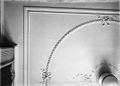 Interieur, plafond - 's-Gravenhage - 20410504 - RCE.jpg 1,200 × 855; 133 KB
-
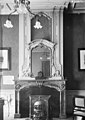 Schoorsteen - 's-Gravenhage - 20088101 - RCE.jpg 852 × 1,200; 181 KB

