Category:Aston Clinton
Jump to navigation
Jump to search
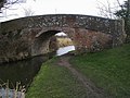
English: Aston Clinton is a village and civil parish that sits close to the main A41 road in Buckinghamshire, England between Tring and Aylesbury. The parish is 3,809 acres (15 km²) in size and is about 4 miles (6 km) east of Aylesbury. The parish had a population of 3,542 according to the 2001 census. The village is located at the foot of the chalk escarpment of the Chiltern Hills at the junction of the pre-historic track the Icknield Way with the Roman Road Akeman Street. It is bisected both at the northern end of the parish by the Aylesbury Arm and in the centre of the parish by the Wendover Arm of the Grand Union Canal.
Svenska: Aston Clinton är en stad och civil parish i Buckinghamshire i England. Staden ligger mellan Tring och Aylesbury, vid foten av kalkstensbergen Chiltern Hills.
village in Buckinghamshire, England, UK  | |||||
| Upload media | |||||
| Instance of | |||||
|---|---|---|---|---|---|
| Location | Buckinghamshire, South East England, England | ||||
 | |||||
Subcategories
This category has the following 3 subcategories, out of 3 total.
A
- Aston Clinton Ragpits (7 F)
Media in category "Aston Clinton"
The following 200 files are in this category, out of 230 total.
(previous page) (next page)-
 A clear bit of canal - geograph.org.uk - 4688477.jpg 4,000 × 2,664; 3.96 MB
-
 A Fallen Giant in Cobblers Pits - geograph.org.uk - 1311636.jpg 640 × 480; 300 KB
-

-

-
 A Mowed Strip across a Giant Lawn - geograph.org.uk - 1310475.jpg 640 × 480; 218 KB
-
 A narrowboat enters Red House Lock, Aylesbury Arm - geograph.org.uk - 4166454.jpg 3,648 × 2,736; 4.42 MB
-
 A narrowboat leaves the empty Red House Lock, Aylesbury Arm - geograph.org.uk - 4166461.jpg 3,648 × 2,736; 4.46 MB
-

-
 A taste of the Orient - geograph.org.uk - 26653.jpg 640 × 480; 20 KB
-
 A41 at The Vatches - geograph.org.uk - 3010312.jpg 640 × 480; 66 KB
-

-
 A41 near Dropshort Farm - geograph.org.uk - 3010309.jpg 640 × 480; 61 KB
-

-
 A41 west of College Road bridge - geograph.org.uk - 3010311.jpg 640 × 480; 65 KB
-
 Acar2go on London Road, Aston Clinton - geograph.org.uk - 5639876.jpg 2,304 × 1,728; 873 KB
-
 Alderfly (Sialis lutaria) (34402497043).jpg 1,177 × 881; 544 KB
-
 An arable field on Aston Hill - geograph.org.uk - 1882737.jpg 1,500 × 1,000; 267 KB
-
 Arable field on Aston Hill - geograph.org.uk - 1882743.jpg 1,500 × 1,000; 292 KB
-
 Arla grows - view from College Road - geograph.org.uk - 3288454.jpg 1,333 × 1,000; 813 KB
-
 Arla panorama (under construction) - geograph.org.uk - 3288451.jpg 3,937 × 1,000; 2.87 MB
-
 Arla under construction - geograph.org.uk - 3288453.jpg 1,333 × 1,000; 1.06 MB
-
 Aston Clinton - Grand Union Canal Aylesbury Arm Bridge Number 10 - 20231125111004.jpg 4,000 × 3,000; 5.31 MB
-
 Aston Clinton - Grand Union Canal Aylesbury Arm Bridge Number 10 - 20231125111058.jpg 4,000 × 3,000; 2.39 MB
-
 Aston Clinton - Grand Union Canal Aylesbury Arm Bridge Number 10 - 20231125111102.jpg 4,000 × 3,000; 4.35 MB
-
 Aston Clinton - The Old School - geograph.org.uk - 148461.jpg 640 × 480; 92 KB
-

-
 Aston Clinton cricket ground - geograph.org.uk - 2680104.jpg 640 × 480; 72 KB
-
 Aston Clinton cricket ground, Buckinghamshire, England.jpg 640 × 480; 89 KB
-
 Aston Clinton Field Bridge No 10 - geograph.org.uk - 4960318.jpg 800 × 438; 136 KB
-
 Aston Clinton Football Club - geograph.org.uk - 571668.jpg 640 × 480; 89 KB
-
 Aston Clinton from the church tower - geograph.org.uk - 199351.jpg 640 × 480; 113 KB
-
 Aston Clinton sunrise.JPG 3,872 × 2,592; 2.35 MB
-
 Aston Clinton Veterinery Centre - geograph.org.uk - 989700.jpg 640 × 413; 61 KB
-
 Aston Clinton, Aylesbury Road - geograph.org.uk - 148452.jpg 640 × 480; 82 KB
-
 Aston Clinton, The Baptist Church - geograph.org.uk - 148672.jpg 640 × 480; 118 KB
-
 Aston Clinton, The Oak - geograph.org.uk - 148845.jpg 640 × 480; 90 KB
-
 Aston Hill - geograph.org.uk - 4483494.jpg 2,560 × 1,920; 2.48 MB
-
 Aston Hill - geograph.org.uk - 4483496.jpg 2,560 × 1,920; 1.92 MB
-
 Aston Hill - geograph.org.uk - 4484542.jpg 2,560 × 1,920; 1.94 MB
-
 Aston Hill Lodge, Aston Hill, Halton - geograph.org.uk - 1263091.jpg 640 × 480; 119 KB
-
 Aylesbury arm - geograph.org.uk - 5212981.jpg 5,184 × 3,456; 7.01 MB
-
 Aylesbury arm bridge 10 - geograph.org.uk - 5212978.jpg 5,170 × 2,736; 4.84 MB
-
 Aylesbury Arm Canal near Merrymead Farm - geograph.org.uk - 4890891.jpg 800 × 615; 141 KB
-
 Aylesbury arm from bridge no 9 - geograph.org.uk - 5212952.jpg 4,716 × 3,087; 3.29 MB
-
 Aylesbury Arm of the Grand Union Canal - geograph.org.uk - 4960366.jpg 800 × 634; 188 KB
-
 Aylesbury arm towpath - geograph.org.uk - 5212976.jpg 4,505 × 3,027; 3.46 MB
-
 Aylesbury Road - geograph.org.uk - 2680110.jpg 640 × 480; 69 KB
-
 Aylesbury Road, Aston Clinton - geograph.org.uk - 5640604.jpg 2,304 × 1,728; 1.05 MB
-
 Aylesbury Road, Aston Clinton - geograph.org.uk - 5640608.jpg 2,304 × 1,728; 1.01 MB
-
 Aylesbury Road, Aston Clinton - geograph.org.uk - 5643352.jpg 2,304 × 1,728; 880 KB
-
 Aylesbury seen from Aston Hill - geograph.org.uk - 4299563.jpg 4,320 × 3,240; 4.66 MB
-
 Barn by the Ridgeway at Chivery - geograph.org.uk - 1320670.jpg 640 × 480; 107 KB
-

-
 Bridge 10 - geograph.org.uk - 2679958.jpg 640 × 480; 85 KB
-
 Bridge 10 Aylesbury Arm Grand Union Canal - geograph.org.uk - 4166417.jpg 3,648 × 2,736; 4.53 MB
-
 Bridge 9 and Red House Lock - geograph.org.uk - 2679963.jpg 640 × 480; 107 KB
-
 Bridge 9, College Road - geograph.org.uk - 5212951.jpg 5,202 × 3,465; 3.91 MB
-
-
 Bridleway to Puttenham - geograph.org.uk - 2679969.jpg 640 × 480; 112 KB
-
 Canal reflections at Red House Lock - geograph.org.uk - 6006546.jpg 4,608 × 3,456; 4.38 MB
-
 Canalside Bungalow at Merrymead Farm - geograph.org.uk - 1227507.jpg 630 × 480; 170 KB
-
 Cattle near Chivery - geograph.org.uk - 2403519.jpg 2,352 × 1,767; 1.91 MB
-
 China Water Restaurant - geograph.org.uk - 5389975.jpg 1,600 × 1,200; 354 KB
-
 Chivery Cottage from Black Wood - geograph.org.uk - 3183910.jpg 1,333 × 1,000; 1.1 MB
-
 Chivery Reservoir - geograph.org.uk - 139505.jpg 640 × 487; 123 KB
-
 Chivery village - geograph.org.uk - 4484564.jpg 2,560 × 1,920; 2.11 MB
-
 Chivery village - geograph.org.uk - 4484616.jpg 2,560 × 1,920; 1.41 MB
-

-

-
 College Road Bridge No 9 - geograph.org.uk - 4890844.jpg 800 × 527; 154 KB
-
 College Road bridge, A41 - geograph.org.uk - 3010310.jpg 640 × 480; 60 KB
-
 College Road Winding Hole - geograph.org.uk - 4960306.jpg 800 × 591; 116 KB
-

-

-
 Cow (33641101684).jpg 3,809 × 2,863; 3.46 MB
-
 Cow (34098276720).jpg 4,005 × 3,015; 3.95 MB
-
 Cow and calf (34124582650).jpg 3,963 × 2,974; 3.35 MB
-
 Cow and calf (34124586000).jpg 4,288 × 3,216; 4.53 MB
-
 Cyclists on the Upper Icknield way - geograph.org.uk - 4299530.jpg 2,885 × 2,162; 1.96 MB
-
 Driveway, to High Meadow Farm - geograph.org.uk - 1440522.jpg 640 × 480; 118 KB
-
 End of Entrance Track, Dancersend Nature Reserve - geograph.org.uk - 4095366.jpg 4,000 × 2,667; 2.32 MB
-

-
 Entrance to Aston Hill Farm - geograph.org.uk - 1542661.jpg 640 × 480; 88 KB
-

-
 Field Hedge Line - geograph.org.uk - 6029172.jpg 640 × 480; 73 KB
-
 Field near Chivery - geograph.org.uk - 576934.jpg 640 × 480; 85 KB
-
 Field north of Wendover Woods - geograph.org.uk - 2343515.jpg 1,500 × 1,125; 1.92 MB
-
 Fields near Chivery - geograph.org.uk - 4802206.jpg 3,264 × 1,840; 2.02 MB
-
 Fly Tipping near Aston Clinton - geograph.org.uk - 2903918.jpg 2,592 × 1,944; 2.54 MB
-
 Footpath in Wendover Woods - geograph.org.uk - 1884787.jpg 1,500 × 967; 336 KB
-
 Footpath on Aston Hill - geograph.org.uk - 6292044.jpg 4,000 × 3,000; 2.97 MB
-
 Footpath on Aston Hill - geograph.org.uk - 6292047.jpg 4,000 × 3,000; 2.83 MB
-

-
 Footpath past High Meadow Farm - geograph.org.uk - 1201979.jpg 480 × 640; 176 KB
-
 Garden furniture near Red House lock - geograph.org.uk - 5212945.jpg 4,856 × 3,173; 3.96 MB
-
 GOC Tring & Wendover Woods 080 Wendover Arm, Aston Clinton (34841784065).jpg 4,608 × 3,456; 5.01 MB
-

-

-

-
 Grand Union Canal - geograph.org.uk - 2166952.jpg 640 × 480; 127 KB
-
 Grand Union Canal, Aylesbury Arm - geograph.org.uk - 135964.jpg 640 × 480; 119 KB
-

-

-

-

-

-
 Green Park, from A4011 - geograph.org.uk - 135458.jpg 640 × 480; 54 KB
-
 Harelane Bridge - geograph.org.uk - 3547003.jpg 2,048 × 1,536; 526 KB
-
 High Meadow Farm (Beware of the Dogs ^) - geograph.org.uk - 139550.jpg 640 × 480; 121 KB
-
 High Meadow Farm - through the hedge - geograph.org.uk - 139555.jpg 640 × 480; 135 KB
-
 High Meadow Farm, Aston Hill, Chivery - geograph.org.uk - 1201919.jpg 640 × 480; 108 KB
-
 House on Aylesbury Road, Aston Clinton - geograph.org.uk - 5643353.jpg 2,188 × 1,566; 833 KB
-
 House with a view - geograph.org.uk - 139542.jpg 640 × 480; 98 KB
-
 Industrial buildings on College Road Industrial Estate - geograph.org.uk - 2903924.jpg 2,416 × 1,811; 714 KB
-
 Ivy-covered trees by the Road - geograph.org.uk - 1201940.jpg 640 × 480; 161 KB
-
 Klargester Factory, College Road North - geograph.org.uk - 1270027.jpg 640 × 384; 117 KB
-
 Lane heading to St Leonards - geograph.org.uk - 1566195.jpg 640 × 480; 84 KB
-

-
 London Road, Aston Clinton - geograph.org.uk - 5640619.jpg 2,010 × 1,484; 1.13 MB
-
 London Road, Buckland - geograph.org.uk - 5640634.jpg 2,048 × 1,536; 971 KB
-
 Long Meadow Farm - geograph.org.uk - 1542706.jpg 640 × 480; 69 KB
-
 Longcroft, Aston Clinton - geograph.org.uk - 4715644.jpg 3,960 × 2,272; 1.96 MB
-
 Looking along the slope - geograph.org.uk - 1884771.jpg 1,500 × 1,000; 254 KB
-
 Looking north west from Aston Hill - geograph.org.uk - 4299547.jpg 4,320 × 3,240; 4.15 MB
-
 Looking northwest towards Aylesbury - geograph.org.uk - 135451.jpg 640 × 480; 59 KB
-
 Looking over the Meadow Plots at Dancersend Reserve - geograph.org.uk - 4095430.jpg 4,000 × 3,000; 3.3 MB
-
 Looking over Wendover Woods - geograph.org.uk - 1884767.jpg 1,500 × 1,000; 333 KB
-
 Looking South along College Road N - geograph.org.uk - 1270037.jpg 640 × 384; 97 KB
-

-
 Memorial flight fly-past, Aston Clinton - geograph.org.uk - 4077289.jpg 1,598 × 1,000; 846 KB
-

-
 Mountain Bike Area Sign, Aston Hill - geograph.org.uk - 1542665.jpg 640 × 480; 86 KB
-
 Narrow boat reflection, Aylesbury Arm - geograph.org.uk - 3288443.jpg 1,000 × 1,333; 1.14 MB
-

-
 Narrowboats at permanent mooring, Aylesbury Arm - geograph.org.uk - 4166434.jpg 3,648 × 2,736; 2.53 MB
-
 Near Lodge Farm - geograph.org.uk - 256963.jpg 640 × 480; 75 KB
-
 New development with Pharmacy - geograph.org.uk - 26652.jpg 640 × 479; 47 KB
-
 Old cast metal sign for Bridge 9, Aylesbury Arm canal - geograph.org.uk - 4166476.jpg 3,648 × 2,736; 3.93 MB
-

-
 Old school building on London Road - geograph.org.uk - 5392206.jpg 1,600 × 1,200; 545 KB
-
 Outer Aylesbury Ring - geograph.org.uk - 4781670.jpg 640 × 480; 134 KB
-
 Outer Aylesbury Ring - geograph.org.uk - 4781706.jpg 640 × 480; 128 KB
-
 Outer Aylesbury Ring - geograph.org.uk - 4781714.jpg 640 × 480; 118 KB
-
 Park Farm - geograph.org.uk - 5392189.jpg 1,600 × 1,200; 563 KB
-

-
 Path coming down to Tatnall's Wood - geograph.org.uk - 6029105.jpg 640 × 480; 127 KB
-
 Path in Bittam's Wood - geograph.org.uk - 6029109.jpg 640 × 480; 129 KB
-
 Path in Black Wood - geograph.org.uk - 3183894.jpg 1,333 × 1,000; 1.41 MB
-
 Piled Skips on industrial site near Aston Clinton - geograph.org.uk - 2903929.jpg 2,592 × 1,944; 1.86 MB
-
 RAF Halton from the air - geograph.org.uk - 2356016.jpg 462 × 640; 177 KB
-
 Rear of Aston Court, Aston Hill - geograph.org.uk - 1542656.jpg 640 × 480; 80 KB
-
 Red house - at Red House Lock, Aylesbury Arm canal - geograph.org.uk - 4166443.jpg 3,328 × 2,496; 2.33 MB
-
 Red House Lock - geograph.org.uk - 6006552.jpg 4,608 × 3,456; 5.51 MB
-
 Red House Lock No 13 - geograph.org.uk - 4890826.jpg 800 × 544; 146 KB
-
 Red House Lock No 13 - geograph.org.uk - 4890853.jpg 800 × 600; 187 KB
-
 Red House lock, bottom gate - geograph.org.uk - 3288441.jpg 1,415 × 1,000; 1.33 MB
-
 Red House lock, top gate - geograph.org.uk - 3299857.jpg 1,333 × 1,000; 1.29 MB
-
 Red House next to College Road North - geograph.org.uk - 4890865.jpg 800 × 600; 165 KB
-
 Reduce Speed Now - geograph.org.uk - 3010315.jpg 640 × 480; 67 KB
-
 Ridgeway long distance path - geograph.org.uk - 2403512.jpg 2,232 × 1,670; 2.11 MB
-
 Rosebery Road, Aston Clinton - geograph.org.uk - 4715649.jpg 3,756 × 2,156; 1.48 MB
-
 Rotting Wood Pile for Wildlife at Dancersend Reserve - geograph.org.uk - 4095498.jpg 4,000 × 3,000; 2.61 MB
-

-
 Service station in Aston Clinton - geograph.org.uk - 988954.jpg 640 × 384; 53 KB
-
 Sheep on High Meadow Farm - geograph.org.uk - 1201924.jpg 640 × 480; 115 KB
-

-

-
 St Leonards, Chivery - geograph.org.uk - 4484650.jpg 2,560 × 1,920; 2.08 MB
-
 Start of footpath past High Meadow Farm - geograph.org.uk - 1201976.jpg 640 × 480; 191 KB
-
 Telephone Exchange, Aston Clinton - geograph.org.uk - 894052.jpg 640 × 480; 91 KB
-
 Terrace of houses on Aylesbury Road, Aston Clinton - geograph.org.uk - 5640597.jpg 2,168 × 1,626; 853 KB
-
 The A41, Aston Clinton - geograph.org.uk - 6179565.jpg 1,906 × 1,260; 1.38 MB
-

-

-
 The B4009 on Aston Hill - geograph.org.uk - 1882745.jpg 1,500 × 974; 175 KB
-
 The Bell, Aston Clinton - geograph.org.uk - 2598914.jpg 1,000 × 610; 194 KB
-
 The Bottle Making Plant in the Arla Factory at Aston Clinton - geograph.org.uk - 5832059.jpg 3,500 × 2,624; 1.81 MB
-
 The Cross Paths Junction in Dancers End Reserve - geograph.org.uk - 4095535.jpg 4,000 × 2,666; 2.85 MB
-
 The final corner on the tarmac road through Wendover Woods - geograph.org.uk - 5974323.jpg 3,648 × 2,736; 2.67 MB
-

-
 The harvest is in but the straw awaits collection - geograph.org.uk - 6292049.jpg 4,000 × 3,000; 3.17 MB
-
-

-
 The Meadow Plots - Dancersend Reserve - geograph.org.uk - 4095408.jpg 3,504 × 2,335; 1.88 MB
-
 The old track becomes a holloway - geograph.org.uk - 1311661.jpg 640 × 480; 300 KB
-
 The quarry in Cobblers Pits - geograph.org.uk - 1311666.jpg 640 × 480; 292 KB
-
 The Ridgeway - geograph.org.uk - 4730185.jpg 640 × 480; 121 KB
-

-
 The Ridgeway goes west from Chivery - geograph.org.uk - 1320516.jpg 640 × 480; 224 KB
-
 The road from Wendover - geograph.org.uk - 1884765.jpg 1,500 × 1,000; 316 KB
-
 The road through Wendover Woods - geograph.org.uk - 1884754.jpg 1,500 × 985; 235 KB
-
 The side of China Water Restaurant - geograph.org.uk - 5643091.jpg 2,304 × 1,728; 916 KB
-
 The Sun shining through the trees at Dancersend Reserve - geograph.org.uk - 4095381.jpg 4,000 × 2,666; 2.55 MB
-

-
 The West Gate into the Meadow Plots, Dancersend Reserve - geograph.org.uk - 4095448.jpg 4,000 × 3,000; 4.74 MB
-
-

-
 Track to the Dancersend Nature Reserve - geograph.org.uk - 4095315.jpg 4,000 × 2,666; 2.67 MB
-

-
 Turning hole and weir, Merrymead Farm - geograph.org.uk - 243201.jpg 640 × 355; 66 KB


_(34402497043).jpg)


.jpg)
.jpg)
.jpg)
.jpg)


.jpg)
.jpg)
_in_Aston_Clinton_-_geograph.org.uk_-_516391.jpg)
_in_Aston_Clinton_-_geograph.org.uk_-_517403.jpg)


_-_geograph.org.uk_-_139550.jpg)


_looking_East_-_geograph.org.uk_-_1270110.jpg)
_looking_West_-_geograph.org.uk_-_1270117.jpg)


_-_geograph.org.uk_-_3288451.jpg)