Category:Aswarby and Swarby
Jump to navigation
Jump to search
English: Aswarby and Swarby is a civil parish in the North Kesteven district of Lincolnshire, England. According to the 2001 census it had a population of 111. The parish consists of Aswarby and Swarby.
civil parish in Lincolnshire, UK | |||||
| Upload media | |||||
| Instance of | |||||
|---|---|---|---|---|---|
| Named after | |||||
| Location | North Kesteven, Lincolnshire, East Midlands, England | ||||
 | |||||
Subcategories
This category has the following 2 subcategories, out of 2 total.
Media in category "Aswarby and Swarby"
The following 82 files are in this category, out of 82 total.
-
 A path beside the flaxen field - geograph.org.uk - 6200243.jpg 4,608 × 3,456; 6.19 MB
-
 A15 heading north towards Sleaford - geograph.org.uk - 3699178.jpg 640 × 460; 51 KB
-
 Aswarby church - geograph.org.uk - 6303854.jpg 640 × 480; 49 KB
-
 Aswarby, aerial 2020 (1) - geograph.org.uk - 6360376.jpg 781 × 1,024; 168 KB
-
 Aswarby, aerial 2020 (2) - geograph.org.uk - 6360388.jpg 1,024 × 683; 127 KB
-

-
 Barrow Hill Farm - geograph.org.uk - 4291386.jpg 1,280 × 846; 749 KB
-
 Benchmark on a stone building - geograph.org.uk - 5174056.jpg 800 × 600; 150 KB
-
 Box pews, Aswarby church - geograph.org.uk - 6076838.jpg 5,449 × 3,489; 7.54 MB
-

-
 Church Farm House - geograph.org.uk - 5304002.jpg 1,024 × 768; 265 KB
-
 Church of St Denys, Aswarby - geograph.org.uk - 6076930.jpg 5,025 × 3,606; 7.63 MB
-
 Corner of a stubble field near Hart's Lodge - geograph.org.uk - 6368729.jpg 1,024 × 768; 177 KB
-

-
 Cottages opposite the church, Swarby - geograph.org.uk - 5303994.jpg 1,024 × 768; 216 KB
-
 Country road - geograph.org.uk - 6303856.jpg 640 × 480; 66 KB
-

-
 Don't be fooled - geograph.org.uk - 6200316.jpg 4,608 × 3,456; 5.88 MB
-
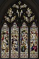 East window, St Denys church, Aswarby - geograph.org.uk - 6076635.jpg 3,204 × 4,851; 7.56 MB
-
 Farm track and drain - geograph.org.uk - 3477246.jpg 2,256 × 1,504; 2.57 MB
-
 Farm track off Mareham Lane - geograph.org.uk - 2924298.jpg 640 × 480; 111 KB
-
 Farmland and Track off Back Lane - geograph.org.uk - 2878943.jpg 1,280 × 853; 400 KB
-
 Farmland south of Aswarby - geograph.org.uk - 3699149.jpg 800 × 586; 114 KB
-

-
 Farmland west of the A15 - geograph.org.uk - 3699184.jpg 640 × 557; 48 KB
-
 Farmland, Barrow Hill - geograph.org.uk - 3699176.jpg 640 × 507; 56 KB
-
 Fingerpost at Swarby turn - geograph.org.uk - 4291380.jpg 960 × 1,280; 1.02 MB
-
 Folkingham 5 - geograph.org.uk - 2869024.jpg 768 × 1,024; 397 KB
-
 Footpath to Silk Willoughby - geograph.org.uk - 5299229.jpg 1,024 × 768; 127 KB
-
 Former blacksmiths, Aswarby - geograph.org.uk - 6214481.jpg 1,024 × 733; 188 KB
-
 Former Well Head (geograph 7073090).jpg 3,944 × 5,293; 7.31 MB
-
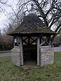
 Former well head, The Green, Swarby - geograph.org.uk - 5303984.jpg 1,024 × 768; 335 KB
-
 Gorse Lane, towards Scredington - geograph.org.uk - 5223797.jpg 640 × 427; 39 KB
-
 Grass field by Orchard Cottage - geograph.org.uk - 5304442.jpg 1,024 × 768; 236 KB
-
 Green Road - geograph.org.uk - 5001263.jpg 4,608 × 3,456; 3.4 MB
-

-
 If you go down in the woods - geograph.org.uk - 6200304.jpg 4,608 × 3,456; 5.85 MB
-
 It's a sign^ - geograph.org.uk - 6200296.jpg 4,608 × 3,456; 5.71 MB
-
 Junction of Back Lane and A15 - geograph.org.uk - 2878929.jpg 1,280 × 853; 331 KB
-

-
 Junction of Green road and Culverthorpe Road - geograph.org.uk - 3802697.jpg 3,088 × 2,056; 3.29 MB
-
 Junction on Mareham Lane - geograph.org.uk - 4512044.jpg 4,272 × 2,848; 5.06 MB
-
 Lane by the churchyard, Swarby - geograph.org.uk - 5304041.jpg 1,024 × 768; 172 KB
-
 Lane heading south west - geograph.org.uk - 3850070.jpg 640 × 480; 81 KB
-
 Lane junction with Mareham Lane - geograph.org.uk - 3850068.jpg 640 × 480; 48 KB
-
 Look north - geograph.org.uk - 6200300.jpg 4,608 × 3,456; 4.55 MB
-
 Looking towards Orchard Cottage from Swarby Lane - geograph.org.uk - 6368999.jpg 1,024 × 768; 239 KB
-
 Manor Farmhouse, Swarby - geograph.org.uk - 5303988.jpg 1,024 × 768; 164 KB
-
 Mareham Lane - geograph.org.uk - 4421514.jpg 1,024 × 683; 252 KB
-

-
 Memorial to George Bass - geograph.org.uk - 6076950.jpg 2,784 × 4,176; 2.89 MB
-
 Milepost - geograph.org.uk - 2869028.jpg 1,024 × 768; 318 KB
-
 Oh deer - geograph.org.uk - 6200323.jpg 4,608 × 3,456; 4.75 MB
-
 Oilseed rape - geograph.org.uk - 4421521.jpg 1,024 × 685; 304 KB
-

-
 Parkland - geograph.org.uk - 6303863.jpg 640 × 480; 89 KB
-
 Parkland at Aswarby - geograph.org.uk - 5174069.jpg 800 × 600; 140 KB
-

-
 Ripening barley near Aswarby - geograph.org.uk - 6199987.jpg 1,024 × 768; 148 KB
-
 Road into Aswarby - geograph.org.uk - 5174064.jpg 800 × 600; 138 KB
-
 Road through Aswarby Park - geograph.org.uk - 5222558.jpg 427 × 640; 142 KB
-
 Road to Aswarby - geograph.org.uk - 3478183.jpg 2,256 × 1,504; 2.29 MB
-
 Road to Aswarby off the A15 - geograph.org.uk - 1548306.jpg 640 × 425; 104 KB
-
 South door, St Denys church, Aswarby - geograph.org.uk - 6076960.jpg 3,694 × 5,204; 5.5 MB
-
 South Lodge, Aswarby Park (geograph 6199983).jpg 1,024 × 768; 257 KB
-
 Speed camera on the A15 - geograph.org.uk - 5210887.jpg 1,600 × 978; 323 KB
-
 St Denys - geograph.org.uk - 6200321.jpg 4,608 × 3,456; 4.16 MB
-

-
 Straight ahead here - geograph.org.uk - 6200313.jpg 4,608 × 3,456; 4.37 MB
-
 Stubble field and houses on Back Lane, Swarby - geograph.org.uk - 6368995.jpg 1,024 × 768; 167 KB
-
 Swarby turn on the A15 - geograph.org.uk - 4291385.jpg 1,280 × 866; 459 KB
-
 The Elms (geograph 7555283).jpg 3,681 × 2,457; 2.35 MB
-
 The junction of Green Road with Culverthorpe Road - geograph.org.uk - 5001269.jpg 4,608 × 3,456; 3.39 MB
-
 The North Beck at Swarby - geograph.org.uk - 5299211.jpg 1,024 × 768; 323 KB
-
 The North Beck at Swarby - geograph.org.uk - 5304036.jpg 1,024 × 768; 221 KB
-
 The road to Aswarby - geograph.org.uk - 2239560.jpg 800 × 600; 290 KB
-
 The south east corner of the churchyard, Swarby - geograph.org.uk - 5304015.jpg 1,024 × 768; 264 KB
-
 Thorns Farm (geograph 7555287).jpg 3,549 × 2,369; 1.85 MB
-
 Track along Aswarby Thorns - geograph.org.uk - 2759816.jpg 1,280 × 853; 316 KB
-
 View from the churchyard, Swarby - geograph.org.uk - 5304018.jpg 1,024 × 768; 219 KB
-
 View towards Swarby Grose - geograph.org.uk - 5304439.jpg 1,024 × 768; 222 KB
-
 Walled garden at Aswarby - geograph.org.uk - 5222552.jpg 640 × 427; 105 KB


_-_geograph.org.uk_-_6360376.jpg)
_-_geograph.org.uk_-_6360388.jpg)


.jpg)


.jpg)


.jpg)


.jpg)


