Category:Atigun River (Alaska)
Jump to navigation
Jump to search
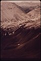
| The Atigun River heads at glacier terminus in Endicott Moutains, then flows 20 miles northeast to Sagavanirktok River, south of its junction with Ribdon River, Brooks Range. Its Eskimo name was reported in 1956 by U.S. Geological Survey (USGS). |
left tributary of Sagavanirktok River in Alaska .jpg) | |||||
| Upload media | |||||
| Instance of | |||||
|---|---|---|---|---|---|
| Location |
| ||||
| Length |
| ||||
| Mouth of the watercourse |
| ||||
 | |||||
Media in category "Atigun River (Alaska)"
The following 7 files are in this category, out of 7 total.
-

-

-
 Atigun River (51358451349).jpg 8,192 × 4,608; 26.1 MB
-

-
-

-


_IN_THIS_VIEW_SOUTH_FROM_A_POINT_NORTH_OF_THE..._-_NARA_-_550500.jpg)
._IN_THE_VIEW_SOUTH_FROM_A_POINT_NORTH_OF_THE..._-_NARA_-_550502.jpg)

,_MUCH_OF_THE_SOUTHERN_HALF_ON_THE_ATIGUN_VALLEY_IS_VISIBLE...._-_NARA_-_550499.jpg)