Category:Atlases of the United States
Jump to navigation
Jump to search
Subcategories
This category has the following 28 subcategories, out of 28 total.
Media in category "Atlases of the United States"
The following 14 files are in this category, out of 14 total.
-
 Atlas of Baltimore County, Maryland 1915 - Plate 9, Part of 1st and 2nd Districts.png 8,194 × 5,675; 19.39 MB
-
 Atlas of climatic types in the United States, 1900-1939 (IA atlasofclimatict421thor 0).pdf 143 × 197, 60 pages; 11.68 MB
-
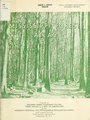 Mississippi forest atlas (IA CAT10503859).pdf 1,179 × 1,566, 56 pages; 3.35 MB
-
-
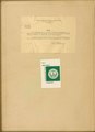
 Forest atlas of the national forests of the United States. Wyoming folio (IA CAT31302102).pdf 143 × 197, 32 pages; 354.34 MB
-
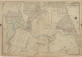
 Combination atlas map of Delaware County, Pennsylvania LOC 2008622015-2.jpg 2,304 × 2,711; 867 KB
-
-
 A list of geographical atlases in the Library of Congress, with bibliographical notes (IA listofgeographic03libr).pdf 1,012 × 1,510, 1,182 pages; 57.54 MB
-
 A list of geographical atlases in the Library of Congress, with bibliographical notes (IA listofgeographic04libr).pdf 793 × 1,366, 816 pages; 48.28 MB
-
 Robinson's Atlas of the City of Newark New Jersey, Volume 3 (1927).djvu 1,042 × 1,500, 36 pages; 8.43 MB
-
 Robinson's Atlas of the City of Newark New Jersey, Volume 3, 1927.pdf 1,500 × 2,158, 36 pages; 9.27 MB
-
 Statistics of Population. (History) NYPL1633809.tiff 5,428 × 6,820; 105.91 MB
-
 Table of Contents. NYPL1583105.tiff 5,414 × 6,542; 101.34 MB
-
 Table of Contents. NYPL1602988.tiff 5,428 × 7,230; 112.28 MB


