Category:Auferstehungskirche (Rathenow)
Jump to navigation
Jump to search
| Object location | | View all coordinates using: OpenStreetMap |
|---|
 | |||||
| Upload media | |||||
| Instance of | |||||
|---|---|---|---|---|---|
| Location | Rathenow, Havelland District, Brandenburg, Germany | ||||
| Heritage designation | |||||
 | |||||
This is the category of the Brandenburger Baudenkmal (cultural heritage monument) with the ID 09150472 (Wikidata)
|
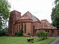
Deutsch: Die Auferstehungskirche in Rathenow, Havelland, Mark Brandenburg, gehört und dient einer lutherischen Gemeinde der unierten Evangelischen Kirche Berlin-Brandenburg-Schlesische Oberlausitz.
English: The Resurrection Church in Rathenow, Havel Land, March of Brandenburg, Germany, is owned and used by a Lutheran congregation within the Evangelical Church of Berlin-Brandenburg-Silesian Upper Lusatia, a united Protestant church body of Calvinist, Lutheran and united congregations.
Français : Église de la Resurrection, ville de Rathenow, arrondissement Pays de la Havel, état fédéral de Brandebourg, Allemagne
Media in category "Auferstehungskirche (Rathenow)"
The following 5 files are in this category, out of 5 total.
-
 Auferstehungskirche Friedhof Rathenow.jpg 2,464 × 1,790; 4.03 MB
-
 Auferstehungskirche Rathenow (1).jpg 4,624 × 2,604; 4.93 MB
-
 Auferstehungskirche Rathenow (2).jpg 4,000 × 2,252; 3.85 MB
-
 Auferstehungskirche Rathenow (3).jpg 4,000 × 2,252; 3.35 MB
-
 Friedhofskapelle Rathenow.jpg 800 × 599; 166 KB
.jpg)
.jpg)
.jpg)

Categories:
- Churches in Rathenow
- Cultural heritage monuments in Rathenow
- Evangelischer Friedhof (Rathenow)
- Cemetery chapels in Brandenburg
- Churches of the Resurrection of Christ in Brandenburg
- Churches in Kirchenkreis Nauen-Rathenow
- Lutheran churches in Brandenburg
- Churches in Brandenburg built in 1917
- 1910s brick churches in Brandenburg
- Curt Steinberg