Category:Balloerkuil Rolde
Jump to navigation
Jump to search
| Object location | | View all coordinates using: OpenStreetMap |
|---|
 | |||||
| Upload media | |||||
| Instance of | |||||
|---|---|---|---|---|---|
| Location | Rolde, Drenthe, Netherlands | ||||
| Heritage designation |
| ||||
 | |||||
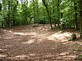
Nederlands: Balloerkuil. Oude gerechtsplaats van Balloo en vergaderplaats van de Etstoel, het vroegere landgericht van Drenthe.
|
This is a category about rijksmonument number 32697
|
| Address |
|
Media in category "Balloerkuil Rolde"
The following 3 files are in this category, out of 3 total.
-
 Balloërkuil - Rolde - 20190064 - RCE.jpg 1,200 × 1,200; 391 KB
-
 Rechtspraak, SFA022824542.jpg 3,583 × 2,542; 1.52 MB
-
 Rolde Balloërkuil.JPG 4,000 × 3,000; 6.88 MB

