Category:Banktunnel
Jump to navigation
Jump to search
| Object location | | View all coordinates using: OpenStreetMap |
|---|
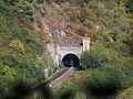
Deutsch: Banktunnel. 366,82 m langer Tunnel der linksrheinischen Eisenbahntrasse bei Sankt Goar, entstanden 1858-59. Inbetriebnahme war am 15. Dezember 1859.
Media in category "Banktunnel"
The following 7 files are in this category, out of 7 total.
-
 Banktunnel 2022a.jpg 4,000 × 3,000; 4.5 MB
-
 Elektrolokomotive der Baureihe 103 tunnel - IC-515-Senator.jpg 3,054 × 2,048; 516 KB
-
 Rhein lastkahn (Rhine barge) - geo.hlipp.de - 36049.jpg 640 × 427; 103 KB
-
 Transregio460Banktunnel.JPG 2,560 × 1,712; 2.25 MB
-
 Tunnel eingang von Linke Rheinstrecke Bild 2.JPG 4,608 × 3,456; 2.91 MB
-
 Tunnel eingang von Linke Rheinstrecke.JPG 4,608 × 3,456; 2.95 MB
-
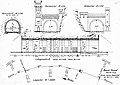 Zeichnung Bank-Tunnel.jpg 6,777 × 4,804; 1.61 MB


_-_geo.hlipp.de_-_36049.jpg)


