Category:Banna (Birdoswald)
Jump to navigation
Jump to search
Roman fort in Cumbria, England  Pevnost Banna (Birdoswald) | |||||
| Upload media | |||||
| Instance of | |||||
|---|---|---|---|---|---|
| Part of |
| ||||
| Location | Waterhead, Carlisle, Cumbria, North West England, England | ||||
| Located in or next to body of water | |||||
| Owned by | |||||
| Operator | |||||
| Different from | |||||
| official website | |||||
 | |||||

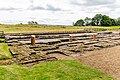
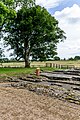
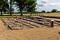
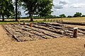
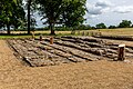
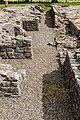
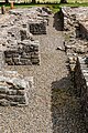
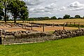
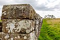
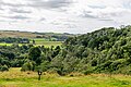
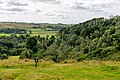
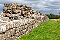
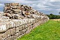
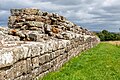
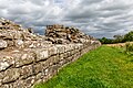
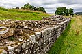
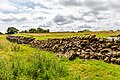
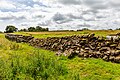
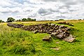
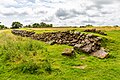
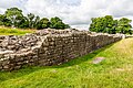
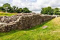
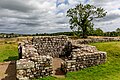
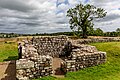
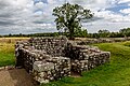
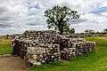
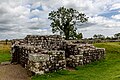
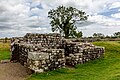
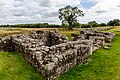
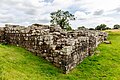
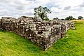
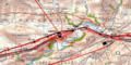
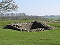
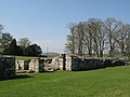
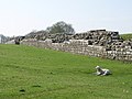
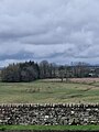
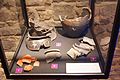
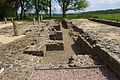
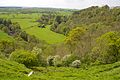
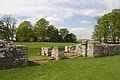
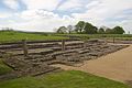
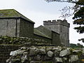
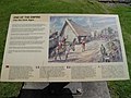
English: Banna, now known as Birdoswald Roman Fort, was a fort, towards the western end of Hadrian's Wall, in the Roman province of Britannia. Today the site is occupied by a former farm called Birdoswald. It is one of the best preserved of the 16 forts along Hadrian's Wall. The fort is situated in a commanding position on a triangular spur of land bounded by cliffs to the south and east overlooking a broad meander of the River Irthing in Cumbria. In Roman times, the fort was known as Banna (Latin for "spur" or "tongue"), reflecting the geography of the site.
Media in category "Banna (Birdoswald)"
The following 200 files are in this category, out of 203 total.
(previous page) (next page)-
 BP Kastell Birdoswald.png 1,050 × 1,420; 537 KB
-
 20210814 Birdoswald-8520.jpg 5,760 × 3,840; 18.43 MB
-
 20210814 Birdoswald-8521.jpg 5,703 × 3,802; 14.17 MB
-
 20210814 Birdoswald-8523.jpg 5,760 × 3,840; 18.18 MB
-
 20210814 Birdoswald-8524.jpg 5,668 × 3,779; 17.3 MB
-
 20210814 Birdoswald-8525.jpg 5,760 × 3,840; 18.59 MB
-
 20210814 Birdoswald-8526.jpg 5,760 × 3,840; 18.99 MB
-
 20210814 Birdoswald-8527.jpg 5,760 × 3,840; 19.38 MB
-
 20210814 Birdoswald-8528.jpg 5,760 × 3,840; 17.24 MB
-
 20210814 Birdoswald-8529.jpg 3,840 × 5,760; 21.37 MB
-
 20210814 Birdoswald-8530.jpg 3,840 × 5,760; 21.63 MB
-
 20210814 Birdoswald-8532.jpg 5,560 × 3,707; 13.1 MB
-
 20210814 Birdoswald-8533.jpg 5,617 × 3,745; 13.26 MB
-
 20210814 Birdoswald-8534.jpg 5,760 × 3,840; 15.56 MB
-
 20210814 Birdoswald-8535.jpg 5,760 × 3,840; 16.24 MB
-
 20210814 Birdoswald-8536.jpg 5,760 × 3,840; 22.41 MB
-
 20210814 Birdoswald-8537.jpg 5,760 × 3,840; 22.87 MB
-
 20210814 Birdoswald-8538.jpg 5,760 × 3,840; 22.6 MB
-
 20210814 Birdoswald-8539.jpg 3,751 × 5,626; 15.69 MB
-
 20210814 Birdoswald-8540.jpg 3,840 × 5,760; 15.85 MB
-
 20210814 Birdoswald-8541.jpg 5,760 × 3,840; 19.72 MB
-
 20210814 Birdoswald-8542.jpg 5,760 × 3,840; 19.76 MB
-
 20210814 Birdoswald-8543.jpg 5,760 × 3,840; 19.88 MB
-
 20210814 Birdoswald-8544.jpg 5,760 × 3,840; 19.82 MB
-
 20210814 Birdoswald-8545.jpg 5,760 × 3,840; 13.96 MB
-
 20210814 Birdoswald-8546.jpg 5,760 × 3,840; 14.06 MB
-
 20210814 Birdoswald-8547.jpg 5,760 × 3,840; 12.05 MB
-
 20210814 Birdoswald-8548.jpg 5,760 × 3,840; 14.64 MB
-
 20210814 Birdoswald-8549.jpg 5,760 × 3,840; 13.78 MB
-
 20210814 Birdoswald-8550.jpg 5,760 × 3,840; 14.32 MB
-
 20210814 Birdoswald-8551.jpg 5,760 × 3,840; 14.69 MB
-
 20210814 Birdoswald-8552.jpg 5,760 × 3,840; 16.79 MB
-
 20210814 Birdoswald-8553.jpg 5,760 × 3,840; 20.73 MB
-
 20210814 Birdoswald-8554.jpg 5,760 × 3,840; 12.71 MB
-
 20210814 Birdoswald-8555.jpg 5,760 × 3,840; 12.18 MB
-
 20210814 Birdoswald-8556.jpg 5,760 × 3,840; 11.53 MB
-
 20210814 Birdoswald-8557.jpg 5,760 × 3,840; 12.6 MB
-
 20210814 Birdoswald-8558.jpg 5,760 × 3,840; 12.38 MB
-
 20210814 Birdoswald-8559.jpg 5,760 × 3,840; 13 MB
-
 20210814 Birdoswald-8560.jpg 5,760 × 3,840; 14.38 MB
-
 20210814 Birdoswald-8561.jpg 5,760 × 3,840; 14.35 MB
-
 20210814 Birdoswald-8562.jpg 5,760 × 3,840; 14.51 MB
-
 20210814 Birdoswald-8563.jpg 5,760 × 3,840; 16.77 MB
-
 20210814 Birdoswald-8564.jpg 5,760 × 3,840; 15.31 MB
-
 20210814 Birdoswald-8565.jpg 5,760 × 3,840; 15.31 MB
-
 20210814 Birdoswald-8566.jpg 5,760 × 3,840; 17.38 MB
-
 20210814 Birdoswald-8567.jpg 5,760 × 3,840; 17.74 MB
-
 20210814 Birdoswald-8568.jpg 5,760 × 3,840; 20.42 MB
-
 20210814 Birdoswald-8569.jpg 5,760 × 3,840; 20.55 MB
-
 20210814 Birdoswald-8570.jpg 5,760 × 3,840; 21.46 MB
-
 20210814 Birdoswald-8571.jpg 5,760 × 3,840; 20.37 MB
-
 20210814 Birdoswald-8572.jpg 5,760 × 3,840; 21.69 MB
-
 20210814 Birdoswald-8573.jpg 5,760 × 3,840; 23.48 MB
-
 20210814 Birdoswald-8574.jpg 5,760 × 3,840; 23.96 MB
-
 20210814 Birdoswald-8575.jpg 5,760 × 3,840; 20.85 MB
-
 20210814 Birdoswald-8576.jpg 5,760 × 3,840; 20.65 MB
-
 20210814 Birdoswald-8577.jpg 5,760 × 3,840; 21 MB
-
 20210814 Birdoswald-8578.jpg 5,760 × 3,840; 18.58 MB
-
 20210814 Birdoswald-8579.jpg 5,760 × 3,840; 18.64 MB
-
 20210814 Birdoswald-8580.jpg 5,760 × 3,840; 17.85 MB
-
 20210814 Birdoswald-8581.jpg 5,760 × 3,840; 17.74 MB
-
 20210814 Birdoswald-8582.jpg 5,760 × 3,840; 18.72 MB
-
 20210814 Birdoswald-8583.jpg 5,760 × 3,840; 18.73 MB
-
 20210814 Birdoswald-8584.jpg 5,760 × 3,840; 17.5 MB
-
 20210814 Birdoswald-8585.jpg 5,760 × 3,840; 15.75 MB
-
 20210814 Birdoswald-8586.jpg 5,760 × 3,840; 15.16 MB
-
 20210814 Birdoswald-8587.jpg 5,760 × 3,840; 15.9 MB
-
 20210814 Birdoswald-8588.jpg 5,760 × 3,840; 16.91 MB
-
 20210814 Birdoswald-8589.jpg 5,760 × 3,840; 17.05 MB
-
 20210814 Birdoswald-8590.jpg 5,760 × 3,840; 17.77 MB
-
 20210814 Birdoswald-8591.jpg 5,760 × 3,840; 18.97 MB
-
 20210814 Birdoswald-8592.jpg 5,760 × 3,840; 18.76 MB
-
 20210814 Birdoswald-8593.jpg 5,760 × 3,840; 19.01 MB
-
 20210814 Birdoswald-8594.jpg 5,760 × 3,840; 18.07 MB
-
 20210814 Birdoswald-8595.jpg 5,760 × 3,840; 18.79 MB
-
 20210814 Birdoswald-8596.jpg 5,760 × 3,840; 18.06 MB
-
 20210814 Birdoswald-8597.jpg 5,760 × 3,840; 18.48 MB
-
 20210814 Birdoswald-8598.jpg 5,760 × 3,840; 18.52 MB
-
 20210814 Birdoswald-8599.jpg 5,760 × 3,840; 18.64 MB
-
 20210814 Birdoswald-8600.jpg 5,760 × 3,840; 19.04 MB
-
 20210814 Birdoswald-8601.jpg 5,760 × 3,840; 19.08 MB
-
 20210814 Birdoswald-8602.jpg 5,760 × 3,840; 18.78 MB
-
 20210814 Birdoswald-8604.jpg 3,840 × 5,760; 12.78 MB
-
 20210814 Birdoswald-8605.jpg 3,840 × 5,760; 12.96 MB
-

-
 Banna map.png 1,200 × 600; 1.87 MB
-
 Bauinschrift der Legio VI Birdoswald.png 644 × 530; 63 KB
-
 Birdoswald (Banna) - geograph.org.uk - 1357934.jpg 640 × 480; 90 KB
-
-
 Birdoswald (Banna) - the east wall - geograph.org.uk - 1359198.jpg 640 × 480; 75 KB
-

-

-

-

-
-

-
 Birdoswald (Banna) - the south gate - geograph.org.uk - 1357957.jpg 640 × 480; 72 KB
-

-
-

-

-
 Birdoswald (Banna) and lamb - geograph.org.uk - 1357991.jpg 640 × 480; 128 KB
-
 Birdoswald (Samian Ware Discovery Site).jpg 3,000 × 4,000; 1.8 MB
-
 Birdoswald - geograph.org.uk - 1357892.jpg 640 × 480; 85 KB
-
 Birdoswald - northwest corner - geograph.org.uk - 1357920.jpg 640 × 480; 125 KB
-

-
 Birdoswald 2014 01.jpg 5,184 × 3,456; 4.95 MB
-
 Birdoswald 2014 02.jpg 3,456 × 5,184; 7.28 MB
-
 Birdoswald 2014 03.jpg 3,456 × 5,184; 6.97 MB
-
 Birdoswald 2014 04.jpg 3,046 × 4,226; 3.4 MB
-
 Birdoswald 2014 05.jpg 3,133 × 3,023; 1.94 MB
-
 Birdoswald 2014 06.jpg 5,184 × 3,456; 4.74 MB
-
 Birdoswald 2014 07.jpg 5,184 × 3,456; 4.5 MB
-
 Birdoswald 2014 08.jpg 5,184 × 3,456; 6.51 MB
-
 Birdoswald 2014 09.jpg 5,184 × 3,456; 6.79 MB
-
 Birdoswald 2014 10.jpg 5,184 × 3,456; 5.89 MB
-
 Birdoswald 2014 11.jpg 5,184 × 3,456; 4.81 MB
-
 Birdoswald 2014 12.jpg 5,184 × 3,456; 7.6 MB
-
 Birdoswald 2014 13.jpg 5,184 × 3,456; 8.07 MB
-
 Birdoswald 2014 14.jpg 3,456 × 5,184; 6.46 MB
-
 Birdoswald 2014 15.jpg 5,184 × 3,456; 7.6 MB
-
 Birdoswald 2014 16.jpg 5,184 × 3,456; 5.62 MB
-
 Birdoswald 2014 17.jpg 5,184 × 3,456; 5.95 MB
-
 Birdoswald 2014 18.jpg 5,184 × 3,456; 5.06 MB
-
 Birdoswald 2014 19.jpg 5,184 × 3,456; 6.07 MB
-
 Birdoswald 2014 20.jpg 5,184 × 3,456; 4.71 MB
-
 Birdoswald 2014 21.jpg 5,184 × 3,456; 5.24 MB
-
 Birdoswald 2014 22.jpg 5,184 × 3,456; 5.61 MB
-
 Birdoswald 2014 23.jpg 5,184 × 3,456; 6.06 MB
-
 Birdoswald 2014 24.jpg 5,184 × 3,456; 4.72 MB
-
 Birdoswald 2014 25.jpg 5,184 × 3,456; 5.03 MB
-
 Birdoswald 2014 26.jpg 5,184 × 3,456; 7.06 MB
-
 Birdoswald 2014 27.jpg 5,184 × 3,456; 5.64 MB
-
 Birdoswald 2014 28.jpg 5,184 × 3,456; 5.74 MB
-
 Birdoswald 2014 29.jpg 5,184 × 3,456; 5.24 MB
-
 Birdoswald 2014 30.jpg 5,184 × 3,456; 5.55 MB
-
 Birdoswald eastern wall.JPG 3,968 × 2,976; 2.16 MB
-
 Birdoswald Roman Fort - geograph.org.uk - 1012553.jpg 640 × 480; 91 KB
-
 Birdoswald Roman Fort - geograph.org.uk - 1289940.jpg 640 × 480; 69 KB
-
 Birdoswald Roman Fort - geograph.org.uk - 17585.jpg 640 × 480; 60 KB
-

-
 Birdoswald Roman Fort east gate.JPG 2,976 × 3,968; 2.74 MB
-
 Birdoswald Roman Fort Stone.jpg 2,976 × 3,968; 2.33 MB
-
 Birdoswald Roman Fort's Victorian Building.JPG 3,968 × 2,976; 2.12 MB
-
 Birdoswald Roman Fort, Hadrians Wall (8750214407).jpg 4,288 × 3,216; 5.76 MB
-
 Birdoswald Roman Fort, Hadrians Wall (8750217445).jpg 4,288 × 3,216; 5.21 MB
-
 Birdoswald Roman Fort, Hadrians Wall (8750218221).jpg 4,288 × 3,216; 4.99 MB
-
 Birdoswald Roman Fort, Hadrians Wall (8750219953).jpg 4,288 × 3,216; 5.55 MB
-
 Birdoswald Roman Fort, Hadrians Wall (8750221115).jpg 4,288 × 3,216; 5.56 MB
-
 Birdoswald Roman Fort, Hadrians Wall (8750224291).jpg 3,216 × 4,288; 5.69 MB
-
 Birdoswald Roman Fort, Hadrians Wall (8750225685).jpg 4,288 × 3,216; 5.34 MB
-
 Birdoswald Roman Fort, Hadrians Wall (8750228259).jpg 4,288 × 3,216; 5.55 MB
-
 Birdoswald Roman Fort, Hadrians Wall (8750229011).jpg 4,288 × 3,216; 5.75 MB
-
 Birdoswald Roman Fort, Hadrians Wall (8750234221).jpg 4,288 × 3,216; 6 MB
-
 Birdoswald Roman Fort, Hadrians Wall (8750236707).jpg 4,288 × 3,216; 5.78 MB
-
 Birdoswald Roman Fort, Hadrians Wall (8750239547).jpg 4,288 × 3,216; 6.02 MB
-
 Birdoswald Roman Fort, Hadrians Wall (8750241439).jpg 4,288 × 3,216; 5.13 MB
-
 Birdoswald Roman Fort, Hadrians Wall (8751336258).jpg 4,288 × 3,216; 5.56 MB
-
 Birdoswald Roman Fort, Hadrians Wall (8751339224).jpg 4,288 × 3,216; 5.34 MB
-
 Birdoswald Roman Fort, Hadrians Wall (8751341028).jpg 4,288 × 3,216; 5.19 MB
-
 Birdoswald Roman Fort, Hadrians Wall (8751342772).jpg 4,288 × 3,216; 6.01 MB
-
 Birdoswald Roman Fort, Hadrians Wall (8751344258).jpg 4,288 × 3,216; 5.51 MB
-
 Birdoswald Roman Fort, Hadrians Wall (8751347310).jpg 4,288 × 3,216; 5.72 MB
-
 Birdoswald Roman Fort, Hadrians Wall (8751349824).jpg 4,288 × 3,216; 5.81 MB
-
 Birdoswald Roman Fort, Hadrians Wall (8751351782).jpg 4,288 × 3,216; 5.66 MB
-
 Birdoswald Roman Fort, Hadrians Wall (8751352376).jpg 4,288 × 3,216; 5.55 MB
-
 Birdoswald Roman Fort, Hadrians Wall (8751355808).jpg 4,288 × 3,216; 5.35 MB
-
 Birdoswald Roman Fort, Hadrians Wall (8751355864).jpg 4,288 × 3,216; 5.31 MB
-
 Birdoswald Roman Fort, Hadrians Wall (8751356674).jpg 4,288 × 3,216; 5.54 MB
-
 Birdoswald Roman Fort, Hadrians Wall (8751358564).jpg 3,216 × 4,288; 5.99 MB
-
 Birdoswald Roman Fort, Hadrians Wall (8751359122).jpg 4,288 × 3,216; 6.01 MB
-
 Birdoswald Roman Fort, Hadrians Wall (8751361446).jpg 4,288 × 3,216; 5.79 MB
-
 Birdoswald Roman Fort, Hadrians Wall (8751362510).jpg 4,288 × 3,216; 5.81 MB
-
 Birdoswald Roman Fort, Hadrians Wall (8751363462).jpg 4,288 × 3,216; 5.79 MB
-
 Birdoswald Roman Fort, Hadrians Wall (8751365860).jpg 4,288 × 3,216; 5.7 MB
-
 Birdoswald Roman Fort, Hadrians Wall (8751365864).jpg 4,288 × 3,216; 5.77 MB
-
 Centurialstone CB Cilurnum .png 1,161 × 614; 38 KB
-

-
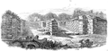
 East Gate Birdoswald newly uncovered J. Storey 1855.png 294 × 368; 209 KB
-
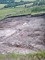 Excavations north of Birdoswald Roman Fort, Hadrian's Wall, Cumbria (July 2023) 01.jpg 1,940 × 2,587; 1.98 MB
-
 Excavations north of Birdoswald Roman Fort, Hadrian's Wall, Cumbria (July 2023) 02.jpg 1,849 × 2,466; 1.56 MB
-
 Excavations north of Birdoswald Roman Fort, Hadrian's Wall, Cumbria (July 2023) 03.jpg 1,687 × 2,249; 1.48 MB
-
 Excavations west of Birdoswald Roman Fort, Hadrian's Wall, Cumbria (July 2023).jpg 1,940 × 1,455; 675 KB
-
 Gateway of Amboglanna - H G Hine.png 1,000 × 476; 644 KB
-
 Granaries, Birdoswald Roman Fort, Hadrians Wall (8750223693).jpg 4,288 × 3,216; 5.87 MB
-

-
 Hadrian's Wall and Birdoswald - geograph.org.uk - 1357884.jpg 640 × 480; 91 KB
-
 Hadrian's Wall and Birdoswald Fort - geograph.org.uk - 1012543.jpg 640 × 480; 107 KB
-
 Hadrian's Wall at Birdoswald - geograph.org.uk - 552095.jpg 640 × 480; 145 KB
-
 Hadrian's Wall east of Birdoswald - geograph.org.uk - 947201.jpg 640 × 437; 57 KB
-

-

-

-
 Hadrian's Wall west of Birdoswald (2b) - geograph.org.uk - 1357856.jpg 640 × 480; 100 KB
-

-
 Hadrian's Wall west of Birdoswald - geograph.org.uk - 1357729.jpg 480 × 640; 97 KB
-
 HadriansWallNearBirdoswald01.jpg 3,072 × 2,304; 611 KB
-
 Ruins of Birdoswald Roman Fort.jpg 640 × 480; 68 KB
-

-
 Sitzstatue d. Fortuna Birdoswald.png 728 × 1,204; 155 KB


_-_geograph.org.uk_-_1357934.jpg)
_-_part_of_the_main_east_gate_-_geograph.org.uk_-_1357962.jpg)
_-_the_east_wall_-_geograph.org.uk_-_1359198.jpg)
_-_the_east_wall_and_gate_(2)_-_geograph.org.uk_-_1357975.jpg)
_-_the_east_wall_and_gate_(3)_-_geograph.org.uk_-_1370935.jpg)
_-_the_east_wall_and_gate_-_geograph.org.uk_-_1357969.jpg)
_-_the_east_wall_and_lamb_-_geograph.org.uk_-_1359046.jpg)
_-_the_main_east_gate_(2)_-_geograph.org.uk_-_1357983.jpg)
_-_the_main_east_gate_-_geograph.org.uk_-_1357951.jpg)
_-_the_south_gate_-_geograph.org.uk_-_1357957.jpg)
_-_the_south_gate_and_wall_-_geograph.org.uk_-_1370922.jpg)
_-_the_south_wall_and_lamb_-_geograph.org.uk_-_1359189.jpg)
_-_the_southeast_angle_tower_and_lamb_-_geograph.org.uk_-_1359179.jpg)
_-_the_west_wall_and_modern_farm_buildings_-_geograph.org.uk_-_1370949.jpg)
_and_lamb_-_geograph.org.uk_-_1357991.jpg)
.jpg)


.jpg)
.jpg)
.jpg)
.jpg)
.jpg)
.jpg)
.jpg)
.jpg)
.jpg)
.jpg)
.jpg)
.jpg)
.jpg)
.jpg)
.jpg)
.jpg)
.jpg)
.jpg)
.jpg)
.jpg)
.jpg)
.jpg)
.jpg)
.jpg)
.jpg)
.jpg)
.jpg)
.jpg)
.jpg)
.jpg)
.jpg)
.jpg)


_01.jpg)
_02.jpg)
_03.jpg)
.jpg)

.jpg)


_-_geograph.org.uk_-_1357816.jpg)
_-_geograph.org.uk_-_1357856.jpg)
_-_geograph.org.uk_-_1357901.jpg)


&filefrom=South+Gate+Birdoswald+John+Storey+1855.png#mw-category-media)