Category:River Irthing
Jump to navigation
Jump to search

river in the United Kingdom  | |||||
| Upload media | |||||
| Instance of | |||||
|---|---|---|---|---|---|
| Location | Northumberland, North East England, England | ||||
| Length |
| ||||
| Mouth of the watercourse | |||||
| Tributary |
| ||||
 | |||||
Deutsch: Der Irthing ist ein Fluss in Nordengland nahe der schottischen Grenze. Er entspringt nahe dem Berg Black Knowe in den Cheviot Hills (ca. ). Er mündet in der Nähe der Stadt Carlisle in den Fluss Eden. Seine Länge beträgt 55 km. Nach etwa 1/3 seiner Länge durchquert er bei Gilsland den früheren römischen Hadrianswall. (→Irthing)
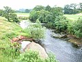
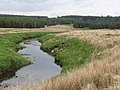
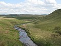
English: The River Irthing is a river in Cumbria, England and a major tributary of the River Eden. The name is recorded as Ard or Arden in early references. For the first 15 miles of its course it defines the border between Northumberland and Cumbria. (→River Irthing)
Français : L’Irthing est une rivière du Royaume-Uni, qui coule dans le comté anglais de Cumbria. Elle est l’un des principaux affluents de l’Eden. (→Irthing)
Русский: Иртинг — река в Великобритании. Протекает на северо-западе Англии в графстве Камбрия. Длина 55 км. В ранних источниках название реки записывалось как «Ard» или «Arden». (→Иртинг)
Subcategories
This category has the following 3 subcategories, out of 3 total.
Media in category "River Irthing"
The following 90 files are in this category, out of 90 total.
-
 An Oxbow of the River Irthing - geograph.org.uk - 1271002.jpg 480 × 640; 53 KB
-
 Another bend in the River Irthing - geograph.org.uk - 882053.jpg 640 × 480; 74 KB
-
 Bell's Braes and the River Irthing - geograph.org.uk - 164230.jpg 640 × 480; 84 KB
-
 Bend in the River Irthing - geograph.org.uk - 881995.jpg 640 × 480; 80 KB
-

-
 Crags above the River Irthing - geograph.org.uk - 889363.jpg 640 × 480; 110 KB
-
 Geological Map Geology Bewcastle Day 1970 06.jpg 2,488 × 3,881; 2.01 MB
-
 Lambs on the wrong side of the river - geograph.org.uk - 889353.jpg 640 × 480; 145 KB
-
 Little Tongue Rigg (from Shank End) - geograph.org.uk - 889311.jpg 640 × 480; 74 KB
-
 Meander in the River Irthing - geograph.org.uk - 891915.jpg 640 × 480; 64 KB
-
 Natural weir on the River Irthing - geograph.org.uk - 883148.jpg 640 × 480; 83 KB
-
 Popping Stone - geograph.org.uk - 296949.jpg 640 × 480; 164 KB
-
 River Irthing - geograph.org.uk - 1413976.jpg 640 × 480; 121 KB
-
 River Irthing - geograph.org.uk - 1485495.jpg 640 × 399; 92 KB
-
 River Irthing - geograph.org.uk - 1607743.jpg 640 × 371; 116 KB
-
 River Irthing - geograph.org.uk - 1607750.jpg 640 × 405; 105 KB
-
 River Irthing - geograph.org.uk - 164215.jpg 640 × 480; 86 KB
-
 River Irthing - geograph.org.uk - 164224.jpg 640 × 480; 76 KB
-
 River Irthing - geograph.org.uk - 207733.jpg 640 × 480; 90 KB
-
 River Irthing - geograph.org.uk - 445851.jpg 427 × 640; 83 KB
-
 River Irthing - geograph.org.uk - 445940.jpg 640 × 427; 127 KB
-
 River Irthing - geograph.org.uk - 461540.jpg 640 × 427; 80 KB
-
 River Irthing - geograph.org.uk - 528350.jpg 640 × 480; 83 KB
-
 River Irthing - geograph.org.uk - 528372.jpg 640 × 373; 89 KB
-
 River Irthing - geograph.org.uk - 947202.jpg 640 × 433; 82 KB
-
 River Irthing at Churnsike - geograph.org.uk - 1746424.jpg 640 × 480; 92 KB
-
 River Irthing from Ruleholme Bridge - geograph.org.uk - 1447419.jpg 640 × 480; 354 KB
-
 River Irthing from Stony Gate - geograph.org.uk - 671228.jpg 640 × 480; 67 KB
-
 River Irthing from Stony Gate - geograph.org.uk - 671239.jpg 640 × 480; 66 KB
-
 River Irthing from Tudhups Holm - geograph.org.uk - 580165.jpg 640 × 428; 99 KB
-
 River Irthing near Lanercost - geograph.org.uk - 445351.jpg 640 × 480; 115 KB
-
 River Irthing west of Wallholme - geograph.org.uk - 1465538.jpg 640 × 368; 87 KB
-
 River Irthing, from Lanercost Old Bridge - geograph.org.uk - 957301.jpg 600 × 450; 146 KB
-
 Road head at Churnsike - geograph.org.uk - 1746417.jpg 640 × 480; 92 KB
-
 Rock outcrop above the River Irthing - geograph.org.uk - 880809.jpg 640 × 480; 97 KB
-

-
 Spy Crags - geograph.org.uk - 672372.jpg 640 × 480; 75 KB
-
 Stepping Stone in the River Irthing - geograph.org.uk - 1741489.jpg 1,731 × 1,181; 407 KB
-
 Stepping Stones over the River Irthing - geograph.org.uk - 785606.jpg 480 × 640; 125 KB
-

-
 The River Irthing (2) - geograph.org.uk - 1554339.jpg 640 × 480; 88 KB
-
 The River Irthing (2) - geograph.org.uk - 838844.jpg 640 × 480; 70 KB
-
 The River Irthing (2) - geograph.org.uk - 891920.jpg 640 × 480; 79 KB
-
 The River Irthing (3) - geograph.org.uk - 838850.jpg 640 × 480; 81 KB
-
 The River Irthing - geograph.org.uk - 1554332.jpg 640 × 480; 126 KB
-
 The River Irthing - geograph.org.uk - 631469.jpg 640 × 480; 94 KB
-
 The River Irthing - geograph.org.uk - 633046.jpg 640 × 480; 85 KB
-
 The River Irthing - geograph.org.uk - 890327.jpg 640 × 480; 82 KB
-
 The River Irthing - geograph.org.uk - 891911.jpg 640 × 480; 76 KB
-
 The River Irthing - geograph.org.uk - 909459.jpg 640 × 480; 84 KB
-
 The River Irthing - geograph.org.uk - 909462.jpg 640 × 480; 62 KB
-
 The River Irthing above Lanercost - geograph.org.uk - 207943.jpg 640 × 480; 75 KB
-
 The River Irthing below Black Spy (2) - geograph.org.uk - 890069.jpg 640 × 480; 77 KB
-
 The River Irthing below Black Spy (3) - geograph.org.uk - 890074.jpg 640 × 480; 84 KB
-
 The River Irthing below Black Spy - geograph.org.uk - 890063.jpg 640 × 480; 80 KB
-

-

-
 The River Irthing near Willowford Bridge - geograph.org.uk - 1359402.jpg 640 × 480; 131 KB
-

-

-
 The River Irthing west of Whitehill - geograph.org.uk - 849668.jpg 640 × 480; 76 KB
-
 The valley of the River Irthing (10) - geograph.org.uk - 883262.jpg 640 × 480; 80 KB
-
 The valley of the River Irthing (11) - geograph.org.uk - 892481.jpg 640 × 480; 80 KB
-
 The valley of the River Irthing (12) - geograph.org.uk - 892484.jpg 640 × 480; 87 KB
-
 The valley of the River Irthing (14) - geograph.org.uk - 892495.jpg 640 × 480; 70 KB
-
 The valley of the River Irthing (2) - geograph.org.uk - 880805.jpg 640 × 480; 94 KB
-
 The valley of the River Irthing (2) - geograph.org.uk - 882409.jpg 640 × 480; 68 KB
-
 The valley of the River Irthing (3) - geograph.org.uk - 880817.jpg 640 × 480; 82 KB
-
 The valley of the River Irthing (3) - geograph.org.uk - 882413.jpg 640 × 480; 69 KB
-
 The valley of the River Irthing (4) - geograph.org.uk - 881934.jpg 640 × 480; 91 KB
-
 The valley of the River Irthing (4) - geograph.org.uk - 883152.jpg 640 × 480; 67 KB
-
 The valley of the River Irthing (5) - geograph.org.uk - 881937.jpg 640 × 480; 93 KB
-
 The valley of the River Irthing (5) - geograph.org.uk - 883161.jpg 640 × 480; 74 KB
-
 The valley of the River Irthing (6) - geograph.org.uk - 881946.jpg 640 × 480; 92 KB
-
 The valley of the River Irthing (6) - geograph.org.uk - 883246.jpg 640 × 480; 61 KB
-
 The valley of the River Irthing (7) - geograph.org.uk - 881991.jpg 640 × 480; 79 KB
-
 The valley of the River Irthing (7) - geograph.org.uk - 883252.jpg 640 × 480; 82 KB
-
 The valley of the River Irthing (8) - geograph.org.uk - 882004.jpg 640 × 480; 76 KB
-
 The valley of the River Irthing (8) - geograph.org.uk - 883255.jpg 640 × 480; 83 KB
-
 The valley of the River Irthing (9) - geograph.org.uk - 882040.jpg 640 × 480; 80 KB
-
 The valley of the River Irthing (9) - geograph.org.uk - 883260.jpg 640 × 480; 82 KB
-

-
 The valley of the River Irthing - geograph.org.uk - 834202.jpg 640 × 480; 75 KB
-
 The valley of the River Irthing - geograph.org.uk - 880801.jpg 640 × 480; 92 KB
-
 The valley of the River Irthing - geograph.org.uk - 882070.jpg 640 × 480; 74 KB
-
 The valley of the River Irthing - geograph.org.uk - 890054.jpg 640 × 480; 80 KB
-

-

-

-
 Derelict Building - geograph.org.uk - 528544.jpg 640 × 480; 91 KB


_-_geograph.org.uk_-_889311.jpg)


_-_geograph.org.uk_-_1554339.jpg)
_-_geograph.org.uk_-_838844.jpg)
_-_geograph.org.uk_-_891920.jpg)
_-_geograph.org.uk_-_838850.jpg)


_-_geograph.org.uk_-_890069.jpg)
_-_geograph.org.uk_-_890074.jpg)


_-_geograph.org.uk_-_849673.jpg)

_-_geograph.org.uk_-_883262.jpg)
_-_geograph.org.uk_-_892481.jpg)
_-_geograph.org.uk_-_892484.jpg)
_-_geograph.org.uk_-_892495.jpg)
_-_geograph.org.uk_-_880805.jpg)
_-_geograph.org.uk_-_882409.jpg)
_-_geograph.org.uk_-_880817.jpg)
_-_geograph.org.uk_-_882413.jpg)
_-_geograph.org.uk_-_881934.jpg)
_-_geograph.org.uk_-_883152.jpg)
_-_geograph.org.uk_-_881937.jpg)
_-_geograph.org.uk_-_883161.jpg)
_-_geograph.org.uk_-_881946.jpg)
_-_geograph.org.uk_-_883246.jpg)
_-_geograph.org.uk_-_881991.jpg)
_-_geograph.org.uk_-_883252.jpg)
_-_geograph.org.uk_-_882004.jpg)
_-_geograph.org.uk_-_883255.jpg)
_-_geograph.org.uk_-_882040.jpg)
_-_geograph.org.uk_-_883260.jpg)
_-_geograph.org.uk_-_887691.jpg)


_-_geograph.org.uk_-_1359310.jpg)


