Category:Barkåkra församlingshem
Jump to navigation
Jump to search
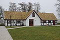
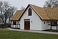
Svenska: Församlingshem söder om Barkåkra kyrka.
| Object location | | View all coordinates using: OpenStreetMap |
|---|
|
This is a category about an ecclesiastical monument in Sweden, number 21300000004221 (sub-number: 21400000440238) in the RAÄ buildings database.
|
Media in category "Barkåkra församlingshem"
The following 4 files are in this category, out of 4 total.
-
 BarkåkraFörsamlingshem2201.jpg 5,184 × 3,456; 7.63 MB
-
 BarkåkraFörsamlingshem2202.jpg 5,184 × 3,456; 7.42 MB
-
 BarkåkraFörsamlingshem2203.jpg 5,184 × 3,456; 7.16 MB
-
 BarkåkraFörsamlingshem2401.jpg 5,184 × 3,456; 9.9 MB


