Category:Barn at Greasby Manor
Jump to navigation
Jump to search
| Object location | | View all coordinates using: OpenStreetMap |
|---|
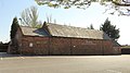
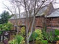
This is a category about listed building number 1242745. |
barn in Wirral, Merseyside, UK  | |||||
| Upload media | |||||
| Instance of | |||||
|---|---|---|---|---|---|
| Location | Wirral, Merseyside, North West England, England | ||||
| Heritage designation |
| ||||
 | |||||
Former barn, now a restaurant and function room for The Manor, Greasby. Dates to early 17th century.
Media in category "Barn at Greasby Manor"
The following 6 files are in this category, out of 6 total.
-
 Gable of barn at Greasby Manor.jpg 4,872 × 3,204; 11.53 MB
-
 North elevation, barn at Greasby Manor 1.jpg 5,010 × 2,793; 10.99 MB
-
 North elevation, barn at Greasby Manor 2.jpg 4,971 × 2,913; 10.48 MB
-
 Rear of Barn, The Manor, Greasby.jpg 5,152 × 3,864; 7.97 MB
-
 The Manor Barn, Greasby (2).jpg 5,152 × 3,864; 7.96 MB
-
 The Manor Barn, Greasby.jpg 5,152 × 3,864; 7.83 MB


.jpg)