Category:Barn at Vineyard Farm, Poulton Lancelyn
Jump to navigation
Jump to search
| Object location | | View all coordinates using: OpenStreetMap |
|---|
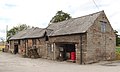
Grade II listed barn in Wirral, Merseyside, England, UK  | |||||
| Upload media | |||||
| Instance of | |||||
|---|---|---|---|---|---|
| Location | Wirral, Merseyside, North West England, England | ||||
| Heritage designation |
| ||||
 | |||||
Media in category "Barn at Vineyard Farm, Poulton Lancelyn"
The following 2 files are in this category, out of 2 total.
-
 Barn at Vineyard Farm, Poulton Lancelyn 1.jpg 5,065 × 3,306; 18.28 MB
-
 Barn at Vineyard Farm, Poulton Lancelyn 2.jpg 4,627 × 2,780; 13.75 MB
