Category:Barnham and Eastergate
Jump to navigation
Jump to search
English: Barnham and Eastergate is a civil parish in the Arun district, in the county of West Sussex, England.
civil parish in Arun, West Sussex, England, UK | |||||
| Upload media | |||||
| Instance of | |||||
|---|---|---|---|---|---|
| Named after | |||||
| Location | Arun, West Sussex, South East England, England | ||||
| Population |
| ||||
 | |||||
Subcategories
This category has the following 2 subcategories, out of 2 total.
B
E
Media in category "Barnham and Eastergate"
The following 189 files are in this category, out of 189 total.
-
 "Stoneblower" at Barnham Junction - geograph.org.uk - 4041853.jpg 640 × 427; 70 KB
-
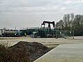 'Nodding Donkey' at Lidsey Oil Field - geograph.org.uk - 2785863.jpg 640 × 480; 91 KB
-
 A new location for an old friend - geograph.org.uk - 2242146.jpg 640 × 480; 95 KB
-
 A scene of Fontwell Race Course - geograph.org.uk - 4565690.jpg 640 × 512; 48 KB
-
 A small stream - geograph.org.uk - 4730337.jpg 640 × 426; 60 KB
-
 A young crop - geograph.org.uk - 4730335.jpg 640 × 426; 47 KB
-
 A29, Eastergate - geograph.org.uk - 5569543.jpg 640 × 426; 59 KB
-
 A29, Fontwell - geograph.org.uk - 5569542.jpg 640 × 426; 66 KB
-
 Arable field - geograph.org.uk - 6575251.jpg 1,024 × 684; 87 KB
-
 Arable land - geograph.org.uk - 4730339.jpg 640 × 426; 51 KB
-
 B2233 - geograph.org.uk - 5569547.jpg 640 × 426; 78 KB
-
 B2233 - geograph.org.uk - 5569555.jpg 640 × 426; 44 KB
-
 Bare, fallow field - geograph.org.uk - 4730330.jpg 640 × 426; 34 KB
-
 Barnham Bridge Inn - geograph.org.uk - 3980980.jpg 1,024 × 768; 109 KB
-
 Barnham Church to Merston Church (1) - geograph.org.uk - 2244113.jpg 640 × 480; 98 KB
-
 Barnham Church to Merston Church (10a) - geograph.org.uk - 2244381.jpg 640 × 480; 116 KB
-
 Barnham Church to Merston Church (10b) - geograph.org.uk - 2244397.jpg 480 × 640; 139 KB
-
 Barnham Church to Merston Church (11) - geograph.org.uk - 2244457.jpg 640 × 480; 115 KB
-

-

-
 Barnham Church to Merston Church (14) - geograph.org.uk - 2244477.jpg 640 × 480; 110 KB
-

-

-
 Barnham Church to Merston Church (17) - geograph.org.uk - 2245754.jpg 640 × 455; 104 KB
-

-
 Barnham Church to Merston Church (18) - geograph.org.uk - 2245761.jpg 640 × 480; 101 KB
-

-
 Barnham Church to Merston Church (2) - geograph.org.uk - 2244132.jpg 640 × 480; 139 KB
-

-
 Barnham Church to Merston Church (3) - geograph.org.uk - 2244149.jpg 640 × 480; 128 KB
-
 Barnham Church to Merston Church (4) - geograph.org.uk - 2244153.jpg 640 × 480; 145 KB
-
 Barnham Church to Merston Church (5) - geograph.org.uk - 2244161.jpg 640 × 480; 155 KB
-
 Barnham Church to Merston Church (6) - geograph.org.uk - 2244167.jpg 640 × 480; 104 KB
-
 Barnham Church to Merston Church (7) - geograph.org.uk - 2244182.jpg 640 × 480; 130 KB
-
 Barnham Church to Merston Church (8) - geograph.org.uk - 2244184.jpg 640 × 480; 142 KB
-
 Barnham Church to Merston Church (9) - geograph.org.uk - 2244190.jpg 640 × 480; 94 KB
-
 Barnham Court - geograph.org.uk - 2785819.jpg 640 × 480; 100 KB
-
 Barnham Court - geograph.org.uk - 5144365.jpg 4,000 × 2,666; 7.77 MB
-
 Barnham Lane - geograph.org.uk - 5629861.jpg 640 × 426; 74 KB
-
 Barnham Rife - geograph.org.uk - 2785836.jpg 640 × 480; 130 KB
-
 Barnham Rife - geograph.org.uk - 2785850.jpg 640 × 480; 102 KB
-
 Barnham Road - geograph.org.uk - 2779828.jpg 640 × 428; 121 KB
-
 Barnham Road at Church Lane junction - geograph.org.uk - 2779854.jpg 640 × 428; 93 KB
-
 Barnham Road at Eastergate - geograph.org.uk - 3158766.jpg 3,264 × 2,448; 3.99 MB
-
 Barnham Signalbox - geograph.org.uk - 6639036.jpg 1,024 × 725; 237 KB
-
 Barnham Signalling Centre - geograph.org.uk - 6484062.jpg 1,024 × 681; 189 KB
-
 Barnham station - geograph.org.uk - 6263993.jpg 480 × 640; 84 KB
-
 Barnham, B2233 Yapton Road railway bridge - geograph.org.uk - 5915314.jpg 1,024 × 768; 187 KB
-
 Barnham, Catholic High School - geograph.org.uk - 3981016.jpg 1,024 × 768; 118 KB
-
 Barnham, cereal field - geograph.org.uk - 3981881.jpg 1,024 × 768; 161 KB
-
 Barnham, course of navigation - geograph.org.uk - 3981940.jpg 1,024 × 768; 211 KB
-
 Barnham, Earleys - geograph.org.uk - 3981982.jpg 1,024 × 768; 190 KB
-
 Barnham, farm track - geograph.org.uk - 3981864.jpg 1,024 × 768; 214 KB
-
 Barnham, footpath - geograph.org.uk - 3981921.jpg 1,024 × 768; 203 KB
-
 Barnham, footpath - geograph.org.uk - 3981973.jpg 1,024 × 768; 245 KB
-
 Barnham, Former Barnham Bridge Inn - geograph.org.uk - 5915336.jpg 931 × 673; 127 KB
-
 Barnham, paddocks - geograph.org.uk - 3981930.jpg 1,024 × 768; 131 KB
-
 Barnham, railway bridge - geograph.org.uk - 3981986.jpg 1,024 × 756; 157 KB
-
 Barnham, railway lines - geograph.org.uk - 3981905.jpg 1,024 × 768; 287 KB
-
 Barnham, site of swing bridge - geograph.org.uk - 3981956.jpg 1,024 × 768; 253 KB
-
 Barnham, site of swing bridge - geograph.org.uk - 3981964.jpg 1,024 × 768; 215 KB
-
 Bend on footpath - geograph.org.uk - 3959445.jpg 800 × 600; 114 KB
-
 Bridge over tributary of Lidsey Rife (1) - geograph.org.uk - 2026681.jpg 2,048 × 1,536; 684 KB
-
 Bridge over tributary of Lidsey Rife (2) - geograph.org.uk - 2026689.jpg 2,048 × 1,536; 651 KB
-
 Brook Lane - geograph.org.uk - 2955050.jpg 2,048 × 1,536; 676 KB
-
 Buildings at Barnham Junction - geograph.org.uk - 4730342.jpg 640 × 426; 49 KB
-
 Bus stop, Barnham Road (B2233) - geograph.org.uk - 3546068.jpg 4,000 × 3,000; 3.36 MB
-
 Car park, Fontwell Park - geograph.org.uk - 5211198.jpg 640 × 426; 49 KB
-
 Caravans - geograph.org.uk - 6575209.jpg 1,024 × 593; 87 KB
-
 Caravans and mobile homes - geograph.org.uk - 6484051.jpg 1,024 × 430; 68 KB
-

-
 Church Lane - geograph.org.uk - 4734651.jpg 640 × 426; 62 KB
-
 Church Lane - geograph.org.uk - 4734794.jpg 640 × 426; 65 KB
-
 Church Lane - geograph.org.uk - 5629877.jpg 640 × 426; 100 KB
-
 Ditch in field - geograph.org.uk - 6575254.jpg 1,024 × 684; 103 KB
-
 Earleys - geograph.org.uk - 5629875.jpg 640 × 426; 74 KB
-
 Eastergate Lane - geograph.org.uk - 6024610.jpg 1,024 × 768; 179 KB
-
 Entrance to Barnham Court Farm - geograph.org.uk - 3101614.jpg 3,264 × 2,448; 4.81 MB
-
 Entrance to Barnham Primary School - geograph.org.uk - 3959281.jpg 800 × 600; 150 KB
-
 Entrance to nurseries off Barnham Road - geograph.org.uk - 3158777.jpg 3,264 × 2,448; 5.04 MB
-
 Entrance to Pollards Nursery at Barnham - geograph.org.uk - 3101505.jpg 3,264 × 2,448; 4.5 MB
-
 Exit from Fontwell Park - geograph.org.uk - 5211211.jpg 640 × 426; 70 KB
-
 Fallow field - geograph.org.uk - 4730329.jpg 640 × 426; 41 KB
-

-
 Farmland - geograph.org.uk - 6645142.jpg 1,024 × 685; 142 KB
-
 Farmland by the railway line - geograph.org.uk - 6484070.jpg 1,024 × 681; 116 KB
-
 Farmland near Barnham - geograph.org.uk - 6484047.jpg 1,024 × 660; 99 KB
-
 Farmland near Eastergate - geograph.org.uk - 6484071.jpg 1,024 × 527; 93 KB
-
 Farmland, west of Barnham - geograph.org.uk - 6484066.jpg 1,024 × 544; 112 KB
-
 Field drain - geograph.org.uk - 6621582.jpg 1,024 × 680; 139 KB
-

-
 Fontwell Park - geograph.org.uk - 5211194.jpg 640 × 426; 84 KB
-
 Fontwell Park - geograph.org.uk - 5211200.jpg 640 × 426; 72 KB
-
 Fontwell Park - geograph.org.uk - 5434330.jpg 640 × 427; 53 KB
-
 Fontwell Park Travelodge - geograph.org.uk - 5211216.jpg 640 × 426; 58 KB
-
 Fontwell Park Travelodge - geograph.org.uk - 5569518.jpg 640 × 426; 47 KB
-
 Fontwell Park Travelodge - geograph.org.uk - 5569540.jpg 640 × 426; 50 KB
-
 Footbridge not open to the public - geograph.org.uk - 2961287.jpg 2,048 × 1,536; 666 KB
-
 Footpath adjacent to crops - geograph.org.uk - 2925414.jpg 2,048 × 1,536; 685 KB
-
 Footpath adjacent to School - geograph.org.uk - 2925444.jpg 640 × 480; 121 KB
-
 Footpath approaches Church Lane - geograph.org.uk - 3959495.jpg 800 × 600; 230 KB
-

-

-

-
 Footpath crosses Hill Lane - geograph.org.uk - 3959348.jpg 800 × 600; 204 KB
-
 Footpath crossing on Brook Lane - geograph.org.uk - 3959358.jpg 800 × 600; 222 KB
-
 Footpath junction south of Hill Lane - geograph.org.uk - 3959351.jpg 800 × 600; 213 KB
-
 Footpath junction with Eastergate Lane - geograph.org.uk - 2859178.jpg 1,024 × 768; 244 KB
-
 Footpath reaches Eastergate Lane from the south - geograph.org.uk - 2861652.jpg 1,024 × 768; 283 KB
-
 Footpath south from Eastergate Lane - geograph.org.uk - 2859182.jpg 1,024 × 768; 253 KB
-
 Footpath to Barnham Road - geograph.org.uk - 3546019.jpg 4,000 × 3,000; 4.29 MB
-
 Glasshouses - geograph.org.uk - 6639030.jpg 1,024 × 684; 180 KB
-
 Glasshouses - geograph.org.uk - 6639031.jpg 1,024 × 684; 157 KB
-
 Glasshouses by the railway line - geograph.org.uk - 4760799.jpg 640 × 426; 41 KB
-
 Glasshouses, Eastergate - geograph.org.uk - 4734646.jpg 640 × 426; 60 KB
-
 Gospond Rd - geograph.org.uk - 4734642.jpg 640 × 426; 68 KB
-
 Hill Lane Barnham - geograph.org.uk - 3101628.jpg 3,264 × 2,448; 5.12 MB
-
 Hill Lane looking east - geograph.org.uk - 3959344.jpg 800 × 600; 195 KB
-
 Houses on Elm Grove - geograph.org.uk - 3959301.jpg 800 × 600; 130 KB
-

-
 Houses on Mill Lane looking west - geograph.org.uk - 3959329.jpg 800 × 600; 151 KB
-
 Junction of Church and Highground Lanes - geograph.org.uk - 3959503.jpg 800 × 600; 154 KB
-
 Large fallow field - geograph.org.uk - 4730328.jpg 640 × 426; 40 KB
-
 Lidsey Oilfield - geograph.org.uk - 3981833.jpg 1,024 × 768; 115 KB
-
 Lidsey, footpath junction - geograph.org.uk - 3981793.jpg 1,024 × 768; 181 KB
-
 Lidsey, site of canal - geograph.org.uk - 3981811.jpg 1,024 × 768; 213 KB
-
 Lidsey, Wastewater Treatment Works - geograph.org.uk - 3981848.jpg 1,024 × 768; 145 KB
-

-

-

-

-
 Looking into Oriel Close - geograph.org.uk - 3959293.jpg 800 × 600; 99 KB
-

-

-
 Many caravans - geograph.org.uk - 6621469.jpg 1,024 × 659; 137 KB
-
 Mast, Barnham Junction - geograph.org.uk - 6484057.jpg 1,024 × 681; 139 KB
-
 New Barn - geograph.org.uk - 4730332.jpg 640 × 426; 42 KB
-
 New Barn - geograph.org.uk - 6575262.jpg 1,024 × 684; 126 KB
-
 New Barn - geograph.org.uk - 6621585.jpg 1,024 × 684; 113 KB
-
 New Barn - geograph.org.uk - 6645140.jpg 1,024 × 684; 116 KB
-
 New Barn, near Woodgate - geograph.org.uk - 5434334.jpg 640 × 427; 37 KB
-
 Northfields Stables, Fontwell Avenue - geograph.org.uk - 3546002.jpg 640 × 480; 79 KB
-
 Oilseed rape - geograph.org.uk - 6575255.jpg 1,024 × 684; 105 KB
-
 Oilseed rape - geograph.org.uk - 6575266.jpg 1,024 × 684; 126 KB
-
 Path between Eastergate and Barnham - geograph.org.uk - 2925160.jpg 640 × 480; 121 KB
-

-
 Path to Yapton - geograph.org.uk - 2955089.jpg 2,048 × 1,536; 690 KB
-
 Platform 3 at Barnham station - geograph.org.uk - 6195898.jpg 1,024 × 576; 327 KB
-
 Ploughed field - geograph.org.uk - 4730333.jpg 640 × 426; 52 KB
-
 Ploughed field - geograph.org.uk - 4730334.jpg 640 × 426; 53 KB
-
 Pony express...or a one-horse town^ - geograph.org.uk - 3523839.jpg 640 × 427; 59 KB
-
 Portsmouth and Arundel Navigation - geograph.org.uk - 5144291.jpg 3,973 × 2,648; 6.45 MB
-
 Portsmouth and Arundel Navigation - geograph.org.uk - 5144382.jpg 4,000 × 2,666; 7.22 MB
-
 Portsmouth and Arundel Navigation - geograph.org.uk - 5144385.jpg 4,000 × 2,666; 7.15 MB
-
 Railway bridge, B2233 - geograph.org.uk - 5629864.jpg 640 × 425; 68 KB
-
 Railway bridge, B2233 - geograph.org.uk - 5629867.jpg 640 × 426; 73 KB
-
 Railway From Bognor Regis to Barnham - geograph.org.uk - 5142537.jpg 4,000 × 2,666; 7.04 MB
-
 Roadsign beside Fontwell Avenue - geograph.org.uk - 2859146.jpg 1,024 × 768; 305 KB
-
 Route to Barnham - geograph.org.uk - 2925145.jpg 2,048 × 1,536; 701 KB
-
 Route to Barnham - geograph.org.uk - 2961266.jpg 2,048 × 1,536; 667 KB
-
 Route to Barnham Court - geograph.org.uk - 2925487.jpg 1,536 × 2,048; 685 KB
-
 Route to Barnham Court - geograph.org.uk - 2955081.jpg 2,048 × 1,536; 691 KB
-
 Route to Eastergate Lane - geograph.org.uk - 3546053.jpg 4,000 × 3,000; 4.91 MB
-
 Route to Yapton Road (B2233) - geograph.org.uk - 2026711.jpg 2,048 × 1,536; 652 KB
-
 School Lane - geograph.org.uk - 2925423.jpg 2,048 × 1,536; 679 KB
-

-
 Stairway to old canal route - geograph.org.uk - 2954893.jpg 1,536 × 2,048; 662 KB
-
 Sundial, Barnham - geograph.org.uk - 5629880.jpg 426 × 640; 100 KB
-
 Tecom Grandstand - geograph.org.uk - 5211207.jpg 640 × 426; 49 KB
-
 The final stretch of "The Long One" - geograph.org.uk - 3544638.jpg 4,000 × 3,000; 3.28 MB
-
 The Nosebag - geograph.org.uk - 5211209.jpg 640 × 426; 66 KB
-
 The Old Stables, Fontwell - geograph.org.uk - 4559263.jpg 640 × 426; 71 KB
-
 The Old Stables, Fontwell - geograph.org.uk - 5211186.jpg 640 × 426; 91 KB
-
 Thimbles, West Barnham - geograph.org.uk - 5104696.jpg 1,024 × 768; 136 KB
-
 Track adjacent to Barnham Rife - geograph.org.uk - 2961253.jpg 2,048 × 1,536; 658 KB
-
 Track between fields of rapeseed - geograph.org.uk - 2955028.jpg 2,048 × 1,536; 654 KB
-
 Track From the Path - geograph.org.uk - 5144286.jpg 4,000 × 2,666; 7.32 MB
-
 Track to Flansham - geograph.org.uk - 2958219.jpg 2,048 × 1,536; 687 KB
-
 Tractor in Wandleys Lane - geograph.org.uk - 3543335.jpg 4,000 × 3,000; 3.74 MB
-

-

-
 Travelodge, Fontwell Park - geograph.org.uk - 4559244.jpg 640 × 426; 55 KB
-
 Tree on Hill Lane - geograph.org.uk - 3959335.jpg 800 × 600; 187 KB
-
 View towards Eastergate Church - geograph.org.uk - 6484073.jpg 1,024 × 506; 91 KB
-
 Wandleys Lane Fontwell - geograph.org.uk - 3140994.jpg 3,264 × 2,448; 5.14 MB
-
 War Memorial, Eastergate - geograph.org.uk - 4734656.jpg 640 × 341; 52 KB
-
 Woodgate Water Treatment Works - geograph.org.uk - 5144274.jpg 3,994 × 2,662; 6.7 MB
-
 Woodgate Water Treatment Works - geograph.org.uk - 5144276.jpg 3,890 × 2,592; 6.87 MB
-
 Young crop growing - geograph.org.uk - 6639039.jpg 1,024 × 599; 112 KB


_-_geograph.org.uk_-_2244113.jpg)
_-_geograph.org.uk_-_2244381.jpg)
_-_geograph.org.uk_-_2244397.jpg)
_-_geograph.org.uk_-_2244457.jpg)
_-_geograph.org.uk_-_2244465.jpg)
_-_geograph.org.uk_-_2244475.jpg)
_-_geograph.org.uk_-_2244477.jpg)
_-_geograph.org.uk_-_2244485.jpg)
_-_geograph.org.uk_-_2245751.jpg)
_-_geograph.org.uk_-_2245754.jpg)
_-_geograph.org.uk_-_2245758.jpg)
_-_geograph.org.uk_-_2245761.jpg)
_-_geograph.org.uk_-_2245765.jpg)
_-_geograph.org.uk_-_2244132.jpg)
_-_geograph.org.uk_-_2245769.jpg)
_-_geograph.org.uk_-_2244149.jpg)
_-_geograph.org.uk_-_2244153.jpg)
_-_geograph.org.uk_-_2244161.jpg)
_-_geograph.org.uk_-_2244167.jpg)
_-_geograph.org.uk_-_2244182.jpg)
_-_geograph.org.uk_-_2244184.jpg)
_-_geograph.org.uk_-_2244190.jpg)


_-_geograph.org.uk_-_2026681.jpg)
_-_geograph.org.uk_-_2026689.jpg)


_-_geograph.org.uk_-_3546068.jpg)


_-_geograph.org.uk_-_4041882.jpg)


_-_geograph.org.uk_-_2026711.jpg)


