Category:Barns at Corner Farm, Raby
Jump to navigation
Jump to search
| Object location | | View all coordinates using: OpenStreetMap |
|---|
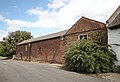
Grade II listed farm buildings in Wirral, England  | |||||
| Upload media | |||||
| Instance of | |||||
|---|---|---|---|---|---|
| Location | Raby, Wirral, Merseyside, North West England, England | ||||
| Heritage designation |
| ||||
 | |||||
Media in category "Barns at Corner Farm, Raby"
The following 3 files are in this category, out of 3 total.
-
 Barns at Corner Farm, Raby 1.jpg 4,618 × 2,831; 16.67 MB
-
 Barns at Corner Farm, Raby 2.jpg 7,507 × 2,425; 15.52 MB
-
 Barns at Corner Farm, Raby 3.jpg 4,981 × 3,422; 19.91 MB

