Category:Barrage de Grandval
Jump to navigation
Jump to search
| Object location | | View all coordinates using: OpenStreetMap |
|---|
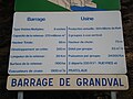
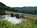
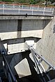
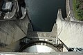
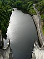
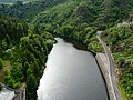
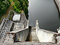
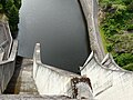
Français : Cette catégorie regroupe les médias concernant le barrage de Grandval, dans le département du Cantal (région Auvergne-Rhône-Alpes), ainsi que son lac de retenue long d'environ 28 kilomètres, dans lequel se jette le Bès. L'ouvrage barre le cours de la Truyère entre les communes de Lavastrie au nord, et Fridefont au sud.
dam in France  | |||||
| Upload media | |||||
| Instance of | |||||
|---|---|---|---|---|---|
| Location | |||||
| Located in or next to body of water | |||||
| Owned by | |||||
| Service entry |
| ||||
| Inception |
| ||||
| Nominal power capacity |
| ||||
| Length |
| ||||
| Drainage basin |
| ||||
| Reservoir created |
| ||||
 | |||||
Subcategories
This category has the following 2 subcategories, out of 2 total.
G
- Grandval substation (2 F)
L
- Lac de Grandval (6 F)
Media in category "Barrage de Grandval"
The following 24 files are in this category, out of 24 total.
-
 Barrage de Grandval 1.JPG 3,072 × 2,304; 2.5 MB
-
 Barrage de Grandval.jpg 4,284 × 2,844; 7.66 MB
-
 Barrage Grandval depuis amont.jpg 3,212 × 2,407; 1.78 MB
-
 Barrage-de-Grandval-dpt-Cantal-DSC2-332.jpg 4,928 × 2,610; 6.83 MB
-
 Barrage-de-Grandval-sur-la-Truyère-dpt-Cantal-DSC2-324.jpg 4,928 × 3,264; 7.72 MB
-
 Barrage-grandval-aval.jpg 4,608 × 3,456; 3.58 MB
-
 Barrage-grandval-retenue.jpg 4,608 × 3,456; 3.56 MB
-
 Barrage-grandval-vanne.jpg 4,608 × 3,456; 3.47 MB
-
 Evacuateur de crue du barrage de Grandval sur la Truyère dpt Cantal DSC2-313.JPG 3,264 × 4,928; 8.79 MB
-
 Evacuateur de crue du barrage de Grandval sur la Truyère dpt Cantal DSC2-319.JPG 3,264 × 4,928; 7.5 MB
-
 Evacuateur de crue du barrage de Grandval sur la Truyère dpt Cantal DSC2-327.JPG 4,928 × 3,264; 6.96 MB
-
 Evacuateur de crue du barrage de Grandval sur la Truyère dpt Cantal DSC2-329.JPG 4,928 × 3,264; 8.02 MB
-
 France ARA 45 Barrage de Grandval 01.jpg 3,008 × 2,000; 2.84 MB
-
 France ARA 45 Barrage de Grandval 02.jpg 3,008 × 2,000; 2.9 MB
-
 France ARA 45 Barrage de Grandval 03.jpg 2,000 × 3,008; 2.58 MB
-
 France ARA 45 Barrage de Grandval 04.jpg 3,008 × 2,000; 3.1 MB
-
 Porte de l'évacuateur de crue du barrage de Grandval sur la Truyère dpt Cantal DSC2-318.JPG 3,264 × 4,928; 6.23 MB
-
 Poste transformation Grandval (1).jpg 2,985 × 2,236; 1.48 MB
-
 Ruiseau d'Arcomie amont pont D13.jpg 3,152 × 2,362; 1.6 MB
-
 Truyère aval barrage Grandval (1).jpg 2,324 × 3,096; 1.81 MB
-
 Truyère aval barrage Grandval.jpg 3,264 × 2,448; 3.78 MB
-
 Truyère aval pont D909.jpg 3,264 × 2,220; 1.45 MB
-
 Évacuateur crues Grandval.jpg 3,130 × 2,351; 2.04 MB
-
 Évacuateurs crues Grandval.jpg 2,958 × 2,221; 1.75 MB


.jpg)


.jpg)