Category:Barrowford
Jump to navigation
Jump to search
English: Barrowford is a large village and civil parish in the Pendle district of Lancashire, England. It is situated to the north of Nelson on the other side of the M65 motorway, and forms part of the Burnley/Nelson conurbation. It also comprises the area of Lowerford and sometimes gets confused with its neighbour Higherford. According to the 2001 census it had a population of 6,039.

village and civil parish in Lancashire, England  | |||||
| Upload media | |||||
| Instance of | |||||
|---|---|---|---|---|---|
| Location | Pendle, Lancashire, North West England, England | ||||
| Said to be the same as | Barrowford (Wikimedia duplicated page, civil parish) | ||||
 | |||||
Subcategories
This category has the following 5 subcategories, out of 5 total.
Media in category "Barrowford"
The following 200 files are in this category, out of 309 total.
(previous page) (next page)-
 "Brook Dell House" Fore Side, Higherford - geograph.org.uk - 2483903.jpg 3,072 × 2,304; 1.38 MB
-
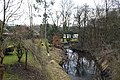
 "Cutaway" at Barrowford (Leeds-Liverpool Canal) - geograph.org.uk - 1832465.jpg 1,630 × 960; 439 KB
-

-
 "Old Bridge Inn" Barrowford - geograph.org.uk - 506512.jpg 612 × 460; 150 KB
-

-
 "The Maltkiln", Gisburn Road, Barrowford - geograph.org.uk - 506500.jpg 460 × 612; 132 KB
-

-
 1a Gisburn Road, Barrowford - geograph.org.uk - 696816.jpg 640 × 480; 82 KB
-
 3, 5 and 7 Fold, Barrowford.jpg 4,008 × 3,006; 3.97 MB
-
 A choice of three - geograph.org.uk - 506489.jpg 480 × 640; 163 KB
-
 A glimpse of Booth's supermarket, Barrowford - geograph.org.uk - 6304291.jpg 4,446 × 3,474; 4.56 MB
-
 A small mill put to a new use - geograph.org.uk - 4962000.jpg 2,341 × 3,273; 4.35 MB
-
 A6068 towards Padiham - geograph.org.uk - 5869145.jpg 640 × 480; 61 KB
-
 A682 at Bank Fold - geograph.org.uk - 4339962.jpg 640 × 480; 59 KB
-
 A682 towards Long Preston - geograph.org.uk - 5870316.jpg 640 × 480; 84 KB
-
 Alley behind May Street, Barrowford - geograph.org.uk - 3177939.jpg 4,320 × 3,240; 3.44 MB
-
 Along the ridge from Noggarth Cottage - geograph.org.uk - 2745321.jpg 3,872 × 2,592; 3.98 MB
-
 Approaching Barnoldswick Road, Higherford - geograph.org.uk - 2439577.jpg 4,268 × 3,237; 2.65 MB
-
 Asinus es. - panoramio.jpg 1,877 × 1,789; 554 KB
-
 At Pendle Heritage Centre - panoramio (1).jpg 1,827 × 1,794; 832 KB
-
 At Pendle Heritage Centre - panoramio.jpg 1,521 × 1,527; 472 KB
-
 B6249 Carr Road, Nelson - geograph.org.uk - 2568499.jpg 3,072 × 2,304; 1.47 MB
-
 Back street off Maud Street, Barrowford - geograph.org.uk - 696864.jpg 480 × 640; 186 KB
-
 Band Stand, Victoria Park, Nelson.jpg 3,000 × 2,000; 5.88 MB
-
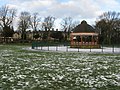 Bandstand, Victoria Park, Nelson - geograph.org.uk - 1139510.jpg 640 × 480; 114 KB
-
 Bandstand, Victoria Park, Nelson, Lancashire - geograph.org.uk - 2568538.jpg 2,814 × 1,350; 846 KB
-
 Bank Fold off Gisburn Road, Barrowford - geograph.org.uk - 2483925.jpg 3,066 × 1,675; 1.04 MB
-
 Barleydale Road, Higherford, Barrowford - geograph.org.uk - 2483889.jpg 3,072 × 2,304; 1.37 MB
-
 Barn, Barleydale Road, Higherford - geograph.org.uk - 2483893.jpg 3,066 × 1,644; 1.45 MB
-
 Barn, Park Hill, Barrowford.jpg 1,632 × 1,224; 480 KB
-
 Barowford 02.jpg 2,560 × 1,920; 2.31 MB
-
 Barowford 03.jpg 2,560 × 1,920; 2.29 MB
-
 Barowford 07.jpg 2,427 × 1,434; 546 KB
-
 Barowford 08.jpg 1,605 × 1,641; 515 KB
-
 Barowford 09.jpg 2,560 × 1,920; 2.53 MB
-
 Barowford 10.jpg 2,560 × 1,920; 2.4 MB
-
 Barowford 11.jpg 1,788 × 1,749; 540 KB
-
 Barowford 12.jpg 2,560 × 1,920; 2.25 MB
-
 Barrowford 01.jpg 2,560 × 1,920; 2.31 MB
-
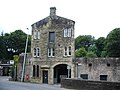
 Barrowford Bar Toll House - geograph.org.uk - 6366150.jpg 2,592 × 1,944; 1.29 MB
-
 Barrowford Bottom Lock No 51 - geograph.org.uk - 5954823.jpg 640 × 507; 81 KB
-
 Barrowford Bridge - geograph.org.uk - 4956546.jpg 640 × 480; 575 KB
-
 Barrowford Bridge and Higherford Mill - geograph.org.uk - 6366157.jpg 2,592 × 1,944; 1.49 MB
-
 Barrowford Bridge, Pendle Water - geograph.org.uk - 4957383.jpg 640 × 481; 649 KB
-
 Barrowford Bridge, Pendle Water, Barrowford, Lancashire - geograph.org.uk - 1832383.jpg 1,632 × 1,224; 545 KB
-
 Barrowford Bridge.jpg 1,632 × 1,224; 493 KB
-
 Barrowford County Primary School - A Great Place to Learn - panoramio.jpg 1,662 × 1,678; 426 KB
-
 Barrowford County Primary School - panoramio.jpg 1,626 × 1,653; 519 KB
-
 Barrowford fb - geograph.org.uk - 5331222.jpg 427 × 640; 77 KB
-
 Barrowford Locks - geograph.org.uk - 4694378.jpg 3,954 × 3,021; 1.7 MB
-
 Barrowford Locks - panoramio (1).jpg 2,072 × 1,905; 528 KB
-
 Barrowford Locks - panoramio (3).jpg 1,847 × 1,825; 613 KB
-
 Barrowford Locks - panoramio (4).jpg 1,682 × 1,709; 441 KB
-
 Barrowford Locks - panoramio (5).jpg 2,070 × 1,917; 754 KB
-
 Barrowford Locks - panoramio (7).jpg 1,838 × 1,703; 646 KB
-

-
 Barrowford Locks, Pendle, Lancashire - geograph.org.uk - 1832437.jpg 1,224 × 1,632; 480 KB
-
 Barrowford Locks, Pendle, Lancashire - geograph.org.uk - 1832440.jpg 1,632 × 1,224; 449 KB
-
 Barrowford Lower Clough Mill - geograph.org.uk - 5461961.jpg 3,456 × 2,304; 3.17 MB
-
 Barrowford Memorial Park, Lancashire - geograph.org.uk - 1832399.jpg 1,632 × 1,224; 504 KB
-

-
 Barrowford Park was awarded the prestigious Green Flag award. - panoramio.jpg 1,530 × 1,494; 459 KB
-
 Barrowford Reservoir - geograph.org.uk - 4175163.jpg 3,264 × 2,448; 2.38 MB
-
 Barrowford Reservoir - geograph.org.uk - 4175169.jpg 3,264 × 2,448; 2.44 MB
-
 Barrowford Reservoir - geograph.org.uk - 5954965.jpg 640 × 421; 59 KB
-

-
 Barrowford Road Bridge 143, Leeds-Liverpool Canal - geograph.org.uk - 1832417.jpg 1,632 × 1,224; 883 KB
-
 Beside Pendle Water - geograph.org.uk - 3177917.jpg 4,320 × 3,240; 3.01 MB
-
 Blacko, A682 - geograph.org.uk - 5904392.jpg 683 × 1,024; 176 KB
-
 Blue-Green Algae - geograph.org.uk - 1594938.jpg 640 × 480; 84 KB
-
 Booths Car Park - geograph.org.uk - 6224337.jpg 1,024 × 768; 496 KB
-
 Booths supermarket car park - geograph.org.uk - 5464072.jpg 2,000 × 1,333; 2.11 MB
-

-
 Bowling ground - panoramio (1).jpg 1,692 × 1,680; 673 KB
-
 Bowling ground - panoramio (2).jpg 1,740 × 1,698; 480 KB
-
 Bridge 142A, Leeds ^ Liverpool Canal - geograph.org.uk - 6075454.jpg 1,280 × 720; 464 KB
-
 Bridge 143, Lock 49 and Bridge 143A - geograph.org.uk - 5434526.jpg 1,024 × 768; 162 KB
-
 Bridge over Pendle Water, B6249 Carr Road, Nelson - geograph.org.uk - 2568513.jpg 3,072 × 2,304; 1.71 MB
-

-

-
 BurnleyBUA2011.png 1,101 × 816; 827 KB
-
 Calder Vale Mill, Chimney - geograph.org.uk - 695478.jpg 480 × 640; 70 KB
-
 Church Street at the A682 junction - geograph.org.uk - 4339945.jpg 640 × 480; 82 KB
-
 Clerk's House, Barrowford - geograph.org.uk - 6304312.jpg 4,934 × 3,730; 4.65 MB
-
 Close up, Elizabeth II postbox on Gisburn Road, Higherford - geograph.org.uk - 5872193.jpg 2,238 × 3,648; 1.54 MB
-
 Colne Road into Barrowford - geograph.org.uk - 4264803.jpg 1,500 × 999; 148 KB
-
 Colne Road, Barrowford - geograph.org.uk - 1832382.jpg 1,630 × 1,028; 445 KB
-
 Colne Road, Barrowford - geograph.org.uk - 1832467.jpg 1,632 × 1,224; 485 KB
-
 Colne, Colne Water - geograph.org.uk - 1759978.jpg 3,456 × 2,304; 5.22 MB
-
 Colne, Wanless Water - geograph.org.uk - 1759354.jpg 3,456 × 2,304; 7.23 MB
-
 Cottage, Fore Side, Higherford (geograph 2483886).jpg 3,072 × 2,304; 1.11 MB
-
 Crown green bowls, Barrowford - geograph.org.uk - 6304298.jpg 5,902 × 3,882; 5.34 MB
-
 Crowtrees Cottage, Barrowford.jpg 3,072 × 2,304; 1.56 MB
-
 Crowtrees, Barrowford (east).jpg 4,008 × 3,005; 4.29 MB
-
 De-watered section of canal south of the M65 - geograph.org.uk - 3251367.jpg 2,048 × 1,536; 744 KB
-
 Deer at Carr Laund - geograph.org.uk - 104359.jpg 640 × 426; 163 KB
-
 East Bank - geograph.org.uk - 2222705.jpg 1,944 × 2,592; 1.14 MB
-
 East Lancs Towel Mill - geograph.org.uk - 3530400.jpg 2,816 × 2,112; 1.16 MB
-
 Elizabeth II postbox on Gisburn Road, Barrowford - geograph.org.uk - 5872160.jpg 1,900 × 3,267; 1.17 MB
-
 Elizabeth II postbox on Gisburn Road, Higherford - geograph.org.uk - 5872191.jpg 3,648 × 2,736; 1.36 MB
-
 Entrance - geograph.org.uk - 1584845.jpg 640 × 480; 109 KB
-
 Farm track off Pasture Lane - geograph.org.uk - 2745903.jpg 3,872 × 2,592; 5.12 MB
-
 Field edge footpath near to Noggarth - geograph.org.uk - 6217219.jpg 4,000 × 3,000; 3.22 MB
-
 Flush Bracket - geograph.org.uk - 5331207.jpg 640 × 453; 112 KB
-
 Footbridge over Pendle Water - geograph.org.uk - 1584839.jpg 640 × 480; 107 KB
-
 Footbridge over Pendle Water - geograph.org.uk - 1584840.jpg 640 × 480; 99 KB
-
 Footbridge over the M65 approaching Colne - geograph.org.uk - 4248179.jpg 1,500 × 964; 103 KB
-
 Footpath from Barleydale Road, Higherford, Barrowford - geograph.org.uk - 2483897.jpg 3,072 × 2,304; 1.65 MB
-
 Footpath off Pasture Lane - geograph.org.uk - 4961889.jpg 4,592 × 3,056; 6.55 MB
-
 Footpath to Barleydale Road - geograph.org.uk - 2483902.jpg 3,072 × 2,304; 1.77 MB
-
 "The George and Dragon" Barrowford - geograph.org.uk - 506604.jpg 640 × 480; 184 KB
-
 Ginnel, Barrowford - geograph.org.uk - 505558.jpg 480 × 640; 193 KB
-
 Gisburn Road (A682), Barrowford - geograph.org.uk - 5869159.jpg 640 × 480; 59 KB
-
 Gisburn Road - geograph.org.uk - 1577462.jpg 640 × 480; 129 KB
-
 Gisburn Road - geograph.org.uk - 4694805.jpg 5,184 × 3,456; 1.79 MB
-

-
 Gisburn Road bridge over Pendle Water - geograph.org.uk - 2483883.jpg 3,072 × 2,304; 1.56 MB
-
 Gisburn Road, Barrowford - geograph.org.uk - 1577436.jpg 640 × 480; 97 KB
-

-
 Grimshaw's (Higherford) Mill - geograph.org.uk - 4957250.jpg 640 × 482; 553 KB
-
 Halstead Lane - geograph.org.uk - 6224336.jpg 1,024 × 768; 593 KB
-
 Height House - geograph.org.uk - 4694814.jpg 5,136 × 2,937; 1.88 MB
-
 Higher Ford Mill and Gisburn Road bridge over Pendle Water - geograph.org.uk - 2483877.jpg 2,304 × 3,072; 1.45 MB
-
 Higher Ridge Farm - geograph.org.uk - 2745906.jpg 3,872 × 2,592; 3.43 MB
-
 Higherford - geograph.org.uk - 4957125.jpg 640 × 480; 590 KB
-
 Higherford Bridge and Mill - geograph.org.uk - 4956971.jpg 640 × 481; 574 KB
-
 Higherford Mill - geograph.org.uk - 2746115.jpg 3,872 × 2,592; 5.11 MB
-
 Higherford Mill - geograph.org.uk - 4957200.jpg 640 × 481; 416 KB
-
 Higherford Mill - geograph.org.uk - 506464.jpg 640 × 480; 231 KB
-
 Higherford Mill - geograph.org.uk - 531056.jpg 640 × 428; 179 KB
-
 Higherford Mill - geograph.org.uk - 531057.jpg 428 × 640; 222 KB
-

-
 Higherford Mill Chimney - geograph.org.uk - 4957245.jpg 480 × 640; 561 KB
-
 Higherford Mill, Barrowford - geograph.org.uk - 506509.jpg 480 × 640; 176 KB
-
 Higherford Old Bridge - geograph.org.uk - 2746106.jpg 3,872 × 2,592; 6.03 MB
-
 Higherford Old Bridge - geograph.org.uk - 4957080.jpg 640 × 481; 569 KB
-
 Higherford Old Bridge - geograph.org.uk - 5809941.jpg 1,024 × 768; 256 KB
-
 Higherford Pack Horse Bridge over Pendle Water, Lancashire - geograph.org.uk - 2483871.jpg 3,072 × 2,304; 1.71 MB
-
 Higherford Pack Horse Bridge over Pendle Water, Lancashire - geograph.org.uk - 2483873.jpg 2,304 × 3,072; 2.35 MB
-
 Higherford Packhorse Bridge - geograph.org.uk - 4957096.jpg 640 × 481; 587 KB
-
 Higherford, Foreside - geograph.org.uk - 4957044.jpg 640 × 481; 473 KB
-
 Higherford, Old Bridge Inn - geograph.org.uk - 4957139.jpg 640 × 480; 433 KB
-
 Hillside above Pendle Water - geograph.org.uk - 2745915.jpg 3,872 × 2,592; 3.59 MB
-
 Hillside down to Pendle Water - geograph.org.uk - 2746095.jpg 3,872 × 2,592; 5.14 MB
-
 Hilltop feeding - geograph.org.uk - 2745354.jpg 3,872 × 2,592; 3.81 MB
-
 House on the banks of Pendle Water - geograph.org.uk - 1832343.jpg 1,632 × 1,224; 927 KB
-
 House, Barleydale Road, Higherford - geograph.org.uk - 2483892.jpg 3,072 × 2,304; 1.57 MB
-
 Houses, Carr Hall Road, Nelson - geograph.org.uk - 2568488.jpg 3,069 × 2,103; 946 KB
-
 Houses, Carr Hall Road-Park Avenue, Nelson - geograph.org.uk - 2568486.jpg 3,069 × 1,914; 1.2 MB
-
 Houses, Park Avenue, Nelson - geograph.org.uk - 2568482.jpg 3,072 × 2,304; 1.44 MB
-
 Houses, Park Avenue-Bedford Street, Nelson - geograph.org.uk - 2568495.jpg 3,072 × 2,304; 1.13 MB
-
 Lamb Working Mens Club, Barrowford.jpg 4,008 × 3,006; 3.76 MB
-
 Lancashire Fingerpost - geograph.org.uk - 5904370.jpg 683 × 1,024; 214 KB
-
 Lancashire Witches Walk - Tercet 1 - geograph.org.uk - 5814692.jpg 1,280 × 1,280; 771 KB
-
 Leeds and Liverpool Canal - geograph.org.uk - 4694375.jpg 5,184 × 3,139; 1.86 MB
-
 Leeds-Liverpool Canal, Barrowford - geograph.org.uk - 1832424.jpg 1,629 × 987; 455 KB
-
 Lock 50, Leeds ^ Liverpool Canal - geograph.org.uk - 6075448.jpg 1,280 × 870; 591 KB
-
 Lock 51 and its bywash, Leeds ^ Liverpool Canal - geograph.org.uk - 5434521.jpg 1,023 × 768; 157 KB
-
 Lock 51, Leeds ^ Liverpool Canal - geograph.org.uk - 6075445.jpg 1,280 × 850; 716 KB
-

-

-
 Lower Clough Mill, Doorway - geograph.org.uk - 695468.jpg 640 × 480; 92 KB
-

-
 M65 eastbound at Lowerford - geograph.org.uk - 3337479.jpg 640 × 480; 51 KB
-

-
 Marles Hill - geograph.org.uk - 4959978.jpg 4,269 × 2,841; 7.34 MB
-
 Narrowboat with garden - panoramio.jpg 1,554 × 1,514; 450 KB
-
 Nelson - geograph.org.uk - 4694804.jpg 5,165 × 3,301; 1.64 MB
-
 Nelson, Regent Street - geograph.org.uk - 1760119.jpg 3,456 × 2,304; 5.77 MB
-

-
 New Footbridge, Victoria Park, Nelson, Lancashire - geograph.org.uk - 2568532.jpg 3,072 × 2,304; 1.41 MB
-
 New road in Riverside Business Park - geograph.org.uk - 1584849.jpg 640 × 480; 44 KB
-
 Noggarth Cottage - geograph.org.uk - 2745316.jpg 3,872 × 2,592; 4.46 MB
-
 Noggarth Cottage. - geograph.org.uk - 4068044.jpg 3,846 × 2,564; 1.92 MB
-
 Nora Street, Barrowford - geograph.org.uk - 2744703.jpg 3,872 × 2,592; 3.29 MB
-
 Notice Board, Barrowford Locks, Pendle, Lancashire - geograph.org.uk - 1832472.jpg 1,632 × 1,224; 539 KB
-
 Now there's a challenge - geograph.org.uk - 2745288.jpg 3,872 × 2,592; 4.82 MB
-
 Old Bridge Inn, Higherford - geograph.org.uk - 4957136.jpg 640 × 481; 452 KB
-
 Old Bridge Inn, Higherford - geograph.org.uk - 5869186.jpg 640 × 492; 67 KB
-
 Old mill on Gisburn Road, Barrowford - geograph.org.uk - 506484.jpg 640 × 480; 162 KB
-
 Old Oak tree Cottage - geograph.org.uk - 4125327.jpg 3,882 × 2,836; 7.81 MB
-
 Ordnance Survey Flush Bracket S8646 - geograph.org.uk - 3205394.jpg 1,280 × 960; 210 KB
-
 Original site of St Thomas, Barrowford - geograph.org.uk - 2796416.jpg 2,350 × 1,763; 1.35 MB
-
 Pair of Barges, Barrowford Locks, Pendle, Lancashire - geograph.org.uk - 1832451.jpg 1,629 × 1,043; 460 KB
-
 Pair of Semis, Barleydale Road, Higherford - geograph.org.uk - 2483894.jpg 3,072 × 2,304; 1.29 MB
-
 Paradise Street off Gisburn Road, Barrowford - geograph.org.uk - 2483920.jpg 3,072 × 2,304; 1.99 MB
-
 Paradise Street, Barrowford - geograph.org.uk - 506539.jpg 640 × 480; 168 KB
-
 Park Hill Farmhouse - geograph.org.uk - 4957369.jpg 640 × 481; 578 KB
-
 Park Hill, Barrowford - geograph.org.uk - 6304274.jpg 5,051 × 3,505; 4.63 MB
-
 Park Street, Barrowford - geograph.org.uk - 2483936.jpg 3,072 × 2,304; 1.37 MB
-
 Pasture by Water Meetings - geograph.org.uk - 3174233.jpg 4,320 × 3,240; 6.13 MB
-
 Pasture House Farm - geograph.org.uk - 980169.jpg 640 × 480; 68 KB
-
 Pasture House Farm near Barrowford (geograph 3236000).jpg 3,648 × 2,736; 951 KB
-
 Pasture House Farm near Barrowford where Elizabeth Shackleton lived (sq cropped).jpg 1,978 × 1,978; 908 KB
-
 Pasture Lane - geograph.org.uk - 4694802.jpg 4,928 × 3,456; 1.79 MB
-
 Pasture Lane - geograph.org.uk - 4961900.jpg 640 × 314; 88 KB
-
 Path down to Barrowford (geograph 2746103).jpg 3,872 × 2,592; 4.73 MB
-
 Path from Higher Ford - geograph.org.uk - 2483912.jpg 3,072 × 2,304; 1.84 MB
-
 Path to Higher Ford - geograph.org.uk - 2483916.jpg 3,072 × 2,304; 1.86 MB
-
 Pendle Heritage Centre - geograph.org.uk - 4869094.jpg 3,072 × 1,728; 1.92 MB

_-_geograph.org.uk_-_1832465.jpg)
_-_geograph.org.uk_-_1832429.jpg)

_Gisburn_Road_Barrowford_Nelson_Lancashire_BB9_6JD_-_geograph.org.uk_-_1832386.jpg)


.jpg)


.jpg)
.jpg)
.jpg)
.jpg)
.jpg)


.jpg)
.jpg)


.jpg)


.jpg)


,_Barrowford_-_geograph.org.uk_-_5869159.jpg)


_Mill_-_geograph.org.uk_-_4957250.jpg)


.jpg)
.jpg)


.jpg)


