Category:Barwood, West Yorkshire
Jump to navigation
Jump to search
Media in category "Barwood, West Yorkshire"
The following 19 files are in this category, out of 19 total.
-
 A curve on the canal, Sowerby Bridge - geograph.org.uk - 5604855.jpg 2,000 × 1,500; 1.44 MB
-
 Benchmark on High Royd Bridge - geograph.org.uk - 6024825.jpg 683 × 1,024; 292 KB
-
 Former engine house, High Royd sewage works - geograph.org.uk - 6065683.jpg 1,024 × 768; 354 KB
-
 Gate on Sowerby Bridge FP35, Luddendenfoot - geograph.org.uk - 5454881.jpg 2,000 × 1,500; 1.38 MB
-
 Gate on Sowerby Bridge FP35, Luddendenfoot - geograph.org.uk - 5454901.jpg 2,000 × 1,500; 1.17 MB
-
 Gate on Sowerby Bridge FP38 at Throstle Nest, Luddendenfoot - geograph.org.uk - 5454758.jpg 2,000 × 1,500; 1.13 MB
-
 Giant swan on the canal bank, Sowerby Bridge - geograph.org.uk - 5590491.jpg 2,000 × 1,500; 1.32 MB
-

-
 Primary treatment tanks, High Royd sewage works - geograph.org.uk - 6065681.jpg 1,024 × 768; 388 KB
-
 Rose Grove Lane at High Royd Bridge junction - geograph.org.uk - 6025840.jpg 683 × 1,024; 183 KB
-
 Sowerby Bridge FP35 and a branch off it - geograph.org.uk - 5454908.jpg 2,000 × 1,500; 1.12 MB
-
 Sowerby Bridge FP35 at Warley Wood Lane, Luddendenfoot - geograph.org.uk - 5454867.jpg 2,000 × 1,500; 1.29 MB
-

-
 Sowerby Bridge FP38 and a seat, Luddendenfoot - geograph.org.uk - 5454785.jpg 2,000 × 1,500; 1.09 MB
-
 Sowerby Bridge FP38 approaching a gate - geograph.org.uk - 5454893.jpg 2,000 × 1,456; 751 KB
-
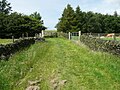 Sowerby Bridge FP38 in a grass lane, Luddendenfoot - geograph.org.uk - 5454764.jpg 2,000 × 1,500; 1.27 MB
-
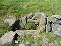 Spring and trough next to Sowerby Bridge FP35, Luddendenfoot - geograph.org.uk - 5454891.jpg 2,000 × 1,500; 1.51 MB
-
 Stile and gate on Sowerby Bridge FP38, Luddendenfoot - geograph.org.uk - 5454780.jpg 2,000 × 1,500; 1.21 MB
-


