Category:Battle, East Sussex
Jump to navigation
Jump to search
town and civil parish in the local government district of Rother in East Sussex, England  | |||||
| Upload media | |||||
| Instance of | |||||
|---|---|---|---|---|---|
| Named after | |||||
| Location | Rother, East Sussex, South East England, England | ||||
| Population |
| ||||
| Area |
| ||||
| Said to be the same as | Battle (Wikimedia duplicated page, civil parish) | ||||
| official website | |||||
 | |||||
Deutsch: Battle ist ein Ort mit rund 6000 Einwohnern in East Sussex, England, ca. 8 km von Hastings entfernt. An dieser Stelle fand im Jahre 1066 die Schlacht bei Hastings statt.
English: Battle is a small town in the local government district of Rother in East Sussex, England. It lies east of the county town of Lewes. Nearby towns include Hastings to the southeast and Bexhill-On-Sea to the south.
Suomi: Battle on pieni kaupunki East Sussexin kreivikunnassa Englannissa. Se sijaitsee noin kahdeksan kilometriä Hastingsistä, jonka lähettyvillä käytiin Hastingsin taistelu vuonna 1066.
Nāhuatl: Battle ( xihuitl.
Nederlands: Battle is een plaats in het district Rother in East Sussex, Engeland. Het ligt 79 kilometer ten zuidzuidoosten van Londen.
Norsk bokmål: Battle er en liten by i East Sussex i England. Den ligger omkring 8 km fra Hastings, og ligger ved stedet hvor slaget ved Hastings stod i 1066. Navnet kommer fra dette slaget (på engelsk «Battle of Hastings»)
Polski: Battle – miasto portowe w Wielkiej Brytanii, w Anglii, w regionie South East England, w hrabstwie East Sussex. W 2001 r. miasto to na powierzchni 31,8 km² zamieszkiwało 6171 osób. W Battle powstała brytyjska formacja muzyczna, grająca rock alternatywny - Keane.
Română: Battle este un oraş în comitatul East Sussex, regiunea South East, Anglia. Oraşul se află în districtul Rother.
Русский: Баттл — небольшой город в графстве Восточный Суссекс, Англия, примерно в 8 км от Гастингса. Население — 6171 человек (на 2007 год). Место битвы при Гастингсе.
Simple English: Battle is a town in East Sussex, England, UK. It is known as this because it was the place where the Battle of Hastings was fought.
Svenska: Battle är en mindre stad i East Sussex i England, ungefär 8 kilometer från Hastings. I närheten skedde slaget vid Hastings, där Vilhelm Erövraren besegrade Harald II år 1066.
Subcategories
This category has the following 9 subcategories, out of 9 total.
Media in category "Battle, East Sussex"
The following 200 files are in this category, out of 1,222 total.
(previous page) (next page)-
 'Farrago', gift shop, Battle - geograph.org.uk - 3793457.jpg 1,600 × 1,388; 461 KB
-
 1066 Battlefield Sculpture Trail - geograph.org.uk - 6271963.jpg 3,264 × 2,448; 3.27 MB
-
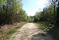
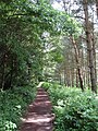 1066 Country Walk - geograph.org.uk - 1355485.jpg 480 × 640; 179 KB
-
 1066 Country Walk - geograph.org.uk - 2050369.jpg 640 × 480; 148 KB
-
 1066 Country Walk - geograph.org.uk - 2186698.jpg 640 × 430; 187 KB
-
 1066 Country Walk - geograph.org.uk - 2489468.jpg 640 × 430; 143 KB
-
 1066 Country Walk - geograph.org.uk - 2491182.jpg 640 × 430; 101 KB
-
 1066 Country Walk - geograph.org.uk - 2491328.jpg 640 × 430; 113 KB
-
 1066 Country Walk - geograph.org.uk - 4043616.jpg 4,000 × 3,000; 4.11 MB
-
 1066 Country Walk - geograph.org.uk - 4353788.jpg 640 × 427; 114 KB
-
 1066 Country Walk along Long Plantation - geograph.org.uk - 2186700.jpg 640 × 430; 173 KB
-

-
 1066 Country Walk at Battle - geograph.org.uk - 4639434.jpg 640 × 480; 94 KB
-
 1066 Country Walk divides - geograph.org.uk - 2186709.jpg 640 × 430; 127 KB
-

-
 1066 Country Walk heads to Catsfield - geograph.org.uk - 4043620.jpg 4,000 × 3,000; 4.23 MB
-
 1066 Country Walk heads west - geograph.org.uk - 2187752.jpg 640 × 430; 148 KB
-
 1066 Country Walk in Great Wood - geograph.org.uk - 2491360.jpg 640 × 430; 145 KB
-
 1066 Country Walk in Great Wood - geograph.org.uk - 3445162.jpg 4,320 × 3,240; 6.17 MB
-
 1066 Country Walk in Hoathybank Wood - geograph.org.uk - 3442976.jpg 4,320 × 3,240; 5.64 MB
-
 1066 Country Walk in Saxon Wood - geograph.org.uk - 3443031.jpg 4,320 × 3,240; 6.18 MB
-
 1066 Country Walk leaves Battle - geograph.org.uk - 2186677.jpg 640 × 430; 160 KB
-
 1066 Country Walk leaving Saxon Wood - geograph.org.uk - 2186837.jpg 640 × 430; 173 KB
-
 1066 Country Walk link path heads south - geograph.org.uk - 2186711.jpg 640 × 430; 150 KB
-
 1066 Country Walk near Farthings Farm - geograph.org.uk - 3442985.jpg 4,320 × 3,240; 4.55 MB
-
 1066 Country Walk near Saxon Wood - geograph.org.uk - 4043625.jpg 4,000 × 3,000; 4.22 MB
-
 1066 Country Walk off Marley Lane - geograph.org.uk - 2489463.jpg 430 × 640; 120 KB
-
 1066 Country Walk on its way to Catsfield - geograph.org.uk - 4043630.jpg 4,000 × 3,000; 4.41 MB
-
 1066 Country Walk rounds Saxon Wood - geograph.org.uk - 2186730.jpg 640 × 430; 140 KB
-
 1066 Country Walk to Catsfield - geograph.org.uk - 2187758.jpg 640 × 430; 189 KB
-
 1066 Country Walk to Pevensey - geograph.org.uk - 2186726.jpg 640 × 430; 105 KB
-
 1066 Country Walk, Great Wood - geograph.org.uk - 2489478.jpg 640 × 430; 84 KB
-
 1066 Country Walk, Great Wood - geograph.org.uk - 2491162.jpg 640 × 430; 120 KB
-
 1066 Country Walk, Great Wood - geograph.org.uk - 2491166.jpg 640 × 430; 115 KB
-
 1066 Country Walk, Great Wood - geograph.org.uk - 2491342.jpg 640 × 430; 108 KB
-
 1066 Country Walk, Great Wood - geograph.org.uk - 2491366.jpg 640 × 430; 145 KB
-
 1066 Country Walk, Powdermills Wood - geograph.org.uk - 2187766.jpg 640 × 430; 205 KB
-
 1066 Country Walk, Saxon Wood - geograph.org.uk - 2186822.jpg 640 × 430; 208 KB
-
 1066 Country Walk, Saxon Wood - geograph.org.uk - 2186825.jpg 640 × 430; 208 KB
-
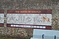 1066 mural, Battle Station - geograph.org.uk - 5808575.jpg 1,024 × 681; 178 KB
-
 1066 sculpture - geograph.org.uk - 5217465.jpg 4,000 × 3,000; 3.91 MB
-
 1066 sculpture - geograph.org.uk - 5217466.jpg 4,000 × 3,000; 3.5 MB
-
 1066 Walk waymark, Marley Rd - geograph.org.uk - 1721060.jpg 640 × 507; 116 KB
-
 13 - 16, Lower Lake - geograph.org.uk - 3419250.jpg 640 × 430; 68 KB
-
 17-20 Mount Street - geograph.org.uk - 3917118.jpg 640 × 480; 80 KB
-
 5 ^ 7, Virgin's Lane - geograph.org.uk - 4414202.jpg 1,440 × 1,080; 523 KB
-
 6, 8, 10, Upper Lake - geograph.org.uk - 3419306.jpg 640 × 430; 64 KB
-
 9, Mount Street - geograph.org.uk - 3917124.jpg 640 × 480; 70 KB
-
 A carved horse - geograph.org.uk - 5218944.jpg 800 × 600; 125 KB
-
 A carved soldier - geograph.org.uk - 5218942.jpg 1,024 × 768; 234 KB
-
 A carved soldier and horse - geograph.org.uk - 5218943.jpg 600 × 800; 137 KB
-
 A cat with stile^ - geograph.org.uk - 558670.jpg 480 × 640; 154 KB
-
 A cow grazing, George Meadow - geograph.org.uk - 2186690.jpg 640 × 430; 116 KB
-
 A Junction of Rides in Great Wood - geograph.org.uk - 3445176.jpg 4,320 × 3,240; 7.55 MB
-

-
 A tributary of the River Line - geograph.org.uk - 3424714.jpg 640 × 430; 117 KB
-
 A wealden iron stream - geograph.org.uk - 402881.jpg 428 × 640; 501 KB
-

-
 A2100 Hastings Road, Telham - geograph.org.uk - 6137931.jpg 1,024 × 684; 258 KB
-
 A2100 Hastings Road, Telham - geograph.org.uk - 6137934.jpg 1,024 × 684; 265 KB
-
 A2100 in Battle (1880).jpg 4,288 × 2,848; 6.75 MB
-
 A2100 London Road - geograph.org.uk - 6137102.jpg 1,024 × 684; 317 KB
-
 A2100 London Road - geograph.org.uk - 6137107.jpg 1,024 × 684; 321 KB
-
 A2100 London Road - geograph.org.uk - 6137116.jpg 1,024 × 684; 364 KB
-
 A2100 near Battle - geograph.org.uk - 3454587.jpg 1,600 × 1,061; 511 KB
-
 A2100 towards Battle - geograph.org.uk - 2001668.jpg 1,024 × 679; 259 KB
-
 A2100 towards Battle - geograph.org.uk - 2001671.jpg 1,024 × 679; 241 KB
-
 A2100, B2095 junction - geograph.org.uk - 3419237.jpg 640 × 430; 104 KB
-
 A2100, Battle - geograph.org.uk - 2186363.jpg 640 × 430; 119 KB
-
 A271 - geograph.org.uk - 3423425.jpg 640 × 430; 85 KB
-
 Abbey Auction Gallery - geograph.org.uk - 2186369.jpg 640 × 430; 123 KB
-
 Abbey Auction Gallery - geograph.org.uk - 3419246.jpg 640 × 430; 75 KB
-
 Abbey Court - geograph.org.uk - 2375705.jpg 640 × 481; 116 KB
-
 Abbey Court off Battle High Street - geograph.org.uk - 5533505.jpg 1,790 × 1,211; 723 KB
-
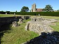 Abbey Crypt, Battle Abbey - geograph.org.uk - 5219689.jpg 1,024 × 768; 257 KB
-
 Abbey Green Cottage - geograph.org.uk - 2186406.jpg 640 × 430; 128 KB
-
 Abbey Green, Battle - geograph.org.uk - 2186417.jpg 640 × 430; 127 KB
-
 Abbey Green, Battle - geograph.org.uk - 4639248.jpg 640 × 480; 76 KB
-
 Abbey Green, Battle - geograph.org.uk - 5925704.jpg 1,024 × 768; 237 KB
-
 Abbey Hotel inn sign - geograph.org.uk - 3881180.jpg 480 × 640; 175 KB
-
 Abbey View - geograph.org.uk - 2727629.jpg 800 × 600; 113 KB
-
 Abbot's Cottage - geograph.org.uk - 3419314.jpg 640 × 430; 71 KB
-
 Access road from Millers Farm - geograph.org.uk - 4043337.jpg 4,000 × 3,000; 3.93 MB
-
 Access road from Peppering Eye Farm - geograph.org.uk - 4043092.jpg 4,000 × 3,000; 4.36 MB
-
 Access road in Powdermills Wood - geograph.org.uk - 4096975.jpg 4,896 × 3,672; 5.61 MB
-
 Access road to Millers Farm - geograph.org.uk - 4043328.jpg 4,000 × 3,000; 3.95 MB
-
 Acorn Farm - geograph.org.uk - 3446760.jpg 640 × 430; 64 KB
-
 Adams Farm, Sandrock Hill, Battle (2).jpg 4,608 × 3,456; 3.42 MB
-
 Adams Farm, Sandrock Hill, Battle.jpg 4,608 × 2,592; 1.11 MB
-
 Adder's tongue fern - geograph.org.uk - 5443859.jpg 640 × 480; 89 KB
-
 Allotments, Caldbec Hill - geograph.org.uk - 1721180.jpg 640 × 430; 129 KB
-

-
 Anglo-Saxons, 1066 re-enactment, Battle - geograph.org.uk - 2472105.jpg 1,600 × 1,200; 649 KB
-
 Anglo-Saxons, Battle Abbey - geograph.org.uk - 2472110.jpg 1,600 × 1,200; 821 KB
-
 Approaching Battle - geograph.org.uk - 3462832.jpg 3,776 × 2,520; 4.17 MB
-

-
 Arch over Rue de Bayeux - geograph.org.uk - 5275406.jpg 4,226 × 2,425; 2.25 MB
-
 Arched entrance - geograph.org.uk - 5218973.jpg 600 × 800; 134 KB
-
 Ashes Wood - geograph.org.uk - 2650597.jpg 640 × 480; 157 KB
-
 Ashes Wood - geograph.org.uk - 2650599.jpg 640 × 480; 174 KB
-
 Ashes Wood - geograph.org.uk - 3431947.jpg 640 × 430; 123 KB
-
 Ashes Wood - geograph.org.uk - 3431953.jpg 640 × 430; 121 KB
-
 Ashes Wood - geograph.org.uk - 3431983.jpg 640 × 430; 114 KB
-
 Ashes Wood - geograph.org.uk - 3432007.jpg 640 × 430; 77 KB
-
 Ashlyn, Whatlington Road opposite Virgin's Lane, Battle - geograph.org.uk - 5542700.jpg 2,778 × 2,070; 1.35 MB
-
 Asten Fields at the junction of North Trade Road - geograph.org.uk - 3113465.jpg 2,048 × 1,536; 1.39 MB
-
 Asten Fields, Battle - geograph.org.uk - 2986065.jpg 4,320 × 3,240; 3.73 MB
-
 Asten Fields, Battle - geograph.org.uk - 2986073.jpg 4,320 × 3,240; 3.73 MB
-
 Asten Fields, Battle - geograph.org.uk - 2986076.jpg 4,320 × 3,240; 3.94 MB
-
 Asten Fields, Battle - geograph.org.uk - 2986107.jpg 4,320 × 3,240; 4.07 MB
-
 Autumn colours, 1066 Country Walk - geograph.org.uk - 2187761.jpg 640 × 430; 185 KB
-
 Autumnal colours, 1066 Country Walk - geograph.org.uk - 2186801.jpg 640 × 430; 152 KB
-
 B2096 at edge of Beechdown Wood - geograph.org.uk - 2001676.jpg 1,024 × 679; 246 KB
-
 B2096 Battle Road - geograph.org.uk - 2652110.jpg 640 × 480; 75 KB
-
 B2096 through Darwell Hole - geograph.org.uk - 4893986.jpg 480 × 640; 113 KB
-
 B2096 to Netherfield - geograph.org.uk - 4893995.jpg 640 × 480; 79 KB
-
 B2096 towards Netherfield - geograph.org.uk - 6137954.jpg 1,024 × 684; 342 KB
-
 B2096, Netherfield - geograph.org.uk - 4771770.jpg 640 × 428; 100 KB
-
 Bailiff's Cottage - geograph.org.uk - 3424726.jpg 640 × 430; 88 KB
-
 Bales, Netherfield Place Farm - geograph.org.uk - 3432092.jpg 640 × 430; 63 KB
-
 Bandstand, Market Square - geograph.org.uk - 3464790.jpg 2,095 × 1,415; 1,002 KB
-
 Barn at Peppering Eye Farm - geograph.org.uk - 2375756.jpg 640 × 480; 96 KB
-
 Barn Field - geograph.org.uk - 6244300.jpg 640 × 480; 72 KB
-
 Barn, Beardell Farm - geograph.org.uk - 344649.jpg 640 × 479; 153 KB
-
 Barn, Beech Farm - geograph.org.uk - 3424730.jpg 640 × 430; 52 KB
-
 Barn, Upper Homestead Farm - geograph.org.uk - 3446776.jpg 640 × 430; 44 KB
-
 Barns, Little Park Farm - geograph.org.uk - 1721144.jpg 640 × 430; 131 KB
-
 Battle - East Sussex dot.png 417 × 599; 122 KB
-
 Battle - town centre - geograph.org.uk - 2050374.jpg 640 × 480; 136 KB
-
 Battle abbey - geograph.org.uk - 4172766.jpg 640 × 427; 64 KB
-
 Battle Abbey - geograph.org.uk - 4703293.jpg 4,896 × 3,672; 5.12 MB
-
 Battle Abbey - geograph.org.uk - 6188948.jpg 3,286 × 4,929; 1.41 MB
-
 Battle Abbey - geograph.org.uk - 6189173.jpg 3,456 × 5,184; 1.57 MB
-
 Battle Abbey - geograph.org.uk - 6435446.jpg 1,201 × 1,801; 602 KB
-
 Battle Abbey Dormitory - geograph.org.uk - 5219707.jpg 800 × 600; 136 KB
-
 Battle Abbey east range - geograph.org.uk - 4618312.jpg 4,000 × 3,000; 2.25 MB
-
 Battle Abbey from battlefield site - geograph.org.uk - 6435449.jpg 1,800 × 1,200; 466 KB
-
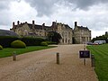
 Battle Abbey Gatehouse - geograph.org.uk - 6203788.jpg 7,016 × 4,677; 7.29 MB
-
 Battle Abbey Gatehouse - geograph.org.uk - 6203792.jpg 6,858 × 4,572; 7.45 MB
-
 Battle Abbey Gatehouse - geograph.org.uk - 6203814.jpg 5,126 × 3,417; 5.09 MB
-
 Battle Abbey Gatehouse - geograph.org.uk - 6203823.jpg 5,879 × 3,919; 6.42 MB
-
 Battle Abbey Gatehouse from the car park - geograph.org.uk - 6203094.jpg 6,062 × 4,041; 5.98 MB
-
 Battle Abbey Phone Box - geograph.org.uk - 2560097.jpg 1,200 × 1,600; 642 KB
-
 Battle Abbey ruin - geograph.org.uk - 4639328.jpg 640 × 480; 94 KB
-
 Battle Abbey ruin - geograph.org.uk - 4639335.jpg 640 × 480; 80 KB
-
 Battle Abbey ruin - geograph.org.uk - 4639387.jpg 640 × 480; 114 KB
-
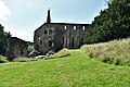
 Battle Abbey School (part of) - geograph.org.uk - 2186672.jpg 640 × 430; 135 KB
-
 Battle Abbey School - geograph.org.uk - 4702146.jpg 4,896 × 3,672; 5.73 MB
-
 Battle Abbey School - geograph.org.uk - 4703306.jpg 4,896 × 3,672; 6.46 MB
-
 Battle Abbey School - geograph.org.uk - 5220416.jpg 1,024 × 680; 265 KB
-
 Battle Abbey School - geograph.org.uk - 5220418.jpg 800 × 531; 136 KB
-
 Battle Abbey School - geograph.org.uk - 5801683.jpg 2,784 × 1,568; 2.04 MB
-
 Battle Abbey School - geograph.org.uk - 6057767.jpg 5,184 × 3,456; 1.38 MB
-
 Battle Abbey School - geograph.org.uk - 6188947.jpg 5,184 × 3,456; 1.71 MB
-

-
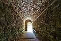
 Battle Abbey vaulted room below the dormitory - geograph.org.uk - 4618279.jpg 4,000 × 3,000; 2.67 MB
-
 Battle Abbey vaults - geograph.org.uk - 6057763.jpg 4,884 × 3,256; 1.37 MB
-
 Battle Abbey west range now Battle Abbey School - geograph.org.uk - 4618385.jpg 4,000 × 3,000; 2.84 MB
-
 Battle Abbey, English Heritage tearoom - geograph.org.uk - 6203811.jpg 6,642 × 4,428; 4.32 MB
-
 Battle Abbey, English Heritage tearoom, outdoor seating area - geograph.org.uk - 6203808.jpg 5,935 × 3,956; 5.16 MB
-
-

-
 Battle Abbey, Southern aspect - geograph.org.uk - 6203895.jpg 6,777 × 4,518; 6.8 MB
-
 Battle Abbey, The Dairy - geograph.org.uk - 6203880.jpg 5,887 × 3,925; 7.17 MB
-
 Battle Abbey, The dormitory - geograph.org.uk - 6203915.jpg 6,329 × 4,219; 6.7 MB
-
 Battle Abbey, The dormitory - geograph.org.uk - 6203917.jpg 5,615 × 3,744; 5.05 MB
-
 Battle Abbey, The dormitory - geograph.org.uk - 6203920.jpg 7,191 × 4,794; 7.42 MB
-
 Battle Abbey, The dormitory, weathered exposed stone work - geograph.org.uk - 6203924.jpg 6,417 × 4,277; 7.41 MB
-
 Battle Abbey, The Duchess of Cleveland's Walled Garden 1 - geograph.org.uk - 6203873.jpg 6,241 × 4,159; 6.36 MB
-
 Battle Abbey, The Duchess of Cleveland's Walled Garden 2 - geograph.org.uk - 6203874.jpg 5,754 × 3,837; 7.8 MB
-
 Battle Abbey, The Duchess of Cleveland's Walled Garden 3 - geograph.org.uk - 6203875.jpg 5,535 × 3,690; 6.63 MB
-
 Battle Abbey, The East Range - geograph.org.uk - 6203882.jpg 6,419 × 4,279; 6.92 MB
-
 Battle Abbey, The Novice's Room - geograph.org.uk - 6203898.jpg 7,140 × 4,760; 6.85 MB
-
 Battle Abbey, The Novice's Room vaulting - geograph.org.uk - 6203902.jpg 6,865 × 4,577; 7.06 MB
-
 Battle Abbey, The Reredorter - geograph.org.uk - 6203886.jpg 6,174 × 4,116; 7.01 MB
-
 Battle Banner.jpg 2,100 × 300; 629 KB
-
 Battle Christmas Tree - geograph.org.uk - 2727613.jpg 800 × 600; 128 KB
-
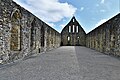
 Battle Church - geograph.org.uk - 3770162.jpg 2,712 × 1,835; 3.08 MB
-
 Battle church - geograph.org.uk - 4384647.jpg 800 × 531; 111 KB
-
 Battle church - geograph.org.uk - 4384648.jpg 531 × 800; 128 KB
-
 Battle church - geograph.org.uk - 5220426.jpg 680 × 1,024; 237 KB
-
 Battle church from Battle Abbey grounds - geograph.org.uk - 5296891.jpg 1,745 × 1,757; 1.11 MB
-
 Battle Community Fire Station - geograph.org.uk - 6262823.jpg 1,280 × 1,041; 1.18 MB
-
 Battle Creek Waste Water Treatment Plant - geograph.org.uk - 4697507.jpg 4,000 × 3,000; 4.05 MB
-
 Battle Creek Waste Water Treatment Plant - geograph.org.uk - 4697509.jpg 3,852 × 2,889; 2.81 MB
-
 Battle Cricket Ground - geograph.org.uk - 2865693.jpg 1,600 × 1,200; 432 KB
-
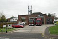 Battle fire station - geograph.org.uk - 1631966.jpg 640 × 427; 209 KB
-
 Battle Fire Station - geograph.org.uk - 3423414.jpg 640 × 430; 52 KB
-
 Battle fish ^ chip shop - geograph.org.uk - 5273120.jpg 3,363 × 2,524; 3.48 MB
-
 Battle Golf Course - geograph.org.uk - 167054.jpg 640 × 480; 121 KB
-
 Battle Golf Course through the trees - geograph.org.uk - 167051.jpg 640 × 480; 124 KB
-
 Battle Health Centre in Station Approach, Battle - geograph.org.uk - 5545005.jpg 2,816 × 2,112; 1.42 MB
-
 Battle High St - geograph.org.uk - 4359217.jpg 640 × 428; 62 KB
-
 Battle High Street - geograph.org.uk - 4633930.jpg 640 × 480; 92 KB
-
 Battle High Street - geograph.org.uk - 4633954.jpg 640 × 480; 84 KB
-
 Battle High Street - geograph.org.uk - 5192154.jpg 2,209 × 941; 591 KB
-
 Battle High Street - geograph.org.uk - 6057769.jpg 5,184 × 3,456; 1.61 MB
-
 Battle High Street - geograph.org.uk - 6057771.jpg 5,184 × 3,456; 1.46 MB
-
 Battle High Street - geograph.org.uk - 6203797.jpg 6,388 × 4,258; 5.61 MB
-
 Battle High Street - geograph.org.uk - 6203802.jpg 6,957 × 4,639; 5.68 MB


.jpg)


.jpg)


_-_geograph.org.uk_-_2186672.jpg)


