Category:Bauernhaus (Bühlikofen 15, Zollikofen)
Jump to navigation
Jump to search
| Object location | | View all coordinates using: OpenStreetMap |
|---|
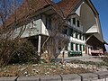
farmhouse in Bühlikofen in the canton of Bern, Switzerland  | |||||
| Upload media | |||||
| Instance of | |||||
|---|---|---|---|---|---|
| Part of | |||||
| Location | Bühlikofen, Zollikofen, Bern-Mittelland administrative district, Bernese Mittelland administrative region, Bern, Switzerland | ||||
| Street address |
| ||||
| Heritage designation |
| ||||
| Inception |
| ||||
 | |||||
Media in category "Bauernhaus (Bühlikofen 15, Zollikofen)"
The following 2 files are in this category, out of 2 total.
-
 Bauernhaus Bühlikofen 15 Zollikofen.jpg 1,778 × 1,185; 2.76 MB
-
 Bühlikofen Bauernhaus.jpg 4,320 × 3,240; 2.66 MB
