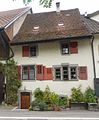
Category:Bauernhaus (Strehlgasse 12, Gelterkinden)
Jump to navigation
Jump to search
| Object location | | View all coordinates using: OpenStreetMap |
|---|
rural alley building in Gelterkinden in the canton of Basel-Landschaft, Switzerland  | |||||
| Upload media | |||||
| Instance of | |||||
|---|---|---|---|---|---|
| Part of | |||||
| Location | Gelterkinden, Sissach District, Basel-Landschaft, Switzerland | ||||
| Street address |
| ||||
| Heritage designation | |||||
 | |||||
Media in category "Bauernhaus (Strehlgasse 12, Gelterkinden)"
This category contains only the following file.
-
 Bauernhaus Strehlgasse 12 , Gelterkinden, CHE.jpg 1,492 × 1,804; 2.05 MB