Category:Beara Way
Jump to navigation
Jump to search
long-distance trail in Republic of Ireland  | |||||
| Upload media | |||||
| Instance of |
| ||||
|---|---|---|---|---|---|
| Location |
| ||||
| Terminus | |||||
| official website | |||||
| |||||
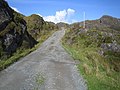
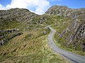
English: The Beara Way is a long-distance trail in Ireland. It is a 206-kilometre (128-mile) long circular trail around the Beara Peninsula that begins and ends in Glengarriff, County Cork. It is designated as a National Waymarked Trail.
Media in category "Beara Way"
The following 20 files are in this category, out of 20 total.
-
 Beara Way - geograph.org.uk - 263659.jpg 640 × 480; 99 KB
-
 Beara Way - geograph.org.uk - 263663.jpg 640 × 480; 119 KB
-
 Beara Way waymark - geograph.org.uk - 263740.jpg 640 × 480; 108 KB
-
 Bofickil, Beara Way - geograph.org.uk - 267048.jpg 480 × 640; 113 KB
-
 Bridge over the Ameen River - geograph.org.uk - 458955.jpg 640 × 427; 151 KB
-
 Cashelkeelty - geograph.org.uk - 268457.jpg 640 × 480; 140 KB
-

-
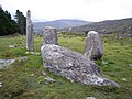 Cashelkeelty Stone Circles - geograph.org.uk - 268467.jpg 640 × 480; 107 KB
-
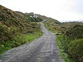
 Dha Dhrom (Ardgroom) - geograph.org.uk - 267952.jpg 640 × 480; 104 KB
-
 Drombohilly Upper - geograph.org.uk - 263222.jpg 640 × 480; 130 KB
-

-
 Garinish Point - geograph.org.uk - 268332.jpg 640 × 480; 100 KB
-
 Gortgarriff - geograph.org.uk - 268104.jpg 640 × 480; 117 KB
-
 Kilcatherine, Beara Way Cycle Route - geograph.org.uk - 268074.jpg 640 × 480; 105 KB
-
 Kilcatherine, Beara Way Cycle Route - geograph.org.uk - 268078.jpg 640 × 480; 97 KB
-
 Kilcatherine, Beara Way Cycle Route - geograph.org.uk - 268080.jpg 640 × 480; 112 KB
-
 Lough Fadda - geograph.org.uk - 268102.jpg 640 × 480; 106 KB
-
 Sign-1100430, Ballyvourney, Co. Cork, Ireland.jpg 4,896 × 3,672; 1.95 MB
-
 View towards Lough Inchiquin - geograph.org.uk - 458961.jpg 640 × 395; 102 KB
-
 View towards Uragh Wood - geograph.org.uk - 458960.jpg 640 × 412; 108 KB


_-_geograph.org.uk_-_267952.jpg)


