Category:Beaufort County, South Carolina
Jump to navigation
Jump to search
Counties of South Carolina: Abbeville · Aiken · Allendale · Anderson · Bamberg · Barnwell · Beaufort · Berkeley · Calhoun · Charleston · Cherokee · Chester · Chesterfield · Clarendon · Colleton · Darlington · Dillon · Dorchester · Edgefield · Fairfield · Florence · Georgetown · Greenville · Greenwood · Hampton · Horry · Jasper · Kershaw · Lancaster · Laurens · Lee · Lexington · Marion · Marlboro · McCormick · Newberry · Oconee · Orangeburg · Pickens · Richland · Saluda · Spartanburg · Sumter · Union · Williamsburg · York
county in South Carolina, United States   | |||||
| Upload media | |||||
| Instance of | |||||
|---|---|---|---|---|---|
| Named after | |||||
| Location | South Carolina | ||||
| Capital | |||||
| Inception |
| ||||
| Population |
| ||||
| Area |
| ||||
| Different from | |||||
| official website | |||||
 | |||||
Subcategories
This category has the following 36 subcategories, out of 36 total.
*
B
C
- Callawassie Island (7 F)
D
- Daufuskie Island (21 F)
E
F
- Fripp Island (7 F)
H
- Haig Point range lights (5 F)
- Haig Point Tabby Ruins (HABS) (27 F)
L
M
- Mitchelville, South Carolina (6 F)
P
R
S
- Saint Helena Sound (1 F)
- Seabrook, South Carolina (71 F)
Y
Media in category "Beaufort County, South Carolina"
The following 19 files are in this category, out of 19 total.
-
 "Refugee quarters" built in Mitchelville.jpg 1,740 × 845; 815 KB
-
 160218-M-RT059-230.jpg 5,760 × 3,840; 1.46 MB
-
 Beaufort County, SC, USA - panoramio.jpg 2,928 × 2,342; 576 KB
-
 Beaufort Harbor 1 - panoramio.jpg 1,500 × 1,200; 641 KB
-
 Beaufort Harbor 2 - panoramio.jpg 1,734 × 1,200; 556 KB
-
 Dell Webb Sun City Hilton Head.jpg 3,148 × 2,350; 1.8 MB
-
 Fripp Island Bridge.JPG 2,592 × 1,944; 1.02 MB
-
 Grave near Old Sheldon Church Ruins - panoramio.jpg 1,965 × 1,300; 604 KB
-
 Harbour Town Golf Links (Unsplash).jpg 4,384 × 3,288; 16.75 MB
-
 L.O. - Vista da sacada do AP - Hilton Head -SC - panoramio.jpg 1,280 × 960; 315 KB
-
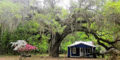 Live Oak on Daufuskie.gif 635 × 315; 177 KB
-
 Map of South Carolina highlighting Beaufort County.svg 4,419 × 3,522; 103 KB
-
 Mitchelville, the new south village for contrabands, Hilton LCCN2014647460 (cropped).jpg 4,643 × 1,779; 2.42 MB
-
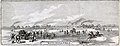
 Mville 1864map.jpg 800 × 510; 168 KB
-

-
 SC St Phillips Island.JPG 447 × 296; 32 KB
-
 Sunset in Bluffton, SC - panoramio.jpg 1,625 × 1,300; 1.29 MB
-
 The Bay (43329238).jpeg 2,048 × 1,356; 650 KB
-
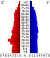 USA Beaufort County, South Carolina age pyramid.svg 520 × 600; 8 KB


.jpg)


.jpeg)

.jpg)