Category:Berriew
Jump to navigation
Jump to search
village and community in Powys, Wales   | |||||
| Upload media | |||||
| Instance of | |||||
|---|---|---|---|---|---|
| Location | Powys, Wales | ||||
| Heritage designation |
| ||||
| Population |
| ||||
| Area |
| ||||
| Different from | |||||
 | |||||
Cymraeg: Pentref a chymuned ym Mhowys, yw Aberriw (Saesneg: Berriew). Saif i'r de-orllewin o'r Trallwng ac i'r gogledd-orllewin o Drefaldwyn. Roedd y boblogaeth yn 2001 yn 1,306.
English: The village has won several 'Best Kept Village' awards - although the scheme has now been discontinued.
Subcategories
This category has the following 4 subcategories, out of 4 total.
Media in category "Berriew"
The following 200 files are in this category, out of 574 total.
(previous page) (next page)-
 "Bird hide", Glansevern Estate - geograph.org.uk - 2605472.jpg 640 × 480; 137 KB
-
 "Stick your pylons" - geograph.org.uk - 2383361.jpg 640 × 480; 224 KB
-
 'Unsuitable for motors' track in the Rhiw Valley - geograph.org.uk - 3344927.jpg 4,000 × 3,000; 3.41 MB
-
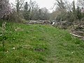
 A Fern lined track to Lower House - geograph.org.uk - 3158736.jpg 640 × 405; 108 KB
-
 A pause in the canal - geograph.org.uk - 632597.jpg 640 × 480; 121 KB
-
 A pause in the canal - geograph.org.uk - 632601.jpg 640 × 480; 94 KB
-

-
 A483 at Fron - geograph.org.uk - 5489350.jpg 640 × 480; 362 KB
-
 A483 at Garthmyl - geograph.org.uk - 3288309.jpg 640 × 480; 57 KB
-
 A483 at Lower Luggy - geograph.org.uk - 3289460.jpg 640 × 480; 40 KB
-
 A483 at Refail - geograph.org.uk - 3288312.jpg 640 × 481; 47 KB
-
 A483 Layby north of Berriew - geograph.org.uk - 5491733.jpg 640 × 480; 380 KB
-
 A483 looking east - geograph.org.uk - 3288308.jpg 640 × 480; 39 KB
-
 A483 near Plas Meredydd - geograph.org.uk - 3288306.jpg 640 × 481; 62 KB
-
 A483 near to Berriew - geograph.org.uk - 5491726.jpg 640 × 427; 330 KB
-
 A483 near to Fron - geograph.org.uk - 5489609.jpg 640 × 480; 366 KB
-
 A483 south approaching Tan-y-Fron - geograph.org.uk - 2961554.jpg 640 × 530; 88 KB
-
 A483 south at Abernant - geograph.org.uk - 2961557.jpg 640 × 436; 103 KB
-

-
 A483 south of Garthmyl, - geograph.org.uk - 5489627.jpg 640 × 480; 410 KB
-
 A483 south passed The Bungalow - geograph.org.uk - 2961546.jpg 640 × 420; 69 KB
-
 Aberriw 462587.jpg 640 × 480; 94 KB
-
 Above Berriew Lock, Montgomery Canal - geograph.org.uk - 4320862.jpg 800 × 534; 129 KB
-
 Approaching Felindre junction - geograph.org.uk - 3579188.jpg 640 × 506; 80 KB
-
 Approaching Pen-y-coppy Farm - geograph.org.uk - 3579068.jpg 640 × 519; 100 KB
-

-

-

-
 B4390 at Pant-y-Ffridd - geograph.org.uk - 2437155.jpg 640 × 480; 83 KB
-
 B4390 at Rhiewport - geograph.org.uk - 3579195.jpg 640 × 466; 105 KB
-
 B4390 into Berriew - geograph.org.uk - 1565148.jpg 640 × 480; 68 KB
-

-
 Barns at Felindre Farm - geograph.org.uk - 6701250.jpg 5,184 × 3,888; 4.94 MB
-
 Belan - geograph.org.uk - 587216.jpg 640 × 480; 68 KB
-

-
 Bend in the road near Gwernydd - geograph.org.uk - 3158710.jpg 640 × 425; 84 KB
-
 Berriew aqueduct - geograph.org.uk - 3344797.jpg 4,000 × 3,000; 3.92 MB
-
 Berriew Aqueduct - geograph.org.uk - 4320951.jpg 800 × 534; 185 KB
-
 Berriew Aqueduct - geograph.org.uk - 6089.jpg 640 × 480; 83 KB
-
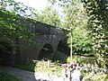 Berriew Aqueduct - Montgomery Canal - geograph.org.uk - 1343052.jpg 640 × 480; 74 KB
-
 Berriew Aqueduct, Powys - geograph.org.uk - 98385.jpg 640 × 479; 101 KB
-
 Berriew Bridge - geograph.org.uk - 1243806.jpg 640 × 480; 103 KB
-
 Berriew Bridge - geograph.org.uk - 5872508.jpg 1,600 × 1,200; 854 KB
-
 Berriew FC (8580570817).jpg 3,339 × 1,470; 2.8 MB
-
 Berriew FC (8581673378).jpg 3,648 × 2,139; 1.37 MB
-
 Berriew FC (8581680042).jpg 3,648 × 2,398; 1.81 MB
-
 Berriew FC (8581680816).jpg 3,247 × 1,759; 1.33 MB
-
 Berriew Lock, Montgomery Canal - geograph.org.uk - 3344821.jpg 4,000 × 3,000; 2.47 MB
-
 Berriew Lock, Montgomery Canal - geograph.org.uk - 3344827.jpg 4,000 × 3,000; 3.26 MB
-
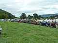
 Berriew Show - a bid for freedom - geograph.org.uk - 3643129.jpg 640 × 480; 152 KB
-
 Berriew Show - a motto for geographers - geograph.org.uk - 3643631.jpg 480 × 640; 146 KB
-

-
 Berriew Show - Balwen Welsh Mountain ram - geograph.org.uk - 3643159.jpg 640 × 480; 157 KB
-
 Berriew Show - Bluefaced Leicester - geograph.org.uk - 3643166.jpg 640 × 480; 173 KB
-

-
-
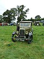
 Berriew Show - elderly tractors - geograph.org.uk - 3643678.jpg 640 × 480; 135 KB
-
 Berriew Show - elderly tractors - geograph.org.uk - 3643682.jpg 640 × 480; 161 KB
-
 Berriew Show - elderly tractors - geograph.org.uk - 3643698.jpg 640 × 480; 126 KB
-
 Berriew Show - Kerry Hill sheep - geograph.org.uk - 3643123.jpg 640 × 480; 174 KB
-
 Berriew Show - pony fancy dress - geograph.org.uk - 3643191.jpg 640 × 480; 145 KB
-
 Berriew Show - Sheep and ponies - geograph.org.uk - 3643134.jpg 640 × 480; 160 KB
-
 Berriew Show - show jumping - geograph.org.uk - 3643086.jpg 640 × 480; 131 KB
-
 Berriew Show - Sleepy Suffolk ram - geograph.org.uk - 3643114.jpg 640 × 480; 148 KB
-
 Berriew Show - something for everyone - geograph.org.uk - 3643623.jpg 640 × 480; 145 KB
-
 Berriew Show - Speckled face sheep - geograph.org.uk - 3643126.jpg 640 × 480; 178 KB
-

-
 Berriew Show - Texels and Suffolks - geograph.org.uk - 3643136.jpg 640 × 480; 159 KB
-
 Berriew Show - the dog show - geograph.org.uk - 3643713.jpg 640 × 480; 138 KB
-
 Berriew Show - the parade - geograph.org.uk - 3643726.jpg 640 × 480; 160 KB
-
 Berriew Show - the parade - geograph.org.uk - 3643729.jpg 640 × 480; 156 KB
-
 Berriew Show - the parade - geograph.org.uk - 3643738.jpg 640 × 480; 129 KB
-
 Berriew Show - waiting at the dog show - geograph.org.uk - 3643706.jpg 640 × 480; 171 KB
-
 Berriew Show - waiting for the dog show - geograph.org.uk - 3643628.jpg 640 × 480; 135 KB
-
 Berriew Show - weave your own house - geograph.org.uk - 3643626.jpg 480 × 640; 139 KB
-
 Berriew Show 2013 - geograph.org.uk - 3643635.jpg 640 × 480; 141 KB
-
 Berriew Show 2013 - geograph.org.uk - 3643685.jpg 640 × 480; 119 KB
-
 Berriew Show 2013 - geograph.org.uk - 3643690.jpg 640 × 480; 138 KB
-
 Berriew Show 2013 - geograph.org.uk - 3643692.jpg 640 × 480; 134 KB
-
 Berriew Show 2013 - geograph.org.uk - 3643697.jpg 640 × 480; 187 KB
-
 Berriew village sign - geograph.org.uk - 1903903.jpg 640 × 480; 72 KB
-
 Berriew, lych gate - geograph.org.uk - 1243827.jpg 640 × 480; 74 KB
-
 Berriew, molehills - geograph.org.uk - 1243816.jpg 640 × 480; 116 KB
-
 Berriew, Montgomeryshire 01.JPG 1,600 × 1,200; 349 KB
-
 Berriew, Montgomeryshire 02.JPG 1,600 × 1,200; 507 KB
-
 Berriew, Montgomeryshire 03.JPG 1,600 × 1,200; 502 KB
-
 Berriew, Montgomeryshire 04.JPG 1,600 × 1,200; 389 KB
-
 Berriew, Montgomeryshire 05.JPG 1,600 × 1,200; 250 KB
-
 Berriew, Montgomeryshire 06.JPG 1,600 × 1,200; 442 KB
-
 Berriew, Montgomeryshire 07.JPG 1,600 × 1,200; 506 KB
-
 Berriew, Montgomeryshire 09.JPG 1,600 × 1,200; 318 KB
-
 Berriew, Montgomeryshire 10.JPG 1,600 × 1,200; 532 KB
-
 Berriew, Montgomeryshire 11.JPG 1,600 × 1,200; 546 KB
-
 Berriew, Montgomeryshire 12.JPG 1,600 × 1,200; 637 KB
-
 Berriew, Montgomeryshire 14.jpg 1,200 × 1,600; 621 KB
-
 Berriew, Montgomeryshire 15.JPG 1,600 × 1,200; 745 KB
-
 Berriew, Montgomeryshire 16.jpg 1,200 × 1,600; 615 KB
-
 Berriew, Montgomeryshire 17.JPG 1,600 × 1,200; 581 KB
-
 Berriew, River Rhiw - geograph.org.uk - 1243822.jpg 640 × 480; 105 KB
-
 Beside the Montgomery Canal - geograph.org.uk - 6179337.jpg 640 × 480; 98 KB
-

-
 Beyond Pied House - geograph.org.uk - 812229.jpg 640 × 399; 84 KB
-
 Biggest if not best - geograph.org.uk - 3642643.jpg 640 × 480; 125 KB
-
 Biggest if not best - geograph.org.uk - 3642649.jpg 640 × 480; 94 KB
-
 Black and white cottage near Fron, Powys - geograph.org.uk - 2980763.jpg 640 × 480; 121 KB
-
 Black and White houses - geograph.org.uk - 1339010.jpg 640 × 426; 84 KB
-
 Blacksmith's shop - geograph.org.uk - 1565151.jpg 640 × 480; 57 KB
-
 Bodhilin.png 899 × 657; 991 KB
-

-
-

-
 Bridge 131 on the Montgomeryshire Canal - geograph.org.uk - 6295079.jpg 4,000 × 3,000; 2.89 MB
-
 Bridge 131, Garthmyl - geograph.org.uk - 632592.jpg 640 × 480; 70 KB
-
 Bridge No. 126, Montgomery Canal - geograph.org.uk - 3344838.jpg 4,000 × 3,000; 4.37 MB
-
 Bridge No. 127, Montgomery Canal - geograph.org.uk - 3344832.jpg 4,000 × 3,000; 3.13 MB
-
 Bridge over Montgomery Canal - geograph.org.uk - 1565155.jpg 640 × 480; 91 KB
-

-
 Bridge over the River Rhiew - geograph.org.uk - 941793.jpg 640 × 480; 110 KB
-
 Brithdir aqueduct - geograph.org.uk - 3344853.jpg 4,000 × 3,000; 4.54 MB
-
 Brithdir Aqueduct, Montgomery Canal - geograph.org.uk - 4320801.jpg 800 × 534; 205 KB
-
 Brithdir lime kilns - geograph.org.uk - 3344978.jpg 4,000 × 3,000; 3.38 MB
-
 Brithdir Lock, Montgomery Canal - geograph.org.uk - 4320764.jpg 800 × 534; 161 KB
-
 Buildings at Cross Lane Farm - geograph.org.uk - 3158775.jpg 640 × 425; 64 KB
-

-

-
 Caerhowel Bridge over the Severn - geograph.org.uk - 611382.jpg 640 × 480; 144 KB
-
 Caerhowel Bridge over the Severn - geograph.org.uk - 611536.jpg 640 × 480; 118 KB
-
 Cakes, pickles, jams and wine - geograph.org.uk - 3642662.jpg 480 × 640; 107 KB
-
 Canal at Garthmyl - geograph.org.uk - 1474050.jpg 640 × 480; 109 KB
-
 Canal Bridge - geograph.org.uk - 2196859.jpg 3,984 × 2,656; 4.93 MB
-
 Canal Bridge - geograph.org.uk - 5123847.jpg 3,264 × 2,448; 3.67 MB
-
 Canal Bridge - geograph.org.uk - 552662.jpg 640 × 480; 97 KB
-
 Canal bridge - geograph.org.uk - 553073.jpg 640 × 480; 103 KB
-

-
 Canal Bridge on Montgomery Canal - geograph.org.uk - 781927.jpg 640 × 426; 62 KB
-
 Canal bridge over Montgomery Canal - geograph.org.uk - 153655.jpg 640 × 480; 106 KB
-
 Canal Lock - geograph.org.uk - 781939.jpg 640 × 426; 67 KB
-
 Canal Milemarker by the Montgomery Canal, Wernllwyd - geograph.org.uk - 6126475.jpg 1,163 × 1,745; 186 KB
-

-
 Cattle at Plasdwpa - geograph.org.uk - 587447.jpg 640 × 480; 121 KB
-
 Cefn-y-Vaynor Plantation - geograph.org.uk - 3607638.jpg 640 × 480; 167 KB
-
 Church in Pant-y-ffridd - geograph.org.uk - 3344967.jpg 4,000 × 3,000; 3.41 MB
-
 Church, Refail - geograph.org.uk - 3261231.jpg 640 × 480; 93 KB
-
 Coed Tafol - geograph.org.uk - 587215.jpg 640 × 482; 100 KB
-
 Cold Orchard Hill - geograph.org.uk - 1121187.jpg 640 × 480; 212 KB
-
-
 Communications at Pant-y-ffridd - geograph.org.uk - 3579179.jpg 495 × 640; 63 KB
-
 Confluence of the Rhiw and Severn rivers - geograph.org.uk - 2554055.jpg 1,600 × 1,200; 644 KB
-

-

-
 Cottage near Fron - geograph.org.uk - 2988548.jpg 3,285 × 2,230; 1.68 MB
-

-
 Course of canal at Garthmyl - geograph.org.uk - 632594.jpg 640 × 480; 111 KB
-
 Courtyard at Glansevern Hall - geograph.org.uk - 5872536.jpg 1,600 × 1,200; 651 KB
-
 Cow beside the Montgomery Canal - geograph.org.uk - 5464843.jpg 640 × 480; 121 KB
-
 Crane Coppice - geograph.org.uk - 587226.jpg 480 × 640; 161 KB
-
 Cwm west of Plasdwpa - geograph.org.uk - 587231.jpg 640 × 480; 93 KB
-
 Dairy farm near Berriew - geograph.org.uk - 3344893.jpg 4,000 × 3,000; 3.19 MB
-
 Dol-Las farm from River Rhiw - geograph.org.uk - 1474046.jpg 640 × 480; 72 KB
-
 Donkeys at Berriew Show - geograph.org.uk - 3643198.jpg 640 × 480; 155 KB
-
 Down The Slope - geograph.org.uk - 812261.jpg 640 × 396; 112 KB
-
 Dredger in the Montgomery Canal - geograph.org.uk - 1481801.jpg 640 × 480; 110 KB
-
 Ducks on the Monty at Berriew - geograph.org.uk - 5470921.jpg 640 × 480; 129 KB
-

-
 Entrance to Berriew - geograph.org.uk - 3261209.jpg 640 × 480; 69 KB
-
 Entrance to Glansevern Gardens - geograph.org.uk - 2605466.jpg 640 × 480; 81 KB
-
 Entrance to Pantyffridd - geograph.org.uk - 3261204.jpg 640 × 480; 62 KB
-
 ER postbox in Berriew - geograph.org.uk - 3669433.jpg 480 × 640; 111 KB
-
 Examples of the blacksmith's art - geograph.org.uk - 1483430.jpg 640 × 480; 83 KB
-
 Fancy Gate - geograph.org.uk - 1474031.jpg 480 × 640; 122 KB
-

-
 Farm buildings at Dolargau - geograph.org.uk - 3579187.jpg 640 × 483; 64 KB
-
 Farm track to Glanrhiew - geograph.org.uk - 6700931.jpg 3,888 × 5,184; 5.8 MB
-
 Farmland near Berriew - geograph.org.uk - 4229056.jpg 3,264 × 2,448; 2.2 MB
-

-
 Field boundary - geograph.org.uk - 654838.jpg 640 × 480; 92 KB
-
 Field with barn - geograph.org.uk - 6701256.jpg 5,184 × 3,888; 3.82 MB
-
 Fields near Rhiewport - geograph.org.uk - 3344899.jpg 4,000 × 3,000; 4.11 MB
-
 Fields viewed from steep hill - geograph.org.uk - 781923.jpg 640 × 426; 46 KB
-

-
 Flowers and vegetables - geograph.org.uk - 3642652.jpg 640 × 480; 109 KB
-
 Footbridge over the Rhiw - geograph.org.uk - 5123823.jpg 3,264 × 2,448; 4.19 MB
-
 Footbridge over the Rhiw - geograph.org.uk - 5123827.jpg 2,236 × 2,980; 2.3 MB
-
 Footbridge over the River Rhiw near Pant-y-ffridd - geograph.org.uk - 3344942.jpg 4,000 × 3,000; 5.03 MB
-
 Ford of Montgomery today - geograph.org.uk - 2142288.jpg 2,048 × 1,536; 714 KB
-
 Forestry track in Pen-y-Copa wood - geograph.org.uk - 3344764.jpg 4,000 × 3,000; 4.45 MB
-
 Forestry track near Pant-y-ffridd - geograph.org.uk - 3344772.jpg 4,000 × 3,000; 4.75 MB
-
 Garden at Chapel Crafts - geograph.org.uk - 3607488.jpg 640 × 480; 196 KB
-
 Garden at Chapel Crafts - geograph.org.uk - 3607489.jpg 640 × 480; 166 KB
-
 Garden on a plate - geograph.org.uk - 3642655.jpg 640 × 480; 104 KB
-
 Gardens at Glansevern - geograph.org.uk - 2554216.jpg 1,600 × 1,200; 804 KB
-

-
 Garthmyl Hall from the A483 - geograph.org.uk - 2661647.jpg 640 × 480; 49 KB
-
 Garthmyl village sign - geograph.org.uk - 1903829.jpg 640 × 480; 79 KB
-
 Gate detail - geograph.org.uk - 1483436.jpg 480 × 640; 68 KB
-
 Glan Severn. The Seat of W. Owen Esqre., Montgomeryshire.jpeg 900 × 682; 407 KB
-
 Glanrhiew farm - geograph.org.uk - 587760.jpg 640 × 481; 83 KB
-
 Glansevern Gardens tearoom - geograph.org.uk - 2325210.jpg 2,848 × 2,136; 1.79 MB
-
 Glansevern Hall (geograph 2554071).jpg 1,600 × 1,171; 541 KB
-
 Glansevern hall - geograph.org.uk - 1474029.jpg 640 × 480; 68 KB


.jpg)
.jpg)
.jpg)
.jpg)


,_Montgomery_Canal_-_geograph.org.uk_-_4321106.jpg)


.jpg)
