Category:Bevrijdingsmonument Baarn
Jump to navigation
Jump to search
| Object location | | View all coordinates using: OpenStreetMap |
|---|
 | |||||
| Upload media | |||||
| Instance of |
| ||||
|---|---|---|---|---|---|
| Commemorates | |||||
| Made from material |
| ||||
| Genre | |||||
| Location | Baarn, Utrecht, Netherlands | ||||
| Street address |
| ||||
| Inception |
| ||||
| Date of official opening |
| ||||
 | |||||
|
This is a category about a war memorial in the Netherlands, number: 681
|
Media in category "Bevrijdingsmonument Baarn"
The following 9 files are in this category, out of 9 total.
-
 Baarn Amaliapark dodenherdenking 2011.JPG 3,264 × 2,448; 3.6 MB
-
 Baarn herdenkingsmonument 2013.JPG 3,264 × 2,448; 3.97 MB
-
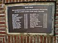 Baarn Herdenkingsmonument lijst met gevallenen 7.JPG 3,264 × 2,448; 2.62 MB
-
 Baarn monument bevrijdingsmonument.jpg 2,400 × 1,180; 453 KB
-
 Bevrijdingsmonument Baarn.jpg 4,320 × 2,432; 5.63 MB
-
 Plaquette ter herdenking van 2e W.O. slachtoffers, Baarn.jpg 4,285 × 2,369; 6.84 MB
-
 Plaquette ter herdenking van Joodse 2e W.O. slachtoffers, Baarn (1).jpg 4,320 × 2,432; 6.03 MB
-
 Plaquette ter herdenking van Joodse 2e W.O. slachtoffers, Baarn (2).jpg 4,243 × 2,297; 7.01 MB
-
 Plaquette ter herdenking van oorlogsslachtoffers Ned. Indië, Baarn.jpg 2,432 × 2,952; 4.26 MB


.jpg)
.jpg)
