Category:Bingham Canyon Mine
Vai alla navigazione
Vai alla ricerca
copper mine in Salt Lake County, Utah, United States  | |||||
| Carica un file multimediale | |||||
| Istanza di |
| ||||
|---|---|---|---|---|---|
| Luogo | contea di Salt Lake, Utah, Stati Uniti d'America | ||||
| Designazione del patrimonio | |||||
| Data di fondazione o creazione |
| ||||
 | |||||
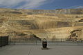
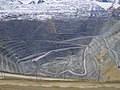
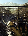
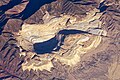
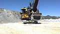
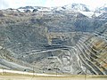
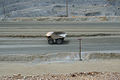
English: Media related to the Bingham Canyon Mine (more commonly known as Kennecott Copper Mine among locals), an open-pit mining operation extracting a large porphyry copper deposit Bingham Canyon in the Oquirrh Mountains southwest of South Jordan, Utah, United States.
|
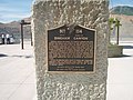
Questa è una categoria su un luogo o edificio che è elencato nel National Register of Historic Places negli Stati Uniti. Il suo numero di riferimento è [https://npgallery.nps.gov/AssetDetail/NRIS/66000736
. 66000736
.]. |
Sottocategorie
Questa categoria contiene le 4 sottocategorie indicate di seguito, su un totale di 4.
B
H
M
File nella categoria "Bingham Canyon Mine"
Questa categoria contiene 117 file, indicati di seguito, su un totale di 117.
-
 2012.09.29.104530 Bingham Canyon Mine Utah.jpg 1 920 × 1 280; 1,08 MB
-
 2012.09.29.104548 Truck Bingham Canyon Mine Utah.jpg 1 920 × 1 280; 1,16 MB
-
 2012.09.29.104551 Truck Bingham Canyon Mine Utah.jpg 1 920 × 1 280; 915 KB
-
 2012.09.29.104651 Trucks Bingham Canyon Mine Utah.jpg 1 920 × 1 280; 1,02 MB
-
 2012.09.29.104653 Trucks Bingham Canyon Mine Utah.jpg 1 920 × 1 280; 1,01 MB
-
 2012.09.29.104704 Trucks Bingham Canyon Mine Utah.jpg 1 920 × 1 280; 979 KB
-
 2012.09.29.104716 Bingham Canyon Mine Utah.jpg 1 920 × 1 280; 569 KB
-
 2012.09.29.104729 Bingham Canyon Mine Utah.jpg 1 920 × 1 280; 587 KB
-
 2012.09.29.104741 Bingham Canyon Mine Utah.jpg 1 920 × 1 280; 636 KB
-
 2012.09.29.104752 Bingham Canyon Mine Utah.jpg 1 920 × 1 280; 700 KB
-
 2012.09.29.105231 Trucks Bingham Canyon Mine Utah.jpg 1 920 × 1 280; 874 KB
-
 2012.09.29.105606 Trucks Bingham Canyon Mine Utah.jpg 1 920 × 1 280; 950 KB
-
 2012.09.29.105613 Trucks Bingham Canyon Mine Utah.jpg 1 920 × 1 280; 945 KB
-
 2012.09.29.105628 Trucks Bingham Canyon Mine Utah.jpg 1 920 × 1 280; 943 KB
-
 2012.09.29.105644 Trucks Bingham Canyon Mine Utah.jpg 1 920 × 1 280; 900 KB
-
 2012.09.29.105930 Bingham Canyon Mine Utah.jpg 1 920 × 1 280; 744 KB
-
 2012.09.29.110159 Solar panel Bingham Canyon Mine Utah.jpg 1 920 × 1 280; 915 KB
-
 2012.09.29.110242 Bingham Canyon Mine Utah.jpg 1 920 × 1 280; 866 KB
-
 2012.09.29.110739 Ore rock Bingham Canyon Mine Utah.jpg 1 920 × 1 280; 1,43 MB
-
 2012.09.29.111113 Tire sign Bingham Canyon Mine Utah.jpg 1 920 × 1 280; 969 KB
-
 2012.09.29.111243 Bingham Canyon Mine Utah.jpg 1 920 × 1 280; 794 KB
-
 2019 Bingham Canyon Mine 01.jpg 4 608 × 3 456; 3,67 MB
-
 2019 Bingham Canyon Mine 02.jpg 4 608 × 3 456; 5,32 MB
-
 2019 Bingham Canyon Mine 03.jpg 4 608 × 3 456; 4,73 MB
-
 2019 Bingham Canyon Mine 04.jpg 4 608 × 3 456; 4,23 MB
-
 2019 Bingham Canyon Mine 05.jpg 4 608 × 3 456; 3,27 MB
-
 2019 Bingham Canyon Mine 06.jpg 4 608 × 3 456; 2,96 MB
-
 2019 Bingham Canyon Mine 07.jpg 4 608 × 3 456; 3,84 MB
-
 2019 Bingham Canyon Mine 08.jpg 4 608 × 3 456; 3,41 MB
-
 2019 Bingham Canyon Mine 09.jpg 3 456 × 4 608; 4,59 MB
-
 2019 Bingham Canyon Mine 10.jpg 4 608 × 3 456; 3,85 MB
-
 2019 Bingham Canyon Mine 11.jpg 4 608 × 3 456; 3,4 MB
-
 2019 Bingham Canyon Mine 12.jpg 4 608 × 3 456; 2,9 MB
-
 2019 Bingham Canyon Mine 13.jpg 4 608 × 3 456; 2,77 MB
-
 2019 Bingham Canyon Mine 14.jpg 4 608 × 3 456; 5,75 MB
-
 Bingham Canyon April 2005.jpg 1 600 × 1 200; 878 KB
-
 Bingham Canyon Mine (1) - Salt Lake County, Utah - May 11, 2012.jpg 2 581 × 1 936; 5,29 MB
-
 Bingham Canyon Mine (2) - Salt Lake County, Utah - May 11, 2012.jpg 2 581 × 1 936; 4,63 MB
-
 Bingham Canyon Mine - Kennecott Utah Copper - panoramio.jpg 2 400 × 1 800; 740 KB
-
 Bingham Canyon mine 1942.jpg 3 500 × 2 677; 1,27 MB
-
 Bingham Canyon Mine 1942.jpg 3 974 × 5 000; 11,95 MB
-
 Bingham Canyon Mine 1942c.jpg 3 847 × 4 969; 8,51 MB
-
 Bingham Canyon mine 2007 - NASA Image.jpg 1 080 × 667; 422 KB
-
 Bingham Canyon mine 2007 annotated - NASA Image.jpg 540 × 334; 91 KB
-
 Bingham Canyon mine 2016.jpg 1 024 × 616; 312 KB
-
 Bingham Canyon mine dumps, 2004.jpg 1 152 × 864; 1,25 MB
-
 Bingham Canyon mine détail.jpg 400 × 189; 110 KB
-
 Bingham Canyon Mine from ISS 2007.jpg 857 × 571; 271 KB
-
 Bingham Canyon Mine Satellite image after Landslide.jpg 720 × 480; 159 KB
-
 Bingham Canyon Mine Satellite image before Landslide.jpg 720 × 480; 142 KB
-
 Bingham Canyon Mine, west face detail, Utah.jpg 1 800 × 1 118; 629 KB
-
 Bingham Canyon Mine.JPG 3 072 × 2 304; 1,62 MB
-
 Bingham Canyon Open Pit Copper Mine 2012-09-17 21-25-59.jpg 3 264 × 1 840; 1,98 MB
-
 Bingham Canyon UT - Utah Copper Mine (NBY 430162).jpg 827 × 526; 93 KB
-
 Bingham Copper Mine (2024-01-09-04-12-29 UMBRA-04).tiff 12 085 × 12 086, 6 pagine; 192,51 MB
-
 Bingham Copper Mine (2024-01-14-17-07-04 UMBRA-05).tiff 9 333 × 9 333, 6 pagine; 125,01 MB
-
 Bingham Copper Mine (2024-01-19-18-15-15 UMBRA-07).tiff 8 550 × 8 550, 6 pagine; 102,26 MB
-
 Bingham Copper Mine (2024-01-21-17-34-33 UMBRA-04).tiff 8 248 × 8 248, 6 pagine; 102,26 MB
-
 Bingham Copper Mine (2024-01-25-04-24-09 UMBRA-05).tiff 8 670 × 8 671, 6 pagine; 102,26 MB
-
 Bingham Copper Mine (2024-02-06-04-42-08 UMBRA-04).tiff 16 001 × 16 001, 6 pagine; 237,38 MB
-
 Bingham Copper Mine (2024-02-07-04-40-05 UMBRA-05).tiff 16 001 × 16 001, 6 pagine; 256,62 MB
-
 Bingham Copper Mine (2024-02-08-18-18-25 UMBRA-08).tiff 16 001 × 16 001, 6 pagine; 238,22 MB
-
 Bingham Copper Mine (2024-02-09-06-19-20 UMBRA-06).tiff 16 001 × 16 001; 470,13 MB
-
 Bingham Copper Mine - panoramio.jpg 3 072 × 2 304; 866 KB
-
 Bingham Copper Mine Panoramic.jpg 5 535 × 1 331; 3,6 MB
-
 Bingham Copper Mine, Bingham - panoramio.jpg 3 072 × 2 304; 681 KB
-
 Bingham Copper Mine, UT - panoramio (2).jpg 3 072 × 2 304; 684 KB
-
 Bingham Copper Mine, UT - panoramio.jpg 3 072 × 2 304; 439 KB
-
 Bingham Cross Section Sulfides.PNG 990 × 457; 110 KB
-
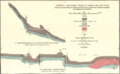
 Bingham Cross Section.PNG 875 × 530; 69 KB
-
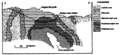
 Bingham District Geology.PNG 972 × 599; 108 KB
-
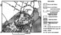 Bingham Geology.PNG 977 × 567; 136 KB
-
 Bingham Highland Boy Mine.PNG 949 × 585; 717 KB
-
 Bingham Jordan Mine.PNG 774 × 572; 466 KB
-
 Bingham Metal Zones.PNG 575 × 432; 70 KB
-
 Bingham mine 5-10-03.jpg 1 600 × 1 200; 388 KB
-
 Bingham Old Jordan Mine.PNG 951 × 587; 850 KB
-
 Bingham open pit copper mine, Utah - panoramio.jpg 1 280 × 960; 277 KB
-
 Bingham Silicate Alterations.PNG 784 × 501; 85 KB
-
 Bingham Telegraph Mine.PNG 956 × 575; 724 KB
-
 BinghamCanyon.jpg 4 288 × 2 848; 4,07 MB
-
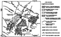
 BinghamCynGeologyMap.jpg 1 743 × 1 143; 780 KB
-
 Copper Mine (5069273777).jpg 1 286 × 854; 303 KB
-
 Copper MIne, Bingham, Salt Lake, UT - panoramio.jpg 3 072 × 2 304; 615 KB
-
 Copper pit detail, 1952 USGS map of Bingham Canyon (cropped).jpg 934 × 1 247; 530 KB
-
 Giant Tyre at Bingham Copper Mine, UT - panoramio.jpg 3 072 × 2 304; 534 KB
-
 Haul truck, Bingham Canyon mine.jpg 1 901 × 1 280; 527 KB
-
 Here by Norie Sato 11, Oct 16.jpg 2 592 × 1 944; 2,17 MB
-
 Highland Boy Mine, Bingham Canon, Utah C.R. Savage Photo..jpg 2 446 × 1 894; 1 023 KB
-
 Kennecott Bingham Canyon Mine Seen From West Jordan, Utah.jpg 3 325 × 2 217; 4,35 MB
-
 Kennecott Copper Mine - panoramio.jpg 2 816 × 2 112; 1,71 MB
-
 Kennecott Mine - Dump truck and Back Hoe.jpg 1 024 × 683; 390 KB
-
 Kennecott Mine - Dump truck from a distance..jpg 1 024 × 683; 436 KB
-
 Kennecott Mine - Dump truck.jpg 1 024 × 683; 425 KB
-
 KENNECOTT MINE IS THE LARGEST OPEN-PIT COPPER OPERATION IN THE WORLD - NARA - 544789.jpg 3 000 × 2 024; 968 KB
-
 Kennecott Mine.jpg 3 456 × 2 304; 1,89 MB
-
 Kennecott Overlook - panoramio.jpg 2 160 × 1 440; 612 KB
-

-
 MIna cobre Bingham.jpg 322 × 402; 48 KB
-
 Open-pit workings of the Utah Copper Company 1942.jpg 921 × 704; 280 KB
-
 Open-pit workings of the Utah Copper Company, Bingham Canyon1a34852v.jpg 1 024 × 828; 368 KB
-
 Oquirrh Mountains.jpg 39 842 × 3 814; 21,53 MB
-

-
 Panorama of Bingham Canyon Mine in 1907.png 3 699 × 1 037; 3,65 MB
-
 Pedestrian level crossing at South Jordan Parkway station, Apr 16.jpg 2 592 × 1 944; 2,39 MB
-
 Rocker Shovel Loader info (3671600937).jpg 3 888 × 2 592; 2,68 MB
-
 Smelter site 1952 USGS map detail, Bingham Canyon Mine (cropped).jpg 816 × 612; 163 KB
-
 Southwest at South Jordan Parkway station Park & Ride lot, Apr 16.jpg 2 592 × 1 944; 2,39 MB
-
 Southwest from Jordan Valley station, Apr 16.jpg 2 592 × 1 944; 2,3 MB
-
 THE KENNECOTT MINE IS THE LARGEST OPEN-CUT COPPER MINE IN THE WORLD - NARA - 544781.jpg 3 000 × 2 047; 931 KB
-
 Tower Optical Binoculars.jpg 1 071 × 1 476; 1,12 MB
-
 Transactions (1871) (14597325538).jpg 2 018 × 1 514; 318 KB
-
 UT Bingham Canyon 1952.jpg 3 297 × 4 023; 4,43 MB
-

-
 Utah regional geology.PNG 472 × 613; 64 KB
-
 View of the Utah Copper Company open-pit mine workings at Carr Fork1a34853v.jpg 1 024 × 821; 415 KB
-
 View west southwest from 4800 W Old Bingham Hwy station, Apr 16.jpg 2 592 × 1 944; 2,41 MB


_-_Salt_Lake_County,_Utah_-_May_11,_2012.jpg)
_-_Salt_Lake_County,_Utah_-_May_11,_2012.jpg)


.jpg)


.jpg)


.jpg)

.jpg)


.jpg)
.jpg)


_(14597325538).jpg)
Categorie:
- Copper mines in the United States
- Kennecott Utah Copper
- National Historic Landmarks in Utah
- National Register of Historic Places in Salt Lake County, Utah
- Open pit mining in the United States
- Oquirrh Mountains
- Geology of Salt Lake County, Utah
- Rio Tinto (company)
- Industrial heritage in Utah
- Industrial structures on the National Register of Historic Places in Utah
- Mines in Utah
- Bingham Canyon
- Locations along Utah State Route 209
- Economy of Salt Lake County, Utah