Category:Binnenhof 1, The Hague
Jump to navigation
Jump to search
| Object location | | View all coordinates using: OpenStreetMap |
|---|
building in The Hague, Netherlands  | |||||
| Upload media | |||||
| Instance of | |||||
|---|---|---|---|---|---|
| Location | The Hague, South Holland, Netherlands | ||||
| Heritage designation |
| ||||
 | |||||
Nederlands: Eertijds onderdeel van het Stadhouderlijk Kwartier, thans in gebruik bij de Raad van State
|
This is a category about rijksmonument number 17471
|
| Address |
|
Media in category "Binnenhof 1, The Hague"
The following 43 files are in this category, out of 43 total.
-
 Bevel Koninklijke Marechaussee in handen van Leijtens-1.jpg 3,000 × 2,000; 1.31 MB
-
 Bevel Koninklijke Marechaussee in handen van Leijtens-10 (cropped).jpg 1,236 × 1,712; 559 KB
-
 Bevel Koninklijke Marechaussee in handen van Leijtens-10.jpg 5,472 × 3,648; 1.46 MB
-
 Bevel Koninklijke Marechaussee in handen van Leijtens-2.jpg 3,000 × 2,000; 1.93 MB
-
 Bevel Koninklijke Marechaussee in handen van Leijtens-4.jpg 3,000 × 1,688; 1.98 MB
-
 Bevel Koninklijke Marechaussee in handen van Leijtens-5.jpg 5,472 × 3,648; 1.34 MB
-
 Bevel Koninklijke Marechaussee in handen van Leijtens-6.jpg 3,648 × 3,648; 1.15 MB
-
 Bevel Koninklijke Marechaussee in handen van Leijtens-7.jpg 4,016 × 2,677; 2.39 MB
-
 Bevel Koninklijke Marechaussee in handen van Leijtens-8.jpg 5,472 × 3,648; 1.36 MB
-
 Bevel Koninklijke Marechaussee in handen van Leijtens-9.jpg 5,472 × 3,648; 1.45 MB
-
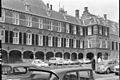
 Binnenhof noord-west zijde - 's-Gravenhage - 20085782 - RCE.jpg 1,118 × 684; 187 KB
-

-

-

-
 Dessus de porte - 's-Gravenhage - 20086171 - RCE.jpg 889 × 1,200; 230 KB
-
 Detail schildering - 's-Gravenhage - 20086170 - RCE.jpg 890 × 1,200; 182 KB
-
 Detail schouw - 's-Gravenhage - 20086164 - RCE.jpg 1,200 × 813; 176 KB
-
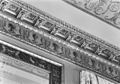 Detail van het fries - 's-Gravenhage - 20086165 - RCE.jpg 1,200 × 835; 236 KB
-
 Gevels aan de noord-zijde - 's-Gravenhage - 20085777 - RCE.jpg 1,200 × 803; 218 KB
-

-
 Hague, Kamerfracties.jpg 2,617 × 2,497; 5.4 MB
-
 Interieur - 's-Gravenhage - 20086172 - RCE.jpg 1,200 × 957; 242 KB
-
 Interieur - 's-Gravenhage - 20086173 - RCE.jpg 1,200 × 957; 238 KB
-
 Interieur - 's-Gravenhage - 20086174 - RCE.jpg 1,200 × 802; 209 KB
-
 Interieur - 's-Gravenhage - 20086175 - RCE.jpg 1,200 × 888; 211 KB
-
 Interieur - 's-Gravenhage - 20086176 - RCE.jpg 1,200 × 879; 205 KB
-
 Interieur,detail schoorsteen - 's-Gravenhage - 20086166 - RCE.jpg 1,200 × 894; 173 KB
-
 Naar het noord-westen - 's-Gravenhage - 20085802 - RCE.jpg 1,200 × 892; 172 KB
-
 Naar het noord-westen - 's-Gravenhage - 20085803 - RCE.jpg 1,200 × 899; 198 KB
-
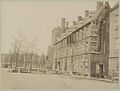
 Overzicht binnenhof - 's-Gravenhage - 20085776 - RCE.jpg 1,200 × 802; 148 KB
-
 Overzicht Binnenhof Den Haag , ext. Ridderzaal gebouw, Bestanddeelnr 922-7434.jpg 2,599 × 2,600; 1.04 MB
-
 Plafond - 's-Gravenhage - 20086167 - RCE.jpg 883 × 1,200; 238 KB
-

-
 Rm17471 ingang.JPG 3,648 × 2,736; 2.01 MB
-
 Rm17471-2.JPG 3,648 × 2,736; 2.32 MB
-
 Rm17471.JPG 3,648 × 2,736; 2.32 MB
-
 Schoorsteen - 's-Gravenhage - 20086169 - RCE.jpg 1,200 × 891; 215 KB
-
 Stoelbekleding - 's-Gravenhage - 20086162 - RCE.jpg 891 × 1,200; 257 KB
-
 Stoelbekleding - 's-Gravenhage - 20086163 - RCE.jpg 1,200 × 886; 236 KB
-
 Vergaderzaal ministerraad- plafond - 's-Gravenhage - 20403165 - RCE.jpg 1,200 × 820; 247 KB
-
 Wandtapijten - 's-Gravenhage - 20086160 - RCE.jpg 888 × 1,200; 232 KB
-
 Wandtapijten - 's-Gravenhage - 20086161 - RCE.jpg 885 × 1,200; 237 KB
-
 Zicht op gevel regeringsgebouw - 's-Gravenhage - 20320994 - RCE.jpg 1,200 × 909; 159 KB

.jpg)


