Category:Binnenpad 96, Giethoorn
Jump to navigation
Jump to search
| Object location | | View all coordinates using: OpenStreetMap |
|---|
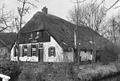
farmhouse in Steenwijkerland, Netherlands  | |||||
| Upload media | |||||
| Instance of | |||||
|---|---|---|---|---|---|
| Location | Giethoorn, Steenwijkerland, Overijssel, Netherlands | ||||
| Located on street |
| ||||
| Heritage designation |
| ||||
 | |||||
|
This is a category about rijksmonument number 10504
|
| Address |
|
Media in category "Binnenpad 96, Giethoorn"
The following 3 files are in this category, out of 3 total.
-
 Aanzicht - Giethoorn - 20078300 - RCE.jpg 1,200 × 807; 322 KB
-
 Binnenpad 96 Giethoorn.jpg 3,648 × 2,736; 1.27 MB
-
 Binnenpad 96 Giethoorn2.jpg 3,648 × 2,736; 1.23 MB

