Category:Birkenkopf (Stuttgart)
Jump to navigation
Jump to search
mountain  | |||||
| Upload media | |||||
| Instance of | |||||
|---|---|---|---|---|---|
| Location | Stuttgart, Stuttgart Government Region, Baden-Württemberg, Germany | ||||
| Elevation above sea level |
| ||||
 | |||||
Deutsch: Der Birkenkopf ist ein 511 m hoher Berg im Stadtgebiet von Stuttgart. Er ist der höchste Punkt im inneren Stadtgebiet und ragt fast 300 m übers Niveau des Neckars. Er liegt südlich des Stadtbezirks Stuttgart-Botnang und gehört noch zum Stadtbezirk Stuttgart-West.
English: The is a prominent hill in Stuttgart, Germany. At an elevation of 511m, it is the highest point in Stuttgart and is almost 300m higher than the river Neckar on which the city lies. It is in part a Schuttberg, an artificial hill built from the ruins and rubble from World War II.
Subcategories
This category has the following 2 subcategories, out of 2 total.
B
- Birkenkopfkreuz (12 F)
M
- Monte Scherbelino (Stuttgart) (72 F)
Media in category "Birkenkopf (Stuttgart)"
The following 28 files are in this category, out of 28 total.
-
 20220705 Birkenkopf, Stuttgart - DJI 0123.jpg 5,188 × 3,458; 11.05 MB
-
 Auf dem Weg zum Birkenkopf oder auch Monte Scherbelino in Stuttgart - panoramio (1).jpg 4,702 × 2,878; 6.9 MB
-
 Auf dem Weg zum Birkenkopf oder auch Monte Scherbelino in Stuttgart - panoramio.jpg 4,928 × 3,264; 8.74 MB
-
 Ausblick vom Birkenkopf oder auch Monte Scherbelino in Stuttgart - panoramio.jpg 4,928 × 2,177; 4.52 MB
-
 Birkenkopf (Erhebung in der Bildmitte).JPG 2,592 × 1,944; 2.2 MB
-
 Birkenkopf 1956.jpg 1,195 × 851; 249 KB
-
 Birkenkopf oder auch Monte Scherbelino in Stuttgart - panoramio.jpg 3,072 × 2,304; 3.25 MB
-
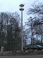 Birkenkopf Parking Lot Mobile Phone Tower.JPG 2,304 × 3,072; 1.03 MB
-
 Birkenkopf view from Berliner Platz.jpg 2,028 × 1,471; 429 KB
-
Birkenkopf.ogg 1.8 s; 49 KB
-
 Birkenkopf1.jpg 1,024 × 768; 119 KB
-
 Birkenkopfpanorama.jpg 14,120 × 2,978; 19.35 MB
-
 Blick auf die westlichen Höhenzüge Stuttgarts.JPG 2,592 × 1,944; 2.26 MB
-
 Blick Richtung Birkenkopf oder auch Monte Scherbolino - panoramio.jpg 3,264 × 2,448; 5.2 MB
-
 Blick zum Birkenkopf - panoramio.jpg 2,962 × 1,686; 914 KB
-
 Landappbw 160901 1824 Birkenkopf.jpg 1,280 × 282; 132 KB
-
 Landappbw 429684 1817 Birkenkopf Stuttgart.jpg 1,279 × 959; 166 KB
-
 Landappbw 824456 4871 Birkenkopf.jpg 1,920 × 1,440; 631 KB
-
 S23Birkenkopf03.jpg 4,032 × 3,024; 4.75 MB
-
 S23Birkenkopf04.jpg 4,032 × 3,024; 3.95 MB
-
 S23Birkenkopf05.jpg 3,864 × 2,270; 3.27 MB
-
 S23Birkenkopf07.jpg 4,032 × 3,024; 7.04 MB
-
 S23Birkenkopf08.jpg 4,032 × 3,024; 4.52 MB
-
 S23Birkenkopf10.jpg 3,024 × 4,032; 5.69 MB
-
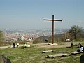
 Steintafel am Stuttgarter Birkenkopf.jpg 2,048 × 1,536; 1.66 MB
-
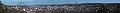 Stuttgart Panorama 2007.jpg 15,728 × 1,752; 4.35 MB
-
 Stuttgart View from Birkenkopf.jpg 2,048 × 1,536; 1.4 MB
-
 Tracks around the Birkenkopf.png 1,300 × 1,050; 467 KB

.jpg)


.JPG)


