Category:Blackburne House
Jump to navigation
Jump to search
| Object location | | View all coordinates using: OpenStreetMap |
|---|
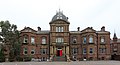
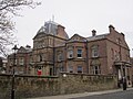
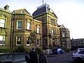
Grade II listed building in Liverpool, UK  | |||||
| Upload media | |||||
| Instance of |
| ||||
|---|---|---|---|---|---|
| Location | Liverpool, Merseyside, North West England, England | ||||
| Occupant |
| ||||
| Heritage designation |
| ||||
 | |||||
Subcategories
This category has the following 3 subcategories, out of 3 total.
Media in category "Blackburne House"
The following 9 files are in this category, out of 9 total.
-
 Blackburne House (109162172).jpg 1,932 × 1,324; 1.1 MB
-
 Blackburne House 2018.jpg 4,784 × 2,584; 8.1 MB
-
 Blackburne House plaque.jpg 3,552 × 3,268; 9.31 MB
-
 Blackburne House, Liverpool (2).JPG 4,320 × 3,240; 3.3 MB
-
 Blackburne House, Liverpool-2930855993.jpg 1,280 × 960; 273 KB
-
 Blackburne House.JPG 1,840 × 1,232; 985 KB
-
 Blackburne Place and Blackburne House, Liverpool. (10332077333).jpg 4,320 × 3,240; 5.89 MB
-
 Blackburne-House-Girls-School-1930s-Blazer-Badge.jpg 1,235 × 1,378; 2.28 MB
-
 Tympanum, Blackburne House.jpg 4,820 × 3,268; 8.53 MB
.jpg)

.JPG)


.jpg)
