Category:Bloemendalergouw 13, Ransdorp
Jump to navigation
Jump to search
| Object location | | View all coordinates using: OpenStreetMap |
|---|
 | |||||
| Upload media | |||||
| Instance of | |||||
|---|---|---|---|---|---|
| Location | Amsterdam, North Holland, Netherlands | ||||
| Street address |
| ||||
| Heritage designation |
| ||||
 | |||||
|
This is a category about rijksmonument number 6733
|
| Address |
|
Media in category "Bloemendalergouw 13, Ransdorp"
The following 3 files are in this category, out of 3 total.
-
 Aanzicht - Ransdorp - 20184468 - RCE.jpg 1,200 × 803; 239 KB
-
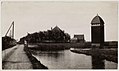 Jacobus van Eck, Afb A01634000247.jpg 1,680 × 998; 242 KB
-
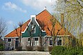 Ransdorp, Bloemendalergouw 13.jpeg 3,866 × 2,577; 1.92 MB

