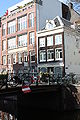
Category:Bloemgracht 132, Amsterdam
Jump to navigation
Jump to search
| Object location | | View all coordinates using: OpenStreetMap |
|---|
 | |||||
| Upload media | |||||
| Instance of | |||||
|---|---|---|---|---|---|
| Location | Amsterdam, North Holland, Netherlands | ||||
| Street address |
| ||||
| Located on street | |||||
| Heritage designation |
| ||||
 | |||||
|
This is a category about rijksmonument number 574
|
| Address |
|
Media in category "Bloemgracht 132, Amsterdam"
The following 5 files are in this category, out of 5 total.
-
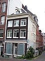 Amsterdam Bloemgracht 132 corner with Tweede Bloemdwarsstraat.jpg 1,728 × 2,304; 868 KB
-
 Amsterdam Zentrum 20091106 094.JPG 2,848 × 4,272; 4.81 MB
-
 Overzicht evenzijde hoek Bloemgracht - Amsterdam - 20018912 - RCE.jpg 1,184 × 1,200; 298 KB
-
 Overzicht voorgevel - Amsterdam - 20016109 - RCE.jpg 1,200 × 1,180; 328 KB
-
 Voorgevel - Amsterdam - 20016110 - RCE.jpg 1,188 × 1,200; 368 KB


