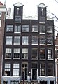
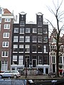
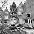
Category:Bloemgracht 85, Amsterdam
Jump to navigation
Jump to search
| Object location | | View all coordinates using: OpenStreetMap |
|---|
 | |||||
| Upload media | |||||
| Instance of |
| ||||
|---|---|---|---|---|---|
| Location | Amsterdam, North Holland, Netherlands | ||||
| Street address |
| ||||
| Located on street | |||||
| Heritage designation |
| ||||
 | |||||
|
This is a category about rijksmonument number 530
|
| Address |
|
Media in category "Bloemgracht 85, Amsterdam"
The following 13 files are in this category, out of 13 total.
-
 Achterhuis nr. - Amsterdam - 20016095 - RCE.jpg 1,188 × 1,200; 350 KB
-
 Amsterdam Bloemgracht 83 and 85 doors.jpg 2,304 × 1,728; 1.13 MB
-
 Amsterdam Bloemgracht 85 door.jpg 1,728 × 2,304; 1.07 MB
-
 Amsterdam Bloemgracht 85 top.jpg 1,728 × 2,304; 986 KB
-
 Amsterdam Zentrum 20091106 111.JPG 2,848 × 4,272; 4.3 MB
-
 Amsterdam Zentrum 20091106 114.JPG 4,272 × 2,848; 3.71 MB
-
 Bloemgracht 83.jpg 1,508 × 2,180; 274 KB
-
 Bloemgracht 85.JPG 2,304 × 3,072; 1.72 MB
-
 Detail achterhuis nr. - Amsterdam - 20016096 - RCE.jpg 1,183 × 1,200; 374 KB
-
 Detail achterhuis nr. - Amsterdam - 20016097 - RCE.jpg 1,195 × 1,200; 199 KB
-
 Exterieur VOORGEVELS, OVERZICHT - Amsterdam - 20298470 - RCE.jpg 960 × 1,200; 373 KB
-
 Overzicht achtergevels (achterhuis) - Amsterdam - 20016094 - RCE.jpg 1,186 × 1,200; 325 KB
-
 Overzicht achtergevels - Amsterdam - 20016093 - RCE.jpg 1,195 × 1,200; 343 KB


_-_Amsterdam_-_20016094_-_RCE.jpg)
