Category:Bomb damage maps of London
Jump to navigation
Jump to search
Media in category "Bomb damage maps of London"
The following 12 files are in this category, out of 12 total.
-
 Bomb damage map of the Metropolitan Borough of Hampstead, c. 1946.jpg 3,457 × 2,364; 1.25 MB
-
 Greenwell Street bomb damage map.jpg 650 × 679; 126 KB
-
 Bomb damage map Milford Lane (July 1944) and Temple (Dec 1940).jpg 513 × 356; 115 KB
-
 City of London Bomb Damage Map Trump Street & Russia Row.jpg 414 × 340; 100 KB
-
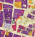 City of London Bomb Damage Map Wood Street and Milk Street.jpg 550 × 587; 368 KB
-
 City of London Bomb Damage Map.jpg 1,988 × 2,780; 2.74 MB
-
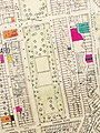
 Air Raid Damage Map - East Marylebone.jpg 1,783 × 2,229; 2.08 MB
-
 Map of the density of bombing, London region, to October 1941 (HO193-45) (29282975318).jpg 4,500 × 4,107; 2.16 MB
-
-

-
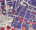 Noble Street and surrounding area Bombing, mapped in 1945.png 2,038 × 1,739; 7.09 MB
-
 Second World War bomb damage map Cadogan Place area.jpg 1,126 × 1,506; 1.08 MB


_and_Temple_(Dec_1940).jpg)


_(29282975318).jpg)


_by_Herbert_Green._Original_from_Museum_of_New_Zealand._Digitally_enhanced_by_rawpixel._(50623712777).jpg)