Category:Bonn
Jump to navigation
Jump to search
| Category Bonn on sister projects: | |||||||||
|---|---|---|---|---|---|---|---|---|---|
de: en: es: fr: it: ksh: nl: pl: pt: ru: |
Wikinews |
Wikisource |
Wikiquote |
Commons
| |||||
| Flagge / Flag | Wappen / Coat of arms | Lage / Location |
|---|---|---|
 |
 |
 |
Deutsch: Die Bundesstadt Bonn ist eine Stadt in Deutschland und die ehemalige Bundeshauptstadt
English: The “Federal City” of Bonn is the former capital of Germany.
city in and former capital of Germany    | |||||
| Upload media | |||||
| Instance of |
| ||||
|---|---|---|---|---|---|
| Part of | |||||
| Location | Cologne Government Region, North Rhine-Westphalia, Germany | ||||
| Located in or next to body of water | |||||
| Head of government |
| ||||
| Significant event |
| ||||
| Highest point |
| ||||
| Population |
| ||||
| Area |
| ||||
| Elevation above sea level |
| ||||
| Different from | |||||
| official website | |||||
 | |||||
Subcategories
This category has the following 41 subcategories, out of 41 total.
*
- Valued images of Bonn (55 F)
A
- AE 1930, 0019 (4 F)
B
D
E
G
L
N
- Notgeld coins of Bonn (2 F)
O
P
S
T
V
~
▦
- Gallery pages of Bonn (47 P)
Pages in category "Bonn"
The following 3 pages are in this category, out of 3 total.
Media in category "Bonn"
The following 92 files are in this category, out of 92 total.
-
De-Bonn2.ogg 1.4 s; 15 KB
-
-
 240403 Pegel Bonn.jpg 2,400 × 2,400; 1.88 MB
-
 Bonn 20210408 101519.jpg 8,000 × 6,000; 8.88 MB
-
 Bonn 20210408 101522.jpg 8,000 × 6,000; 8.53 MB
-
 Bonn 20210408 105243.jpg 8,000 × 6,000; 12.79 MB
-
 Bonn 20210408 105253.jpg 8,000 × 6,000; 15.7 MB
-
 Bonn 20210408 105559.jpg 8,000 × 6,000; 15.93 MB
-
 Bonn 20210408 105716.jpg 6,000 × 8,000; 14.37 MB
-
 Bonn 20210408 111957.jpg 8,000 × 6,000; 12.41 MB
-
 Bonn 20210408 112123.jpg 8,000 × 6,000; 14.54 MB
-
 Bonn 20210408 112208.jpg 8,000 × 6,000; 14.43 MB
-
 Bonn 20210408 112213.jpg 4,608 × 3,456; 3.38 MB
-
 Bonn 20210408 112230.jpg 8,000 × 6,000; 8.73 MB
-
 Bonn 20210408 112308.jpg 8,000 × 6,000; 17.22 MB
-
 Bonn 20210408 112435.jpg 4,608 × 3,456; 4.53 MB
-
 Bonn 20210408 112441.jpg 6,000 × 8,000; 13.72 MB
-
 Bonn 20210408 112738.jpg 8,000 × 6,000; 20.24 MB
-
 Bonn 20210408 113135.jpg 4,608 × 3,456; 4.06 MB
-
 Bonn 20210408 113521.jpg 8,000 × 6,000; 17.58 MB
-
 Bonn 20210408 114015.jpg 8,000 × 6,000; 19.05 MB
-
 Bonn 20210408 114432.jpg 8,000 × 6,000; 13.51 MB
-
 Bonn 20210408 120029.jpg 6,000 × 8,000; 9.82 MB
-
 Bonn 20210408 122326.jpg 6,000 × 8,000; 12.48 MB
-
 Bonn 20210408 122359.jpg 4,608 × 3,456; 3.08 MB
-
 Bonn 20210408 122408.jpg 8,000 × 6,000; 4.97 MB
-
 Bonn 20210408 122747.jpg 8,000 × 6,000; 14.01 MB
-
 Bonn 20210408 122846.jpg 8,000 × 6,000; 12.85 MB
-
 Bonn 20210408 125752.jpg 8,000 × 6,000; 12.06 MB
-
 Bonn 20210408 125757.jpg 8,000 × 6,000; 9.45 MB
-
 Bonn 20210408 125906.jpg 6,000 × 8,000; 14.76 MB
-
 Bonn 20210408 130406.jpg 8,000 × 6,000; 7 MB
-
 Bonn 20210408 130810.jpg 8,000 × 6,000; 15.46 MB
-
 Bonn 20210408 132450.jpg 8,000 × 6,000; 19.58 MB
-
 Bonn 20210408 133109.jpg 8,000 × 6,000; 18.25 MB
-
 Bonn Beauty (16871180590).jpg 4,870 × 3,226; 4.78 MB
-
-

-
 Bonn, Venusberg-Campus, Mulholland, Transfiguration.jpg 5,184 × 3,456; 14.4 MB
-
 Bonn-muellheizkraftwerk-am-dickobskreuz-ecke-immenburgstrasse-am-25-7-2024.jpg 4,032 × 3,024; 7.28 MB
-
De-Bonn.ogg 0.8 s; 15 KB
-
 Die Sieg im Mündungsbereich, flussaufwärts.jpg 3,264 × 2,448; 3.43 MB
-
 DIE.jpg 5,472 × 3,648; 2.16 MB
-
 Diplomarbei Fahrradwegenetz und Fahrradunfälle in Bonn 1988 - 1990 Robert Mohr.jpg 3,024 × 4,032; 2.53 MB
-
 Eine halbe Milliarde fürs WCCB.jpg 1,504 × 1,624; 405 KB
-
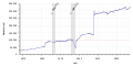 Einwohnerentwicklung von Bonn - ab 1871.svg 800 × 400; 78 KB
-
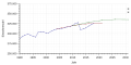 Einwohnerentwicklung von Bonn - Prognosen.svg 800 × 400; 64 KB
-
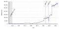 Einwohnerentwicklung von Bonn.svg 800 × 400; 91 KB
-
 Festspielhaus Beethoven soll in die Bonner Rheinaue.jpg 1,088 × 872; 200 KB
-
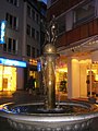
 Fountain - panoramio (16).jpg 1,536 × 2,048; 1.77 MB
-
 Fountain - panoramio (17).jpg 1,536 × 2,048; 1.78 MB
-
 Garten der Erinnerung.jpg 1,608 × 2,328; 2.88 MB
-
 Guerilla Gardening am Siegauen Deich - panoramio.jpg 1,301 × 975; 1.08 MB
-
 Hedgehog at night.jpg 4,032 × 3,024; 4.53 MB
-
 Hirschgehege am Rhein, Bonn, 11.2012 - panoramio.jpg 2,560 × 1,920; 2.4 MB
-
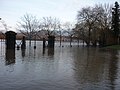 Hochwasser am Mausoleum von Carstanjen, 01.2011 - panoramio.jpg 2,560 × 1,920; 2.31 MB
-
 Hochwasser am Rhein, 01.2011 - panoramio.jpg 2,560 × 1,920; 2.16 MB
-
 Hockeyspiel Richard Wagner Straße.jpg 985 × 620; 222 KB
-
 Hofgarten Bonn (14247593110).jpg 3,797 × 2,078; 5.66 MB
-
 Häuserreihe am Münsterberger Weg, 09.2011 - panoramio.jpg 2,560 × 1,920; 1.31 MB
-
 Illumint.jpg 595 × 1,024; 223 KB
-
 Jugendherberge Bonn. Helmuth Linder Russlandalbum. helmuth0010-1.png 2,013 × 1,353; 3 MB
-
 Kreuzung Oppelner Str.-Agnetendorfer Str., 09.2011 - panoramio.jpg 2,560 × 1,920; 2.29 MB
-
 Libelle nach dem Schlüpfen - panoramio.jpg 1,163 × 876; 592 KB
-
 Logo der Veranstaltung BONN-SPIELT 2024.jpg 2,000 × 2,000; 125 KB
-
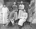 Maria von Linden und Kollegen.jpg 493 × 393; 33 KB
-
 MIDI - panoramio.jpg 2,048 × 1,536; 1.32 MB
-
 Mobile Manipulation Robot Momaro.jpg 3,000 × 4,000; 3.37 MB
-
 Neues Gebäude für das Schulzentrum Tannenbusch, 09.2011 - panoramio.jpg 2,560 × 1,920; 2.33 MB
-
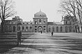 Poppelsdorf Palace, Bonn, 1946.jpg 1,975 × 1,301; 898 KB
-
 Poppelsdorferalle (23111609).jpeg 2,048 × 2,048; 222 KB
-
 Prozorec vo bonn.jpg 4,128 × 3,096; 1.63 MB
-
 Quantiasstaße bike lane.jpg 4,208 × 1,942; 3.51 MB
-
 Regenbogen Bonn und Rhein.jpg 5,568 × 3,712; 733 KB
-
 Regenbogen über Rhein.jpg 5,568 × 3,712; 994 KB
-
 Rhein in Bonn bei Sonnenaufgang.jpg 3,697 × 2,079; 1.07 MB
-
 Rheinblick - panoramio (1).jpg 3,264 × 2,448; 1.85 MB
-
 Richtung Bonn - panoramio.jpg 2,560 × 1,920; 2.02 MB
-
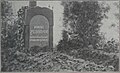 Robert Schumann's old grave, Bonn, 1873.jpg 1,316 × 802; 185 KB
-
 Rohmühle Bonn-Oberkassel, Vogelschau 1906.jpg 2,254 × 1,295; 1.26 MB
-
 Sommer 2023 (Alter Fritz) 45.jpg 3,024 × 4,032; 4.33 MB
-
 Sterntor - panoramio (1).jpg 2,048 × 1,536; 1.53 MB
-
 Street food festival, Bonn, September 2021.jpg 2,160 × 3,840; 2.46 MB
-
 Unverpixelt - panoramio (3).jpg 2,816 × 2,112; 2.66 MB
-
 Unverpixelt - panoramio (4).jpg 2,816 × 2,112; 2.48 MB
-
 Vortragsveranstaltung Bonn.jpg 4,608 × 2,240; 3.78 MB
-
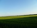
 Weideland zwischen Pützchen und Holzlar.jpg 3,120 × 4,160; 5.76 MB
-
 Wohngebäude am Rhein, Rüngsdorf, 11.2011 - panoramio.jpg 2,560 × 1,920; 2.32 MB
-
 Zeichen 310 - Ortstafel (Vorderseite) - StVO 1970.svg 1,000 × 650; 12 KB
-
 Zeichen 311 - Ortstafel (Rückseite) - StVO 1970.svg 1,000 × 650; 12 KB
-

-
 Zwischen Pützchen und Holzlar.jpg 3,120 × 4,160; 3.68 MB
.jpg)


.jpg)


.jpg)
.jpg)


.jpg)


.jpeg)


.jpg)


_45.jpg)
.jpg)


_-_StVO_1970.svg)
_-_StVO_1970.svg)

.jpg)
.jpg)
,_(1500x333),_StVO_1970.svg)
Categories:
- Urban districts in North Rhine-Westphalia
- Cities on the Rhine
- Regierungsbezirk Köln
- Rhein-Ruhr
- Populated places established in the 1st century BC
- Former national capitals
- Ancient Roman settlements in Germany by German name
- Establishments in North Rhine-Westphalia in the 1st century BC
- Cities in North Rhine-Westphalia