Category:Bonner Straße 51 (Grafschaft, Rheinland)
Jump to navigation
Jump to search
| Object location | | View all coordinates using: OpenStreetMap |
|---|
Media in category "Bonner Straße 51 (Grafschaft, Rheinland)"
The following 5 files are in this category, out of 5 total.
-
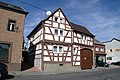 Fachwerkhaus, Gelsdorf, Bonner Strasse 51 (1).jpg 4,770 × 3,178; 9.55 MB
-
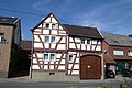
 Fachwerkhaus, Gelsdorf, Bonner Strasse 51 (2).jpg 3,178 × 3,648; 7.15 MB
-
 Fachwerkhaus, Gelsdorf, Bonner Strasse 51 (3).jpg 4,770 × 3,178; 9.66 MB
-
 Fachwerkhaus, Gelsdorf, Bonner Strasse 51 (4).jpg 4,770 × 3,178; 9.57 MB
-
 Fachwerkhaus, Gelsdorf, Bonner Strasse 51 (5).jpg 3,168 × 4,672; 6.68 MB
.jpg)
.jpg)
.jpg)
.jpg)
.jpg)