Category:Boomsestraat 13, Balgoij
Jump to navigation
Jump to search
| Object location | | View all coordinates using: OpenStreetMap |
|---|
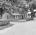
farmhouse in Wijchen, Netherlands _Rijksmonument_32133_Boomsestraat_13.JPG) | |||||
| Upload media | |||||
| Instance of | |||||
|---|---|---|---|---|---|
| Location | Balgoij, Gelderland, Netherlands | ||||
| Street address |
| ||||
| Heritage designation |
| ||||
 | |||||
|
This is a category about rijksmonument number 32133
|
| Address |
|
Media in category "Boomsestraat 13, Balgoij"
The following 4 files are in this category, out of 4 total.
-
 Balgoy (Wijchen) Rijksmonument 32133 Boomsestraat 13.JPG 3,648 × 2,736; 4.23 MB
-
 Gevels - Balgoy - 20027613 - RCE.jpg 1,200 × 1,189; 306 KB
-
 Gevels - Balgoy - 20027614 - RCE.jpg 1,200 × 1,180; 346 KB
-
 Voorgevel - Balgoy - 20027615 - RCE.jpg 1,200 × 960; 264 KB


