Category:Bordet station
Jump to navigation
Jump to search
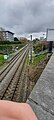
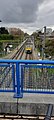
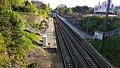
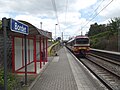
English: The Bordet railway station is a railway station in Brussels, Belgium. It is located on the line 26 between the stations of Haren and Evere. The station is located in the municipality of Evere, next to the border with the City of Brussels, at the crossroad between the Chaussée de Haecht/Haachtsesteenweg and the Avenue Jules Bordet/Jules Bordetlaan.
Français : La gare de Bordet est une gare ferroviaire belge de la ligne 26 de Schaerbeek à Hal, située sur le territoire de la commune d'Evere dans la région de Bruxelles-Capitale. À la jonction de l'avenue Jules Bordet et de la chaussée de Haecht, près de Haren.
Nederlands: Station Bordet is een spoorweghalte en MIVB-tram- en bushalte in de Brusselse gemeente Evere. Het spoorwegstation ligt aan lijn 26 (Schaarbeek - Halle), die het oosten en zuiden van het Brussels Hoofdstedelijk Gewest doorkruist. Het station bestaat uit twee perrons en is gelegen in een afgraving, direct ten zuiden van de kruising van de Haachtsesteenweg en Jules Bordetlaan, waaraan het zijn naam dankt.
| Object location | | View all coordinates using: OpenStreetMap |
|---|
railway station in Belgium  | |||||
| Upload media | |||||
| Instance of | |||||
|---|---|---|---|---|---|
| Named after |
| ||||
| Location | Evere, Arrondissement of Brussels-Capital, Brussels-Capital Region, Brussels, Coop of Brussels, Duchy of Brabant | ||||
| Transport network | |||||
| Owned by | |||||
| Operator | |||||
| Date of official opening |
| ||||
| Elevation above sea level |
| ||||
| Connecting line | |||||
| Adjacent station |
| ||||
| Interchange station |
| ||||
| official website | |||||
 | |||||
Media in category "Bordet station"
The following 28 files are in this category, out of 28 total.
-
 (NMBS) Naambord Bordet.png 2,519 × 277; 21 KB
-
 Bordet sortie voie 2 - 2018-08-08.jpg 4,896 × 3,672; 7.59 MB
-
 Bordet station 2018 01.jpg 3,648 × 2,736; 4.63 MB
-
 Bordet station 2018 02.jpg 3,648 × 2,736; 4.67 MB
-
 Brussels 22 29 05 538000.jpeg 3,024 × 4,032; 4.55 MB
-
 Brussels 22 29 18 193000.jpeg 3,024 × 4,032; 4.83 MB
-
 Brussels 22 29 27 080000.jpeg 4,032 × 3,024; 4.76 MB
-
 Bruxelles - Gare de Bordet - 000.jpg 3,012 × 725; 134 KB
-
 Bruxelles - Gare de Bordet - 001.jpg 3,648 × 2,736; 5.7 MB
-
 Bruxelles - Gare de Bordet - 002.jpg 3,648 × 2,736; 5.81 MB
-
 Evere 20230407 4.jpg 1,800 × 4,000; 2.75 MB
-
 Evere 20230407 5.jpg 1,800 × 4,000; 2.36 MB
-
 Evere 20230407 6.jpg 1,800 × 4,000; 2.22 MB
-
 Evere 20230407 7.jpg 1,800 × 4,000; 1.99 MB
-
 Evere 20230407 8.jpg 1,800 × 4,000; 2.17 MB
-
 Evere 20230407 9.jpg 1,800 × 4,000; 1.99 MB
-
 Gare de Bordet (01).jpg 5,212 × 2,787; 2.8 MB
-
 Gare de Bordet (02).jpg 5,312 × 2,988; 7.11 MB
-
 Gare de Bordet (03).jpg 5,312 × 2,988; 8.76 MB
-
 Gare de Bordet 28 octobre 2024 02.jpg 3,648 × 5,472; 12.86 MB
-
 Gare de Bordet 28 octobre 2024, passerelle 01.jpg 5,472 × 3,648; 15.22 MB
-
 Station Bordet 2015.jpg 4,288 × 3,216; 3.75 MB
-
 Station Bordet en meettrein I.JPG 4,288 × 3,216; 3.63 MB
-
 Station Bordet en meettrein II.JPG 4,288 × 3,216; 3.59 MB
-
 Station Bordet in de sneeuw.JPG 2,592 × 1,944; 644 KB
-
 Station Bordet Naam.jpg 4,032 × 2,268; 11.91 MB
-
 Station Bordet Perron.jpg 4,032 × 2,268; 12.08 MB
-
 Station Bordet Sporen.jpg 4,032 × 2,268; 10.07 MB


.jpg)
.jpg)
.jpg)


_Naambord_Bordet.png)