Category:Borne armoriée du Mont Morin
Jump to navigation
Jump to search
|
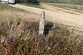
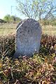
This building is inscrit au titre des monuments historiques de la France. It is indexed in the base Mérimée, a database of architectural heritage maintained by the French Ministry of Culture, under the references PA00113408
|
| Object location | | View all coordinates using: OpenStreetMap |
|---|
 | |||||
| Upload media | |||||
| Instance of | |||||
|---|---|---|---|---|---|
| Part of |
| ||||
| Location | |||||
| Street address |
| ||||
| Heritage designation |
| ||||
 | |||||
Media in category "Borne armoriée du Mont Morin"
The following 10 files are in this category, out of 10 total.
-
 Borne armoriée Mont Morin Mercurey 1.jpg 5,184 × 3,456; 10.69 MB
-
 Borne armoriée Mont Morin Mercurey 10.jpg 5,184 × 3,456; 9.67 MB
-
 Borne armoriée Mont Morin Mercurey 2.jpg 5,184 × 3,456; 9.94 MB
-
 Borne armoriée Mont Morin Mercurey 3.jpg 5,184 × 3,456; 9.57 MB
-
 Borne armoriée Mont Morin Mercurey 4.jpg 5,184 × 3,456; 8.87 MB
-
 Borne armoriée Mont Morin Mercurey 5.jpg 5,184 × 3,456; 10.47 MB
-
 Borne armoriée Mont Morin Mercurey 6.jpg 5,184 × 3,456; 9.43 MB
-
 Borne armoriée Mont Morin Mercurey 7.jpg 5,184 × 3,456; 8.52 MB
-
 Borne armoriée Mont Morin Mercurey 8.jpg 3,456 × 5,184; 7.92 MB
-
 Borne armoriée Mont Morin Mercurey 9.jpg 3,456 × 5,184; 8.55 MB


