Category:Boterhuismolen
Jump to navigation
Jump to search
| Object location | | View all coordinates using: OpenStreetMap |
|---|
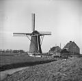
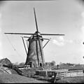
windmill in Warmond, Netherlands  | |||||
| Upload media | |||||
| Instance of |
| ||||
|---|---|---|---|---|---|
| Location | Warmond, South Holland, Netherlands | ||||
| Street address |
| ||||
| Located on street |
| ||||
| Has use |
| ||||
| Heritage designation |
| ||||
| Source of energy | |||||
 | |||||
|
This is a category about rijksmonument number 38312
|
| Address |
|
Media in category "Boterhuismolen"
The following 19 files are in this category, out of 19 total.
-
 Aan water gelegen ronde stenen molen - Warmond - 20407146 - RCE.jpg 1,186 × 1,200; 238 KB
-
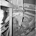 Boterhuismolen, gekraakt voeghout, keerstijl zijde - Warmond - 20250037 - RCE.jpg 1,200 × 1,176; 257 KB
-
 Boterhuismolen, nieuwe kap montering - Warmond - 20250028 - RCE.jpg 1,200 × 1,172; 204 KB
-
 Boterhuismolen, Rietdekkers aan 't werk - Warmond - 20250026 - RCE.jpg 1,200 × 1,175; 197 KB
-
 Boterhuismolen, voorzijde voeghout - Warmond - 20250038 - RCE.jpg 1,200 × 1,172; 232 KB
-
 Boterhuismolen, watermolen - Warmond - 20250027 - RCE.jpg 1,200 × 1,181; 221 KB
-
 Boterhuispolder gezien vanuit het noorden - Warmond - 20250024 - RCE.jpg 1,200 × 1,186; 222 KB
-
 In restauratie - Warmond - 20250017 - RCE.jpg 1,200 × 1,181; 211 KB
-
 Warmond Booterhuismolen.jpg 1,400 × 2,100; 1.51 MB
-
 Warmond Boterhuismolen.jpg 1,400 × 1,967; 1.41 MB
-
 Watermolen "De Booterhuis" - Warmond - 20250073 - RCE.jpg 1,200 × 1,183; 200 KB
-
 Watermolen "De Booterhuis" - Warmond - 20250074 - RCE.jpg 1,200 × 1,189; 198 KB
-
 Watermolen Boterhuispolder gezien vanuit het oosten - Warmond - 20250025 - RCE.jpg 1,200 × 1,192; 220 KB
-
 Watermolen van de Boterhuispolder - Warmond - 20250019 - RCE.jpg 1,200 × 1,184; 227 KB
-
 Watermolen van de Boterhuispolder - Warmond - 20250020 - RCE.jpg 1,200 × 1,196; 289 KB
-

-

-
 Watermolen van de Boterhuispolder, exterieur - Warmond - 20250014 - RCE.jpg 1,200 × 1,200; 203 KB
-
 Watermolen van de Boterhuispolder, metselaar aan het werk - Warmond - 20250023 - RCE.jpg 1,200 × 1,183; 252 KB


