Category:Boundary stone (GDH - GDF) No105
Jump to navigation
Jump to search
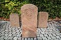
English: Boundary stone between GDH and GDF from 1810 with the number 105. The original site (look at object location) of the boundary stone was between Hohl and Hörstein. It was transferred to the water tower in Kahl (look at camera location).
Deutsch: Grenzstein zwischen GH und GF von 1810 mit der Nummer 105. Der Originalstandort des Grenzsteins (siehe Objektposition) lag zwischen Hohl und Hörstein. Er wurde zum Kahler Wasserturm verlegt (siehe Kameraposition).
| Object location | | View all coordinates using: OpenStreetMap |
|---|
| Camera location | | View all coordinates using: OpenStreetMap |
|---|
Media in category "Boundary stone (GDH - GDF) No105"
The following 3 files are in this category, out of 3 total.
-
 Grenzstein 105 GH - GF(1).jpg 3,456 × 5,184; 6.63 MB
-
 Grenzstein 105 GH - GF(2).jpg 5,184 × 3,456; 7.26 MB
-
 Grenzstein 105 GH - GF(3).jpg 5,184 × 3,456; 6.81 MB
.jpg)
.jpg)
.jpg)