Category:Breestraat 39, Leiden
Jump to navigation
Jump to search
| Object location | | View all coordinates using: OpenStreetMap |
|---|
building in Leiden, Netherlands  | |||||
| Upload media | |||||
| Instance of | |||||
|---|---|---|---|---|---|
| Location | Leiden, South Holland, Netherlands | ||||
| Heritage designation |
| ||||
 | |||||
|
This is a category about rijksmonument number 24600
|
| Address |
|
Media in category "Breestraat 39, Leiden"
The following 19 files are in this category, out of 19 total.
-
 Detail stucwerk in trappenhuis - Leiden - 20135697 - RCE.jpg 958 × 1,200; 167 KB
-
 Detail trappenhuis - Leiden - 20135687 - RCE.jpg 881 × 1,200; 129 KB
-
 Detail trappenhuis - Leiden - 20135688 - RCE.jpg 883 × 1,200; 146 KB
-
 Detail trappenhuis, stucwerk - Leiden - 20135684 - RCE.jpg 895 × 1,200; 132 KB
-
 Detail trappenhuis, stucwerk - Leiden - 20135685 - RCE.jpg 884 × 1,200; 155 KB
-
 Detail trappenhuis, stucwerk - Leiden - 20135686 - RCE.jpg 880 × 1,200; 166 KB
-
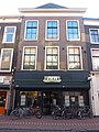
 Leiden - Breestraat 39 v2.jpg 3,024 × 4,032; 1.77 MB
-
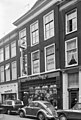
 Leiden - Breestraat 39.JPG 2,736 × 3,648; 4.39 MB
-
 Plafondschildering - Leiden - 20135692 - RCE.jpg 1,200 × 887; 183 KB
-
 Plafondschildering - Leiden - 20135693 - RCE.jpg 1,200 × 883; 170 KB
-
 Plafondschildering - Leiden - 20135694 - RCE.jpg 1,200 × 889; 181 KB
-
 Plafondschildering - Leiden - 20135695 - RCE.jpg 1,200 × 881; 177 KB
-
 Schoorsteen achtergebouw - Leiden - 20135689 - RCE.jpg 883 × 1,200; 151 KB
-
 Stucwand in trappenhuis - Leiden - 20135698 - RCE.jpg 1,200 × 1,020; 146 KB
-
 Stucwand trappenhuis - Leiden - 20135696 - RCE.jpg 961 × 1,200; 140 KB
-
 Trappenhuis - Leiden - 20135699 - RCE.jpg 959 × 1,200; 141 KB
-
 Voorgevel - Leiden - 20135700 - RCE.jpg 812 × 1,200; 211 KB
-
 Voorkamer, plafondschildering - Leiden - 20135690 - RCE.jpg 879 × 1,200; 117 KB
-
 Voorkamer, plafondschildering - Leiden - 20135691 - RCE.jpg 894 × 1,200; 164 KB


